Majarshin
Majarshin
Persian: مجارشين | |
|---|---|
Village | |
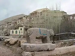 The village of Majarshin | |
 Majarshin | |
| Coordinates: 37°44′12″N 46°09′10″E / 37.73667°N 46.15278°E[1] | |
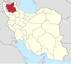
| Country | Iran |
| Province | East Azerbaijan |
| County | Osku |
| District | Central |
| Rural District | Gonbar |
| Population (2016)[2] | |
• Total | 1,037 |
| Time zone | UTC+3:30 (IRST) |
Majarshin (Persian: مجارشين)[a] is a village in Gonbar Rural District of the Central District in Osku County, East Azerbaijan province, Iran.
Majarshin village is located in the foothills of Yeke Soura Majarshin village.
Demographics
Population
At the time of the 2006 National Census, the village's population was 1,078 in 264 households.[4] The following census in 2011 counted 1,122 people in 315 households.[5] The 2016 census measured the population of the village as 1,034 people in 295 households.[2]
Majarshin is the ancient and historical village that has a green positive nature and is mountainous. The village currently has a population of approximately 1300 people.
Geography and Economics
Majarshin was originally Mirza neshin (a place where the people of high rank of society mostly lived) and in Reza Shah Pahlavi's time of policy of cultural assimilation which changing the name of cities was part of it, the name of village was changed. But, the residents of this village and surrounding villages apply the name of the village with its old dialect "Mirzeh Neshin" or (mirza neshin) the main activities of village's residents are in the areas of agriculture, horticulture, animal husbandry and carpet. The main source of income for the village Majarshin, is selling agricultural products such as nuts, raw rose and pussy. Potatoes represent the emblem of Majarshin. In Majarshin often walnut and willow Tabrizi are to be seen. Livestock in the village due to the high meadows and postures, especially Suyukh Boulagh and Agh valley in comparison with surrounding villages is wider done. Income resulting from the sale of surplus dairy products and consequently contribute to the economy of rural households.
Majarshin is a mountainous village with beautiful staircase home. The highest point of village is the Orian Mountain; the peak has a height of 2,850 m. An asphalt road connects the village with the town Osku and Azarshahr. Majarshin village location is so that makes it a top rating to the surrounding villages. This village is the confluence of two roads, Azarshahr to Gonbar and Osku to Gonbar.
History
The historical cemetery of Magarshin, featuring tombstones inscribed in Arabic, indicates that the Arabic script has been utilized in the village since ancient times. This cemetery originates from the post-Islamic era.
In this village, the houses that are carved into the mountains, complete with niches, serve as a testament to the existence of life in this area in the distant past. These historical rock houses of Magarshin are referred to as Bushlar. The Magarshin Rock Mosque also dates back to the middle and late periods of Islamic history and was registered as one of the national monuments of Iran on February 25, 2007 with registration number 17506. [6]
See also
Notes
References
- ^ OpenStreetMap contributors (25 March 2025). "Majarshin, Osku County" (Map). OpenStreetMap (in Persian). Retrieved 25 March 2025.
- ^ a b Census of the Islamic Republic of Iran, 1395 (2016): East Azerbaijan Province. amar.org.ir (Report) (in Persian). The Statistical Center of Iran. Archived from the original (Excel) on 13 November 2020. Retrieved 19 December 2022.
- ^ Majarshin can be found at GEOnet Names Server, at this link, by opening the Advanced Search box, entering "-3073600" in the "Unique Feature Id" form, and clicking on "Search Database".
- ^ Census of the Islamic Republic of Iran, 1385 (2006): East Azerbaijan Province. amar.org.ir (Report) (in Persian). The Statistical Center of Iran. Archived from the original (Excel) on 20 September 2011. Retrieved 25 September 2022.
- ^ Census of the Islamic Republic of Iran, 1390 (2011): East Azerbaijan Province. irandataportal.syr.edu (Report) (in Persian). The Statistical Center of Iran. Archived from the original (Excel) on 16 January 2023. Retrieved 19 December 2022 – via Iran Data Portal, Syracuse University.
- ^ "روستای تاریخی مجارشین". تیشینه (in Persian). Retrieved 23 July 2020.
| Capital | |||||||||||||||||||||||
|---|---|---|---|---|---|---|---|---|---|---|---|---|---|---|---|---|---|---|---|---|---|---|---|
| Districts |
| ||||||||||||||||||||||