Loch Salachaidh
| Loch Salachaidh | |
|---|---|
 Loch Salachaidh, from the forestry track on its western shore | |
 Loch Salachaidh | |
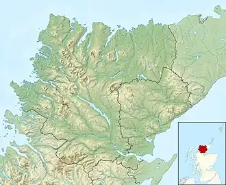
| Location | Scottish Highlands |
| Coordinates | 58°00′18.7″N 4°05′58.7″W / 58.005194°N 4.099639°W |
| Primary outflows | Allt Loch an t-Salachaidh |
| Basin countries | Scotland, United Kingdom |
| Max. length | 977 m (3,205 ft) |
| Max. width | 235 m (771 ft) |
| Surface elevation | 170 m (560 ft) |
| Islands | 1 |
Loch Salachaidh is a remote mountain loch in Sutherland, Scotland, situated 1.7km east of Rogart. It sits in a bed of psammite, surrounded by peat bogs and diamicton.[1]
The loch's name likely derives from the Scottish Gaelic salach, meaning "dirty" i.e. "Dirty Loch".[2]
Loch Salachaidh was the site of a clan battle c. 1517, between the MacKays of Strathnaver and the Murrays of Abirsors, with multiple fatalities including two chieftains.[3]
A small ruined farmstead named Kinloch ("Head of the Loch") has sat at the loch's eastern end since at least the 1870s.[4] It is unclear when it was abandoned, although it may have been during the Sutherland Clearances.
References
- ^ "Digimap Discovery Service". digimap.edina.ac.uk. Retrieved 26 March 2025.
- ^ Taylor, Simon (2002). "PLACE-NAME SURVEY OF THE PARISHES OF KILMORACK, KILTARLITY & CONVINTH, AND KIRKHILL, INVERNESS-SHIRE" (PDF).
- ^ "Loch Salachaidh | Canmore". canmore.org.uk. Retrieved 26 March 2025.
- ^ "Digimap Discovery Service". digimap.edina.ac.uk. Retrieved 26 March 2025.