List of covered bridges in Massachusetts
Below is a list of covered bridges in Massachusetts. As of 2003, there were thirteen authentic covered bridges in the U.S. state of Massachusetts of which seven are historic.[1]: 60 A covered bridge is considered authentic not due to its age, but by its construction. An authentic bridge is constructed using trusses rather than other methods such as stringers, a popular choice for non-authentic covered bridges.
Bridges
| Name | Image | County | Location | Built | Length | Crosses | Ownership | Truss | Notes |
|---|---|---|---|---|---|---|---|---|---|
| Bissell Bridge[2] | 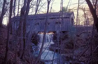
|
Franklin | Charlemont 42°37′57″N 72°52′10″W / 42.63250°N 72.86944°W |
1951, rebuilt 2009 | 94 feet (29 m) | Mill Brook | Town of Charlemont | Long through | This bridge is second covered bridge at this location, the first dating to 1880. |
| Burkeville Covered Bridge[2] | 
|
Franklin | Conway 42°29′1″N 72°42′44″W / 42.48361°N 72.71222°W |
1870-1871, rebuilt 1999 | 106 feet (32 m) | South River (Deerfield River tributary) | Town of Conway | Multiple kingrod | Also called Conway Covered Bridge |
| Creamery Bridge[1]: 68–69 | .jpg)
|
Franklin | Ashfield 42°31′11″N 72°48′3″W / 42.51972°N 72.80083°W |
1985 | 40 feet (12 m) | Creamery Brook | Private | Queen | Despite being on private land, the bridge is open to the public and houses a knickknack shop. |
| Dummerston/Vermont Bridge[1]: 77–78 | 
|
Worcester | Sturbridge 42°6′30″N 72°5′55″W / 42.10833°N 72.09861°W |
1951 | 55 feet (17 m) | Arm of Quinebaug River | Old Sturbridge Village | Town | Also called Taft Bridge; located in Dummerston, Vermont prior to 1951 |
| Quinebaug River Bridge[3] | 
|
Worcester | Sturbridge 42°6′24″N 72°5′40″W / 42.10667°N 72.09444°W |
1930s, covered in 1953 | 33 feet
(10 m) |
Quinebaug River | Old Sturbridge Village | Burr | Until a flood in 1955 it served as the main entrance to Old Sturbridge Village. |
| Goodrich Bridge[1]: 72–73 | 
|
Hampden | Westfield 42°7′22″N 72°47′10″W / 42.12278°N 72.78611°W |
1965 | 40 feet (12 m) | Pond | Stanley Park | Town | It carries pedestrian traffic across the Duck Pond, a spring-fed pond that is located in the center of Stanley Park. |
| Grays Sugarhouse Bridge[1]: 69–70 | 
|
Franklin | Ashfield 42°32′43″N 72°46′50″W / 42.54528°N 72.78056°W |
1994 | 20 feet (6.1 m) | Tributary of Bear River | Private | King | It was designed by private contractor and Scoutmaster Dwight Scott in 1994 and built with the assistance of his Boy Scout troop. |
| Green River Pumping Station Bridge[1]: 71–72 | 
|
Franklin | Greenfield 42°38′47″N 72°37′13″W / 42.64639°N 72.62028°W |
1972 | 94 feet (29 m) | Green River | State of Massachusetts | Howe | Also called Eunice Williams Bridge |
| Old Covered Bridge[2] | 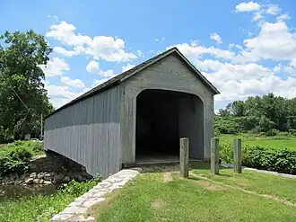
|
Berkshire | Sheffield 42°7′26″N 73°21′17″W / 42.12389°N 73.35472°W |
1837-1838, 1854, rebuilt 1998 | 93 feet (28 m) | Housatonic River | Town of Sheffield | Town | Also called Upper Sheffield/Sheffield Bridge; original bridge burned in 1994 |
| Sawyer Pond Bridge[1]: 62–63 | Essex | Magnolia 42°35′29″N 70°43′8″W / 42.59139°N 70.71889°W |
1983 | 40 feet (12 m) | Sawyer Pond | Private | Town | ||
| Arthur A. Smith Covered Bridge[2] | 
|
Franklin | Colrain 42°40′12″N 72°43′9″W / 42.67000°N 72.71917°W |
1868, 1870, 1896, rebuilt 2006 | 98 feet (30 m) | North River | Town of Colrain | Burr | Originally erected further downstream about 1870, the bridge was moved to the Lyonsville Road crossing of the East Branch of the North River in 1886 |
| Ware-Hardwick Covered Bridge[2] | 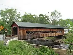
|
Hampshire and Worcester | Hardwick, Ware 42°18′37″N 72°12′45″W / 42.31028°N 72.21250°W |
1886, rebuilt 1986 | 137 feet (42 m) | Ware River | Towns of Ware and Hardwick | Town | Also called Gilbertville/Ware Bridge |
| Chester/Charles H. Waterous Bridge[1]: 75–76 | 
|
Middlesex | East Pepperell 42°40′10″N 71°34′30″W / 42.66944°N 71.57500°W |
1848, rebuilt 1962 and 2010 | 108 feet (33 m) | Nashua River | Town of Pepperell | Pratt variation | Also called Nehemiah Jewett's Bridge and Pepperell Bridge |
See also
- List of bridges on the National Register of Historic Places in Massachusetts
- List of covered bridges in the United States
- World Guide to Covered Bridges
References
- ^ a b c d e f g h Evans, Benjamin D. and June R. (2004). New England's Covered Bridges. Lebanon, NH: University Press of New England. pp. 57-78. ISBN 1-58465-320-5.
- ^ a b c d e "National Register Information System". National Register of Historic Places. National Park Service. July 9, 2010.
- ^ "Quinebaug River Bridge". Old Sturbridge Village. Retrieved August 3, 2025.
Further reading
Burk, John S. (2010). Massachusetts Covered Bridges. Charleston, South Carolina: Arcadia Publishing. ISBN 978-0-73857323-6.
External links
Wikimedia Commons has media related to Covered bridges in Massachusetts.
- National Society for the Preservation of Covered Bridges
- Visit Massachusetts article about the state's covered bridges