Lhotka (Ostrava)
Lhotka | |
|---|---|
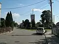
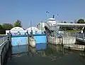
 View towards Lhotka | |
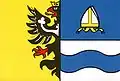 Flag 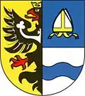 Coat of arms | |
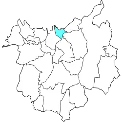 Location of Lhotka in Ostrava | |
| Coordinates: 49°51′21″N 18°13′59″E / 49.85583°N 18.23306°E | |
| Country | |
| Region | Moravian-Silesian |
| Municipality | Ostrava |
| Area | |
• Total | 2.14 km2 (0.83 sq mi) |
| Population (2021)[1] | |
• Total | 1,333 |
| • Density | 620/km2 (1,600/sq mi) |
| Time zone | UTC+1 (CET) |
| • Summer (DST) | UTC+2 (CEST) |
| Postal code | 725 28 |
| Website | lhotka |
Lhotka is a borough and municipal part of the city of Ostrava in the Czech Republic. It is situated in the northern part of the city, on the left bank of the Oder River. It was a separate municipality until April 1976, when it merged with Ostrava.[2] On 24 November 1990, it became one of the 23 self-governing boroughs of Ostrava.[3]
Etymology
The word lhotka is a diminutive form of the word lhota (or lhóta), which comes from the Old Czech word for lhůta, meaning 'period' or 'grace period'. When new settlements were established in areas with less fertile soil, settlers were often granted a temporary exemption from taxes for a specific period of time.[4]
Gallery
References
- ^ "Results of the 2021 Census - Open data". Public Database (in Czech). Czech Statistical Office. 27 March 2021.
- ^ "Historie Lhotky". City of Ostrava. Retrieved 7 July 2025.
- ^ "Ostravské městské obvody". eOstrava.cz (in Czech). Retrieved 6 July 2025.
- ^ Štěpánová, Veronika (12 January 2025). "Jak české Lhoty ke svým názvům přišly. Jejich obyvatelé jsou na název náležitě hrdí". Lidovky.cz. Retrieved 7 July 2025.