Krasnoshchelye
Krasnoshchelye
Краснощелье | |
|---|---|
 | |
Location of Krasnoshchelye | |
 Krasnoshchelye Location of Krasnoshchelye 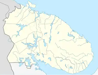 Krasnoshchelye Krasnoshchelye (Murmansk Oblast) | |
| Coordinates: 67°20′0″N 37°1′59″E / 67.33333°N 37.03306°E | |
| Country | Russia |
| Federal subject | Murmansk Oblast[1] |
| Administrative district | Lovozersky District[1] |
| Founded | 1921 |
| Elevation | 157 m (515 ft) |
| Population | |
• Total | 423 |
| Time zone | UTC+3 (MSK |
| Postal code(s)[4] | 184595 |
| Dialing code(s) | +7 81538[5] |
| OKTMO ID | 47610401111 |
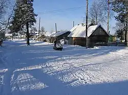
Krasnoshchelye (Russian: Краснощелье)[a] is a rural locality (a Selo) in Lovozersky District of Murmansk Oblast, Russia. The village is located beyond the Arctic Circle, on the Kola Peninsula. It is 157 m above sea level.
Krasnoshchelye was established in the 1920s by Izhma Komi people, who make up most of its population today. Sámi people also live in the settlement.[8]
The film "The Tundra Race" by German director René Harder portrays the village and its inhabitants. The documentation was launched at the Locarno International Film Festival in 2013.[9]
History
Krasnoshchelye was established by Komi people from the Pechora basin around 1920. Three other Komi villages existed nearby: Ivanovka (Chalmny-Varre) founded in 1917, Oksino founded in 1920 and Kanevka founded in 1923.[6] According to the census of 1926–1927, Krasnoshchelye had 14 households and 78 inhabitants, of whom 62 were Komi and 16 were Nenets. The villagers were engaged in reindeer herding and fishing.[10]
A reindeer herding kolkhoz was established in 1933. At the time, there were 17 families in Krasnoshchelye, of whom 13 were Komi, 2 were Sámi and 2 were Nenets.[10] By 1966, the population had increased to 700 after the residents of Ivanovka, Kamenka and Ponoy were resettled in Krasnoshchelye.[11]
Climate
| Climate data for Krasnoshchelye (extremes 1932–present) | |||||||||||||
|---|---|---|---|---|---|---|---|---|---|---|---|---|---|
| Month | Jan | Feb | Mar | Apr | May | Jun | Jul | Aug | Sep | Oct | Nov | Dec | Year |
| Record high °C (°F) | 4.6 (40.3) |
5.1 (41.2) |
9.3 (48.7) |
17.1 (62.8) |
27.9 (82.2) |
31.7 (89.1) |
33.9 (93.0) |
31.7 (89.1) |
24.4 (75.9) |
13.7 (56.7) |
8.4 (47.1) |
6.4 (43.5) |
33.9 (93.0) |
| Mean daily maximum °C (°F) | −8.5 (16.7) |
−8.4 (16.9) |
−3.4 (25.9) |
2.0 (35.6) |
8.1 (46.6) |
15.1 (59.2) |
19.1 (66.4) |
15.8 (60.4) |
10.5 (50.9) |
2.8 (37.0) |
−2.9 (26.8) |
−5.5 (22.1) |
3.7 (38.7) |
| Daily mean °C (°F) | −12.5 (9.5) |
−12.3 (9.9) |
−8.1 (17.4) |
−2.3 (27.9) |
3.8 (38.8) |
10.0 (50.0) |
13.9 (57.0) |
11.2 (52.2) |
6.7 (44.1) |
0.4 (32.7) |
−5.7 (21.7) |
−8.9 (16.0) |
−0.3 (31.4) |
| Mean daily minimum °C (°F) | −17.3 (0.9) |
−16.9 (1.6) |
−13.4 (7.9) |
−6.9 (19.6) |
−0.4 (31.3) |
5.1 (41.2) |
8.8 (47.8) |
6.9 (44.4) |
3.1 (37.6) |
−2.3 (27.9) |
−9.0 (15.8) |
−12.9 (8.8) |
−4.6 (23.7) |
| Record low °C (°F) | −44.7 (−48.5) |
−48.8 (−55.8) |
−41.7 (−43.1) |
−34.1 (−29.4) |
−19.0 (−2.2) |
−4.6 (23.7) |
−1.6 (29.1) |
−4.3 (24.3) |
−11.1 (12.0) |
−26.2 (−15.2) |
−34.3 (−29.7) |
−44.0 (−47.2) |
−48.8 (−55.8) |
| Average precipitation mm (inches) | 33.2 (1.31) |
29.0 (1.14) |
29.4 (1.16) |
28.8 (1.13) |
47.4 (1.87) |
59.6 (2.35) |
68.2 (2.69) |
71.1 (2.80) |
49.5 (1.95) |
54.7 (2.15) |
38.5 (1.52) |
39.5 (1.56) |
548.9 (21.63) |
| Source: pogoda.ru.net[12] | |||||||||||||
Notes
- ^ Komi: Гöрд щелья;[6] Kildin Sami: Кра̄снэ сыййт[7]
References
- ^ a b c d OKATO, Part 2. Code 47 210 000 001
- ^ Статистический сборник Численность, размещение и возрастно-половой состав населения Мурманской области. Итоги Всероссийской переписи населения. Том 1. 2012 / Федеральная служба государственной статистики, Территориальный орган Федеральной службы государственной статистики по Мурманской области. Мурманск, 2012 — 75 с.
- ^ "Об исчислении времени". Официальный интернет-портал правовой информации (in Russian). 3 June 2011. Retrieved 19 January 2019.
- ^ Russian Post. Эталонный справочник индексов объектов почтовой связи Archived 2007-01-12 at the Wayback Machine (in Russian)
- ^ Народная энциклопедия городов и регионов России «Мой Город» (in Russian)
- ^ a b Turkin, Adolf (1994). "О взаимоотношениях коми и саамского языков" [On the relationship between Komi and Sámi languages]. Linguistica Uralica (in Russian). 30: 2–3. doi:10.3176/lu.1994.1.03.
- ^ Afanasyeva, Nina Eliseyevna (2020). Сказ о саамском флаге [Story of the Sámi flag] (digital version) (in Russian and Kildin Sami). Murmansk: self-published. pp. 7, 19. Retrieved 5 August 2025.
- ^ Pineda, David (2008). "Куэссь не получается сāмас, рyшас полегче"–codeswitching on the Kola Peninsula". Poljarnyj Vestnik. 11: 2. doi:10.7557/6.1301.
- ^ "German Documentaries - home".
- ^ a b 100 лет селу Краснощелье : 1921-2021 [100 years of Krasnoshchelye village] (PDF) (digital version) (in Russian). Revda: МБУ «Ловозерская межпоселенческая библиотека». 2021. pp. 5–6. Retrieved 5 August 2025.
- ^ "КРАСНОЩЕЛЬЕ селение". «Кольский Север». Энциклопедический лексикон (in Russian). Доброхот. 2013. Retrieved 5 August 2025.
- ^ "Климат Краснощелья" (in Russian). Retrieved 27 December 2022.