Krapina-Zagorje County
Krapina-Zagorje County
Krapinsko-zagorska županija (Croatian) | |
|---|---|
.jpg) 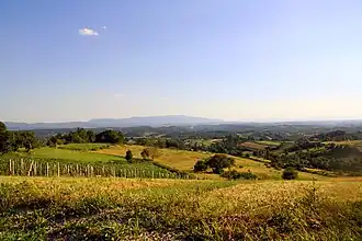 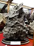 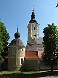 .jpg) 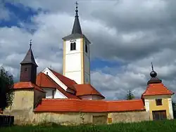 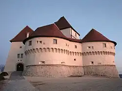 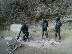 .jpg) | |
 Flag  Coat of arms | |
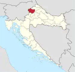 Krapina-Zagorje County within Croatia | |
| Country | Croatia |
| County seat | Krapina |
| Government | |
| • Župan (Prefect) | Željko Kolar (SDP) |
| • Assembly | 41 members |
| Area | |
• Total | 1,229 km2 (475 sq mi) |
| Population (2021)[2] | |
• Total | 120,702 |
| • Density | 98/km2 (250/sq mi) |
| Area code | 049 |
| ISO 3166 code | HR-02 |
| HDI (2022) | 0.836[3] very high · 16th |
| Website | www |
Krapina-Zagorje County (pronounced [krâpina zǎːɡɔːrje], Croatian: Krapinsko-zagorska županija) is a county in northern Croatia, bordering Slovenia. It encompasses most of the historic region called Hrvatsko Zagorje.
The area contains the excavation site of a 100,000-year-old Neanderthal man in caves near the central town of Krapina. The existence of Krapina itself has been verified since 1193, and it has been a common site for castles and other country houses of Croatian, Austrian and Hungarian rulers.
Other towns of the county are Zabok, Pregrada, Zlatar, Oroslavje, Donja Stubica, Klanjec. The town of Stubica features another thermal spring, the Stubičke spa. Also in the area are the medieval castles Veliki Tabor, Miljana, Bežanec, Hellenbach, Milengrad etc.
Krapina-Zagorje County borders on Varaždin County in the northeast, Zagreb County in the southwest and southeast, and the city of Zagreb in the south. The county contains many vineyards. 15% of the year, fog significantly lowers visibility in the area.
Administrative division
Krapina-Zagorje County is divided into 7 towns or cities, 25 municipalities and 422 settlements:[4]
- Town of Krapina (county seat)
- Town of Donja Stubica
- Town of Klanjec
- Town of Oroslavje
- Town of Pregrada
- Town of Zabok
- Town of Zlatar
- Municipality of Bedekovčina
- Municipality of Budinščina
- Municipality of Desinić
- Municipality of Đurmanec
- Municipality of Gornja Stubica
- Municipality of Hrašćina
- Municipality of Hum na Sutli
- Municipality of Jesenje
- Municipality of Konjščina
- Municipality of Kraljevec na Sutli
- Municipality of Krapinske Toplice
- Municipality of Kumrovec
- Municipality of Lobor
- Municipality of Mače
- Municipality of Marija Bistrica
- Municipality of Mihovljan
- Municipality of Novi Golubovec
- Municipality of Petrovsko
- Municipality of Radoboj
- Municipality of Stubičke Toplice
- Municipality of Sveti Križ Začretje
- Municipality of Tuhelj
- Municipality of Veliko Trgovišće
- Municipality of Zagorska Sela
- Municipality of Zlatar Bistrica
Demographics

|
| |||||||||||||||||||||||||||||||||||||||||||||||||||||||||
| Source: Naselja i stanovništvo Republike Hrvatske 1857–2001, Croatian Bureau of Statistics, Zagreb, 2005 | ||||||||||||||||||||||||||||||||||||||||||||||||||||||||||
Since the late 1940s the county's population has been slowly shrinking. As of the 2021 census, the county had 120,702 residents. The population density is 98 people per km2. Of the 120,702 residents, 61,925 were female and 58,777 were male.[2]
| population | 100804 | 113711 | 125394 | 139547 | 152047 | 168404 | 163594 | 175227 | 181586 | 178938 | 168952 | 161247 | 153567 | 148779 | 142432 | 132892 | 120942 |
| 1857 | 1869 | 1880 | 1890 | 1900 | 1910 | 1921 | 1931 | 1948 | 1953 | 1961 | 1971 | 1981 | 1991 | 2001 | 2011 | 2021 |
Ethnic Croats form the majority with 97.89% of the population, followed by Slovenes (0.31%) and Serbs (0.13%), with other ethnicities making up the rest.[2]
Administration
The current prefect of Krapina-Zagorje County is Željko Kolar (SDP) and the Krapina-Zagorje County Assembly consists of 37 seats.
| Groups | Members per group | ||||||||||||||||||||||||||||
| SDP-HSS-Reformists | 22 / 37
| ||||||||||||||||||||||||||||
| HDZ-HSU | 11 / 37
| ||||||||||||||||||||||||||||
| Independents | 4 / 37
| ||||||||||||||||||||||||||||
| Source:[5] | |||||||||||||||||||||||||||||
References
- ^ Ostroški, Ljiljana, ed. (December 2015). Statistički ljetopis Republike Hrvatske 2015 [Statistical Yearbook of the Republic of Croatia 2015] (PDF). Statistical Yearbook of the Republic of Croatia (in Croatian and English). Vol. 47. Zagreb: Croatian Bureau of Statistics. p. 62. ISSN 1333-3305. Retrieved 27 December 2015.
- ^ a b c "Population by Age and Sex, by Settlements" (xlsx). Census of Population, Households and Dwellings in 2021. Zagreb: Croatian Bureau of Statistics. 2022.
- ^ "Sub-national HDI - Area Database - Global Data Lab". hdi.globaldatalab.org. Retrieved 2024-10-10.
- ^ "2-2. Županije, površina, stanovništvo, gradovi, općine i naselja (teritorijalni ustroj prema stanju 31. prosinca 2017.) - Statistički ljetopis Republike Hrvatske 2018" [2-2. Counties, surface area, population, towns, municipalities and settlements (territorial constitution with situation as on 31 December 2017) - Statistical Yearbook of the Republic of Croatia 2018] (PDF). Croatian Bureau of Statistics. December 2018. Archived from the original (PDF) on 21 March 2022. Retrieved 10 May 2019.
- ^ "II. KRAPINSKO-ZAGORSKA ŽUPANIJA" (PDF). State Election Committee of the Republic of Croatia. Retrieved 26 July 2025.
External links
- Official website
 (in Croatian)
Subdivisions of | ||
|---|---|---|
| Towns | | |
| Municipalities |
| |