Kožuchovce
Kožuchovce | |
|---|---|
 | |
 Flag  Coat of arms | |
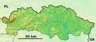 Kožuchovce Location of Kožuchovce in the Prešov Region  Kožuchovce Location of Kožuchovce in Slovakia | |
| Coordinates: 49°19′N 21°42′E / 49.32°N 21.70°E | |
| Country | |
| Region | |
| District | Stropkov District |
| First mentioned | 1618 |
| Area | |
• Total | 6.15 km2 (2.37 sq mi) |
| Elevation | 340 m (1,120 ft) |
| Population (2021)[3] | |
• Total | 48 |
| Time zone | UTC+1 (CET) |
| • Summer (DST) | UTC+2 (CEST) |
| Postal code | 902 2[2] |
| Area code | +421 54[2] |
| Car plate | SP |
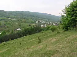
Kožuchovce (Rusyn: Кожухівцї; Hungarian: Körmös) is a village and municipality in Stropkov District in the Prešov Region of north-eastern Slovakia.
History
In historical records the village was first mentioned in 1618.
Geography
The municipality lies at an altitude of 340 metres and covers an area of 6.15 km2. It has a population of about 48 people.
References
- ^ "Hustota obyvateľstva - obce [om7014rr_ukaz: Rozloha (Štvorcový meter)]". www.statistics.sk (in Slovak). Statistical Office of the Slovak Republic. 31 March 2022. Retrieved 31 March 2022.
- ^ a b c "Základná charakteristika". www.statistics.sk (in Slovak). Statistical Office of the Slovak Republic. 17 April 2015. Retrieved 31 March 2022.
- ^ "Počet obyvateľov podľa pohlavia - obce (ročne)". www.statistics.sk (in Slovak). Statistical Office of the Slovak Republic. 31 March 2022. Retrieved 31 March 2022.