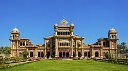
Khairpur (princely state)
Khairpur state ریاست خیرپور | |||||||||||
|---|---|---|---|---|---|---|---|---|---|---|---|
| 1783–30 September 1955 | |||||||||||
 Flag | |||||||||||
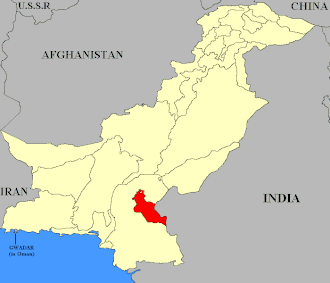 Khairpur (highlighted red) shown within the former exclave of West Pakistan | |||||||||||
| Status | Princely state under British Raj(1838-1947) Princely state of Pakistan (1947-1955) | ||||||||||
| Capital | Khairpur | ||||||||||
| Common languages | Sindhi | ||||||||||
| Religion | Islam | ||||||||||
| Government | Absolute Monarchy | ||||||||||
| Mir | |||||||||||
• 1783–1811 | Mir Sohrab Khan Talpur (first) | ||||||||||
• 1947–1954 | George Ali Murad Khan Talpur II (last) | ||||||||||
| History | |||||||||||
| 1783 | |||||||||||
| 17 February – 24 March 1843 | |||||||||||
• Princely State established | c. 1853 | ||||||||||
| 3 October 1947 | |||||||||||
| 30 September 1955 | |||||||||||
| Area | |||||||||||
• Total | 15,730 km2 (6,070 sq mi) | ||||||||||
| |||||||||||
| Today part of | |||||||||||
 |
| This article is part of the series |
| Former administrative units of Pakistan |
|---|
The State of Khairpur (also transliterated as Khayrpur)[1] was a princely state of British India on the Indus River in northern Sindh, modern Pakistan, with its capital city at Khairpur.
History
Khairpur was established by the Talpur dynasty of the Balochs in 1783. Conquered by the British in 1843 following the Battle of Miani, Mir Sher Muhammad Talpur eventually gave up attempts to regain control of the area after a decade and entered into treaty with the British, thereby maintaining some autonomy as a princely state. The last Mir of Khairpur opted to join the new state of Pakistan in 1947, and the dominion was thus made a princely state of Pakistan, until it was fully amalgamated into West Pakistan in 1955.[2]
%252C_published_in_the_'Imperial_Gazetteer_of_India'_(Vol._XXVI%252C_Atlas%253B_1931_revised_edition%253B_plate_no._38).jpg)
See also
References
- ^ "Imperial Gazetteer2 of India, Volume 3, page 336 -- Imperial Gazetteer of India -- Digital South Asia Library". dsal.uchicago.edu. Archived from the original on 4 March 2016. Retrieved 5 August 2011.
- ^ "Khairpur: then and now - Daily Times". Daily Times. 6 February 2018. Archived from the original on 8 October 2019. Retrieved 16 May 2018.