Khadir Bet
.jpg) Satellite image showing the Thar Salt Desert (center), Gujarat Solar Park (center-bottom), and Khadir Bet (bottom-left) | |
 Khadir Bet Location in Gujarat, India | |
| Geography | |
|---|---|
| Location | Great Rann of Kutch, Gujarat, India |
| Coordinates | 23°51′41″N 70°19′45″E / 23.86139°N 70.32917°E |
| Area | 200 km2 (77 sq mi) |
| Highest elevation | 125 m (410 ft) |
| Administration | |
India | |
| State | Gujarat |
| District | Kutch |
Khadir Bet is an island located in the Great Rann of Kutch in Gujarat, India. It spans around 200 square kilometers. It is known for its archaeological significance, particularly as the site of the ancient Indus Valley Civilization city of Dholavira, also a UNESCO[1] world heritage site.[2][3]
The term "Khadir" is derived from the Kutchi word "Khad", which translates to "grass".[4] In 2022, a new 24.5 km road connecting Khadir Bet to Bhachau Taluka was sanctioned by the government, reducing travel distance and improving accessibility to the Dholavira World Heritage Site.[5]
Geography
It lies in the Great Rann of Kutch, approximately 5 kilometers from the mainland. Khadir Bet is triangular, with sharp cliffs on its northern edge rising up to 125 meters, while the southern part slopes gently into the surrounding salt flats. The southern part slopes gently into the surrounding salt flats. The geology of Khadir Island consists mainly of sandstones, claystone, and fossiliferous limestone, with cultivable soil in some areas.[2]
In July 2023, researchers from the Gujarat Ecological Education and Research Foundation (GEERF) documented the presence of Salsola oppositifolia, a halophytic (salt-tolerant) shrub typically found around the Mediterranean Sea, including regions of Italy and Northern Africa, for the first time in India at Khadir Bet.[6]
Archaeology
Khadir Bet is best known for its connection to Dholavira, an ancient city of the Indus Valley Civilization. The Harappans extracted over three million cubic meters of earth and rock from the island, which were used in construction, pottery, and artifact production for both local use and export.[2]
Apart from Dholavira, several other archaeological sites have been identified on Khadir Bet. One notable site is Jhandiasar, located about 2 kilometers north of Dholavira, near a seasonal rivulet. This site reveals remnants of stone structures, such as walls and square formations, indicating it might have functioned as a harbor or logistical base for transporting materials to Dholavira. Another site, Bambhanka, located about 15 kilometers south of Dholavira, situated on a high tableland near a seasonal stream that flows into the sea.[2]
Recent prehistoric findings
In 2025, a collaborative archaeological study led by the Indian Institute of Technology Gandhinagar (IITGN), along with researchers from IIT Kanpur, the Inter-University Accelerator Centre (IUAC), and the Physical Research Laboratory (PRL), identified prehistoric shell-midden sites on Khadir Bet and neighboring islands in the Rann of Kutch. Radiocarbon dating using Accelerator Mass Spectrometry (AMS) placed these deposits at approximately 10,000 BCE, significantly earlier than the Harappan settlement of the region.[7][8]
The sites contained large accumulations of mollusc shells (including oysters and gastropods), along with lithic (stone) tools and flaking debris from tool production, suggesting habitation by coastal foraging communities. These findings point to human presence in the Kutch region during the terminal Pleistocene to early Holocene period. The sites show signs of repeated or prolonged use over time. The research proposes that such early communities were adapted to mangrove-rich coastal ecologies, and the presence of tool-making debris indicates on-site subsistence activity.[7]
This research adds to the archaeological record of the region by indicating human presence in Kutch several millennia before the development of Harappan urban centres such as Dholavira. Similar coastal foraging patterns have also been recorded in coastal sites of present-day Pakistan and the Arabian Peninsula.[7]
Gallery
-
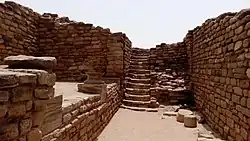
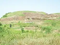 Dholavira, Khadir Bet
 -
.jpg) Fruit vendors
Fruit vendors -
 A bird
See also
References
- ^ "Dholavira: The lost-found civilisation". Deccan Herald. October 29, 2021.
- ^ a b c d Gaur, A.S.; Murali, R. Mani (November 2019). "Looking for the Harappan Ports around Dholavira, Khadir Bet, Kachchh, Gujarat" (PDF). Indian Journal of Geo Marine Sciences. 48 (11). Council of Scientific and Industrial Research, National Institute of Oceanography, India: 1769-1773.
- ^ "Best Laid Plans". Deccan Herald. 2019-04-05.
- ^ "News in Frames: Connecting Dholavira". The Hindu. 2022-03-10.
- ^ "વહીવટી મંજુરી:એકલ-બાંભણકા વચ્ચે રસ્તો બનતા ખડીરના વિકાસના નવા દ્વાર ખુલશે" (in Gujarati). Divya Bhaskar. 2022-07-17.
- ^ "Mediterranean halophyte discovered in Khadir Bet". The Times of India. 2023-07-29.
- ^ a b c "Shell Chronicles of Ancient Kachchh". www.pib.gov.in. Archived from the original on 2025-07-03. Retrieved 2025-07-17.
- ^ "Kutch Pre-Harappan Discovery: Human Habitation Dates Back 5,000 Years". Deccan Herald. Retrieved 2025-07-17.