Katsura River
| Katsura River | |
|---|---|
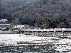 The Togetsukyo Bridge | |
|
| |
| Native name | 桂川 (Japanese) |
| Location | |
| Country | Japan |
| Physical characteristics | |
| Mouth | |
• location | Yodo River |
| Length | 107 km (66 mi) |
| Basin size | 1,159 km2 (447 sq mi) |
| Basin features | |
| River system | Yodo River |
The Katsura River (桂川, Katsura-gawa) is a tributary of the Yodo River in the Kyoto Prefecture, Honshu island, Japan.[1]
Traditionally it was regarded as the Western border of Kyoto city (in the East it was the Kamo River).[2]
The river rises near the Sasari mountain pass, close to the city of Nantan.[1]
It emerges from the mountains and expands into a shallow, slow-flowing river until Togetsukyo Bridge in Arashiyama.[3] From that point forward, the river is referred to as the Katsura River, and its flow continues for several kilometers through Kyoto Prefecture until it joins the Kamo and Uji rivers.
The Katsura River area features some of the oldest shrines in Kyoto and Japan, such as Matsuo Shrine, and, as a counterpoint to the channelled Kamo River, supports acres of agricultural area on its flood plain. It also is known for its summer supply of ayu.
See also
References
- ^ a b "桂川". 日本の川 (in Japanese). MLIT Japan. 2008. Archived from the original on 2021-09-20. Retrieved 2021-08-24.
- ^ "Kamo river, Japan". Archived from the original on 2021-08-25. Retrieved 2021-08-25.
- ^ "Togetsu-kyo Bridge". Kyoto City Tourism Association. Retrieved 14 November 2020.
External links
34°52′50″N 135°40′41″E / 34.880548°N 135.678056°E (confluence with Kizu River and Uji River)
| |||||||||||||||
| |||||||||||||||
| |||||||||||||||
| |||||||||||||||
| |||||||||||||||