Karanja, Wardha
Karanja (Ghadge) | |
|---|---|
Tehesil town | |
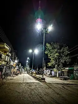 Golibar Chowk at Karanja(gh) | |
 Karanja (Ghadge) Map showing location of Karanja (gh)  Karanja (Ghadge) Karanja (Ghadge) (India) | |
| Coordinates: 21°9′39.47″N 78°24′32.76″E / 21.1609639°N 78.4091000°E | |
| Country | |
| State | Maharashtra |
| Region | Vidarbha |
| District | Wardha |
| Total villages in Tehsil | 121 |
| Government | |
| • Type | Nagar panchayat |
| • Body | Karanja Nagar panchayat |
| Population (2011[1]) | |
• Total | 90,462 |
| Languages | |
| • Official | Marathi |
| • Other Languages | Hindi, English, Gujrati, Sindhi |
| Time zone | UTC+5:30 (IST) |
| Telephone code | 91-7156 |
| Vehicle registration | MH- 32 (Wardha District) |
| Website | under construction |
Karanja (Ghadge) is a tehsil town located within the Arvi subdivision and serves as a taluka (code 4961) in the Wardha district of Maharashtra, India.
Governance
The tehsil comprises around 60 gram panchayats and 102 villages.[2] In 2015, Karanja was designated as a Nagar Panchayat.
Demographics
The majority of the population in Karanja consists of Hindus, with significant communities of Buddhists and Muslims also residing in the area.[3]
Agriculture
Karanja (Ghadge) and its surrounding areas are known for producing oranges, cotton, and soybean.
Transport
Karanja is located on National Highway 53 (India), also known as Asian Highway (AH46) or National Highway 6 (India, under the old numbering system). It is approximately 76 km from Nagpur, 75 km from Amravati, and 70 km from Wardha, placing it almost at the center of these major cities. Due to its strategic location, it serves as a convenient rest stop for tourists, travelers, and transport services.
References
- ^ "Wardha District Census 2011". Retrieved 21 January 2023.
- ^ "Subdivision & Blocks". Retrieved 21 January 2023.
- ^ "Wardha District Census 2011". Retrieved 21 January 2023.
Wardha district topics | ||
|---|---|---|
| History | .svg.png) | |
| Geography | ||
| Cities and towns | ||
| Education | ||
| Transport | ||
| Lok Sabha constituencies | ||
| Vidhan Sabha constituencies | ||
| Topics | |||||||||||||
|---|---|---|---|---|---|---|---|---|---|---|---|---|---|
| Regions | |||||||||||||
| Divisions and Districts |
| ||||||||||||
| Million-plus cities in Maharashtra | |||||||||||||
| Other cities with municipal corporations | |||||||||||||
| Government | |||||||||||||