Kapiapia Rock
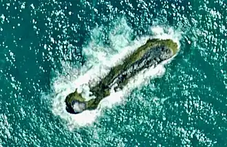 Aerial view of Kapiapia Rock | |
Location of Kapiapia Rock | |
| Geography | |
|---|---|
| Location | Tasman Sea, Waikato region |
| Coordinates | 37°32′25″S 174°43′39″E / 37.54030°S 174.72761°E |
| Highest elevation | 17 m (56 ft) |
| Administration | |
New Zealand | |
Kapiapia Rock is a tiny island about 3 kilometres (1.9 miles) offshore from Waikaretu, on the Waikato coast of New Zealand's North Island. It is less than 20 metres (66 ft) above sea level.[1]
The rock is formed of Pliocene Ngatutura basalt, part of the Ngatutura volcanic field.[2] The island has sometimes been called Black Rock.[3]
Birds nesting on the rock include Black shags (kawau) Phalacrocorax carbo, Spotted shags (pārekareka) Stictacarbo punctatus, New Zealand pipit (pīhoihoi) Anthus novaeseelandiae and Dunnock (hedge sparrow) Prunella modularis[4] and molluscs on the rock include limpets (ngakihi) Notoacmea scopulina.[5]
The rock is associated with a legend about local weather, the brothers Rakapawhara and Te Atai-o-rongo and revenge by the latter's son, Kaihu, after a fishing trip near the rock had ended in his father's death.[6][7][8]
See also
References
- ^ "Kapiapia Rock, Waikato". NZ Topo Map. Retrieved 26 July 2025.
- ^ "Geological map of Coast and Awaroa". natlib.govt.nz. 1925. Retrieved 26 July 2025.
- ^ "Raglan. Waikato Times". paperspast.natlib.govt.nz. 9 January 1886. Retrieved 26 July 2025.
- ^ "Classified summarised notes" (PDF). birds.nz. 1979.
- ^ "NZ Mollusca - Notoacmea scopulina". mollusca.co.nz. Retrieved 26 July 2025.
- ^ "Maori memories. Kawhia Settler and Raglan Advertiser". paperspast.natlib.govt.nz. 17 February 1933. Retrieved 26 July 2025.
- ^ "Maori memories. Kawhia Settler and Raglan Advertiser". paperspast.natlib.govt.nz. 3 March 1933. Retrieved 26 July 2025.
- ^ Collection, R. N. Z.; Te Huia, Raureti. "[Ētahi kōrero mō Tainui waka]". DigitalNZ. Retrieved 26 July 2025.
37°32′25″S 174°43′39″E / 37.54030°S 174.72761°E