Kamýk (Prague)
Kamýk | |
|---|---|
Municipal District of Prague Cadastral Area of Prague | |
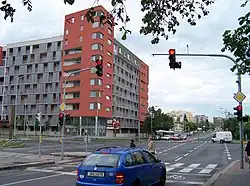 Novodvorská street in Kamýk | |
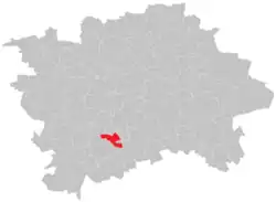 Location of Kamýk in Prague | |
| Coordinates: 50°00′55″N 14°26′18″E / 50.0153°N 14.4383°E | |
| Country | Czech Republic |
| Region | Prague, the Capital City |
| Area | |
• Total | 2.54 km2 (0.98 sq mi) |
| Population (2021)[1] | |
• Total | 19,129 |
| • Density | 7,500/km2 (20,000/sq mi) |
| Time zone | UTC+1 (CET) |
| • Summer (DST) | UTC+2 (CEST) |
| Postal code | 142 00 and 143 00 |
Kamýk is a city part and cadastral area in Prague, Czech Republic. It is situated in the southern part of the city, and is part of the administrative district Prague 12 in the municipal district Prague 4.[2][3] It is named after a local forest of the same name,[4] the word kamýk is derived from the Czech word kámen, meaning stone.[5]
References
- ^ "Results of the 2021 Census - Open data". Public Database (in Czech). Czech Statistical Office. 2021-03-27.
- ^ "Developer uspěl s návrhem výškových budov v pražském Kamýku - Novinky". www.novinky.cz (in Czech). 2023-05-01. Retrieved 2025-07-20.
- ^ "Katastrální území Kamýk | GeoPas.cz". geopas.cz. Retrieved 2025-07-20.
- ^ "Kamýk". prehis.cz. Retrieved 2025-07-20.
- ^ "Místo pro život - didaktický portál | Kamýk". www.ucenibezucebnic.cz. Retrieved 2025-07-20.