Kögart
| Kögart | |
|---|---|
 | |
| Etymology | from “kök” — blue/green and ancient Kyrgyz “art” — mountain pass; meaning “blue pass” |
| Native name | |
| Location | |
| Country | Kyrgyzstan |
| Physical characteristics | |
| Mouth | |
• location | Kara Darya |
• coordinates | 40°51′29″N 72°49′32″E / 40.8581°N 72.8255°E |
| Length | 105 km (65 mi) |
| Basin size | 1,370 km2 (530 sq mi) |
| Discharge | |
| • average | 18.1 m3/s (640 cu ft/s) |
| Basin features | |
| Progression | Kara Darya→ Syr Darya→ North Aral Sea |
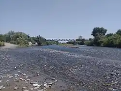
The Kögart (/ˈkoʊɡɑːrt/, Kyrgyz: [cɵˈʁɑrtʰ]) is a right tributary of the Kara Darya in Kyrgyzstan. It originates on the southwestern slopes of the Fergana Range and flows through the Kögart Valley. The river is 105 km (65 mi) long, with a drainage basin of 1,370 km2 (530 sq mi).[1][2] It flows into the Kara Darya near the town of Suzak. The river is used for irrigation.
Hydrology
Average annual discharge is 18.3 m3/s (650 cu ft/s), with seasonal variation from a minimum of 5.43 m3/s (192 cu ft/s) in January to a maximum of 58.8 m3/s (2,080 cu ft/s) in May. The river is fed by snowmelt, springs, and rainfall, with water levels typically rising in April and receding by August. [1]
Tributaries
Among major tributaries are Kyzyl-Suu, Karamart, Ürümbash, Josho, Karalma, and others.
Settlements
Settlements along the river include Munduz, Joon-Küngöy, Suzak, and others.
References
- ^ a b "Көгарт" [Kögart] (PDF). Кыргызстандын Географиясы [Geography of Kyrgyzstan] (in Kyrgyz). Bishkek. 2004. p. 197.
{{cite encyclopedia}}: CS1 maint: location missing publisher (link) - ^ "Basic hydrographic characteristics of rivers of Fergana valley". Archived from the original on 2022-08-16. Retrieved 2015-08-19.