Jaworzynka Valley
| Jaworzynka Valley | |
|---|---|
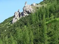
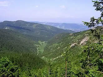 View of Jaworzynka from Przełęcz między Kopami | |
 Jaworzynka Valley | |
| Geology | |
| Type | Valley |
| Geography | |
| Country | |
| State/Province | Lesser Poland Voivodeship |
| Coordinates | 49°15′47″N 19°59′10″E / 49.26306°N 19.98611°E |
Jaworzynka is a valley in the Tatra Mountains, forming the eastern branch of Bystra Valley.[1]
Topography
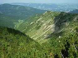
Jaworzynka branches off from Bystra Valley at Kuźnice at an elevation of 1,014 m. It is bordered to the east by Boczań and Skupniów Upłaz, to the south by Wielka Kopa Królowa, Mała Kopa Królowa, and Magura, and to the west by the northwest ridge of Magura, which includes Jaworzyńska Czuba, Zawrat Kasprowy, and Jaworzyńskie Czoła. In its upper part, the valley splits into two branches: the orographically right branch forms Długi Couloir, extending toward Przełęcz między Kopami, while the left branch is Pod Czerwienicą Couloir, cutting between the slopes of Mała Kopa Królowa and Kopa Magury.[2] On the upper slopes of Jaworzyńskie Turnie lies Magurska Cave, not accessible to tourists.[3]
On the orographically right slopes below Skupniów Upłaz, numerous rock formations and small peaks rise, including Cyganka, Cycek, Cygan, Parzące Turnie, Mnich, Krzemionka, Wołowa Turnia, and Gruba Turnia.[4] The Mnich rock formation (8 m high) is considered by Władysław Cywiński one of the most difficult to access in the Tatras, climbed by Robert Janik.[5]
Description
Carved entirely in limestone, Jaworzynka is a narrow, elongated valley resembling a gully, with steep slopes. Its lower part, where Polana Jaworzynka with shepherd huts is located, is nearly flat and level. The valley's stream, Jaworzynka, flows only after heavy rainfall due to underground drainage.[3] Stefan Żeromski wrote, "I will never forget the Jaworzynka gully under Magura until I die...", while Felicjan Medard Faleński called it "the valley of silence, shade, and serenity".[3]
The orographically right slopes feature distinctive limestone outcrops, each named due to centuries of pastoralism and mining, though these names are now largely obsolete. The left slopes, too steep for grazing or logging, have preserved significant patches of natural cliff forests.[5] Władysław Cywiński notes that Jaworzynka, despite its proximity to urban areas and heavy tourist traffic, hosts more large animals – such as red deer and chamois – than the remote, strictly protected Waksmundzka Valley or Pyszniańska Valley. Brown bears are also sighted, possibly maintaining a den in the valley.[5] Rare plants in the Polish Carpathians, including fly orchid and Rhætic pine, have been recorded here.[6][7]
History
The valley was historically a site of mining, with iron ore extraction leaving visible traces such as adits, identifiable waste rock piles, and deforested slopes. It was also a significant pastoral center in the Tatras. The entire valley, including its slopes, formed part of Hala Jaworzynka, which included Jaworzynka Polana at its base.[8] Overgrazing on the eastern slopes caused severe erosion, turning them into scree slopes. Regeneration began before World War II and continued post-war, with larch and alder – non-native to the Tatras – proving most effective due to their resilience to temperature swings (up to 60 °C daily) and windstorms compared to spruce.[5]
The valley's smooth slopes create favorable conditions for avalanches. The earliest recorded avalanche death in the Tatras relates to Jaworzynka: in 1855, 16-year-old Łukasz, son of Wacław Bukowski, died in an avalanche on Magura, likely in the Old Mine couloir.[9] Avalanches have since been recorded multiple times, including from Przełęcz między Kopami, Szerokie Couloir, Długi Couloir, and the slopes of Jaworzyńska Czuba.[9]
In 1920, Poland's first large ski jump was built on the valley's slope, with a record distance of 42 m.[3]
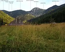
Hiking trails
- A yellow trail runs through the valley floor from Kuźnice to Przełęcz między Kopami. Time: approximately 1 h 30 min, ↓ 1 h.[2]
References
- ^ "Geoportal. Mapa lotnicza" [Geoportal. Aerial Map]. Geoportal (in Polish). Retrieved 19 June 2025.
- ^ a b Tatry Polskie. Mapa turystyczna 1:20 000 [Polish Tatras. Tourist Map 1:20,000] (in Polish). Piwniczna: WiT. 2009. ISBN 978-83-89580-00-9.
- ^ a b c d Nyka, Józef (2003). Tatry polskie. Przewodnik [Polish Tatras. Guidebook] (in Polish) (13th ed.). Latchorzew: Trawers. ISBN 83-915859-1-3.
- ^ Paryski, Witold Henryk (1952). "O nazewnictwie Tatr i Podtatrza" [On the Nomenclature of the Tatras and Podtatrze]. Wierchy (in Polish). 21. Warszawa: Kraj: 152–174.
- ^ a b c d Cywiński, Władysław (2008). Tatry. Kasprowy Wierch [Tatras. Kasprowy Wierch] (in Polish). Vol. 13. Poronin: Wydawnictwo Górskie. ISBN 978-83-7104-011-5.
- ^ Mirek, Zbigniew; Piękoś-Mirek, Halina (2008). Czerwona księga Karpat Polskich [Red Book of the Polish Carpathians] (in Polish). Warsaw: Instytut Botaniki PAN. ISBN 978-83-89648-71-6.
- ^ Wasak, Katarzyna; Drewnik, Marek (2013), Xu, Jianming; Wu, Jianjun; He, Yan (eds.), "Properties of Soil Organic Matter in Abounded Pastureland: A Case Study from the Jaworzynka Valley in the Tatra Mountains, Poland", Functions of Natural Organic Matter in Changing Environment, Dordrecht: Springer Netherlands, pp. 203–207, doi:10.1007/978-94-007-5634-2_36, ISBN 978-94-007-5633-5, retrieved 2025-06-20
- ^ Radwańska-Paryska, Zofia; Paryski, Witold Henryk (2004). Wielka encyklopedia tatrzańska [Great Tatra Encyclopedia] (in Polish). Poronin: Wydawnictwo Górskie. ISBN 83-7104-009-1.
- ^ a b Kłapa, Mieczysław (1960). "Lawiny" [Avalanches]. Wierchy (in Polish). 28. Kraków: Kraj: 127–163.