Jameson Land
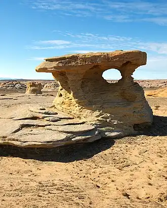 Eolian sandstone in Jameson Land | |
 Location | |
| Geography | |
|---|---|
| Location | East Greenland |
| Coordinates | 71°10′N 23°30′W / 71.167°N 23.500°W |
| Adjacent to | |
| Highest elevation | 1,444 m (4738 ft) |
| Administration | |
Greenland (Denmark) | |
| Zone | NE Greenland National Park |
Jameson Land is a peninsula in eastern Greenland.
Geography
Jameson Land is bounded to the southwest by Scoresby Sound (the world's largest fjord), to the northwest by the Stauning Alps, to the north by Scoresby Land, to the northeast by the Fleming Fjord and the Nathorst Fjord of the Greenland Sea, and to the east by Carlsberg Fjord, the smaller Liverpool Land peninsula branching off, and Hurry Inlet. Its northeastern end is Cape Biot.
The Mestersvig military base is located in the northern part of the peninsula.
Climate
Jameson Land experiences a tundra climate (Köppen: ET); with short, cool summers and long, frigid winters.[1] Temperature & humidity data within the weatherbox below was recorded from the Nerlerit Inaat Airport (2002-2020) and precipitation was sourced from Uunarteq (1958-1980).
| Climate data for Jameson Land (Nerlerit Inaat Airport) (70°20′N 22°39′W / 70.33°N 22.65°W) (14 m (46 ft) AMSL) (2002-2020 data) | |||||||||||||
|---|---|---|---|---|---|---|---|---|---|---|---|---|---|
| Month | Jan | Feb | Mar | Apr | May | Jun | Jul | Aug | Sep | Oct | Nov | Dec | Year |
| Record high °C (°F) | 15.6 (60.1) |
8.7 (47.7) |
6.3 (43.3) |
11.8 (53.2) |
11.3 (52.3) |
20.3 (68.5) |
21.7 (71.1) |
22.0 (71.6) |
12.7 (54.9) |
7.8 (46.0) |
5.2 (41.4) |
6.6 (43.9) |
22.0 (71.6) |
| Mean daily maximum °C (°F) | −10.1 (13.8) |
−11.1 (12.0) |
−11.8 (10.8) |
−6.0 (21.2) |
0.7 (33.3) |
6.7 (44.1) |
10.5 (50.9) |
10.0 (50.0) |
4.3 (39.7) |
−2.5 (27.5) |
−7.7 (18.1) |
−10.1 (13.8) |
−2.3 (27.9) |
| Daily mean °C (°F) | −14.1 (6.6) |
−15.3 (4.5) |
−15.9 (3.4) |
−9.9 (14.2) |
−2.2 (28.0) |
3.1 (37.6) |
6.7 (44.1) |
6.5 (43.7) |
1.7 (35.1) |
−4.8 (23.4) |
−10.9 (12.4) |
−13.9 (7.0) |
−5.7 (21.7) |
| Mean daily minimum °C (°F) | −18.5 (−1.3) |
−20.3 (−4.5) |
−21.4 (−6.5) |
−15.5 (4.1) |
−5.7 (21.7) |
0.2 (32.4) |
3.5 (38.3) |
3.1 (37.6) |
−1.1 (30.0) |
−7.6 (18.3) |
−14.4 (6.1) |
−18.1 (−0.6) |
−9.6 (14.7) |
| Record low °C (°F) | −38.1 (−36.6) |
−38.8 (−37.8) |
−39.1 (−38.4) |
−32.2 (−26.0) |
−20.7 (−5.3) |
−7.2 (19.0) |
−1.1 (30.0) |
−2.4 (27.7) |
−10.0 (14.0) |
−23.3 (−9.9) |
−26.7 (−16.1) |
−33.3 (−27.9) |
−39.1 (−38.4) |
| Average precipitation mm (inches) | 49 (1.9) |
39 (1.5) |
47 (1.9) |
28 (1.1) |
26 (1.0) |
24 (0.9) |
29 (1.1) |
48 (1.9) |
47 (1.9) |
65 (2.6) |
42 (1.7) |
49 (1.9) |
502 (19.8) |
| Average extreme snow depth cm (inches) | 113 (44) |
132 (52) |
159 (63) |
167 (66) |
141 (56) |
65 (26) |
12 (4.7) |
0 (0) |
4 (1.6) |
27 (11) |
62 (24) |
86 (34) |
167 (66) |
| Average precipitation days (≥ 1.0 mm) | 8.5 | 6.9 | 9.1 | 6.3 | 5.1 | 4.3 | 4.0 | 6.0 | 6.0 | 8.2 | 7.3 | 8.1 | 80.8 |
| Average snowy days | 12.0 | 10.4 | 12.8 | 9.3 | 6.7 | 3.1 | 0.4 | 1.7 | 6.5 | 11.3 | 10.7 | 11.7 | 97.0 |
| Average relative humidity (%) | 71.2 | 70.0 | 68.2 | 70.2 | 78.8 | 81.3 | 78.0 | 73.5 | 70.8 | 72.4 | 67.6 | 66.9 | 72.4 |
| Source: Danish Meteorological Institute (2002-2020 temperature & humidity)[2] (1958-1980 precipitation & snow)[3] | |||||||||||||
Geology
Jameson Land mainly consists of a tilted peneplain of Jurassic sandstone, highest in the east. In the northern end there are also rocks of Triassic age.[4] Two formations are predominant in Jameson Land: the Triassic Fleming Fjord Formation and the Jurassic Kap Stewart Formation. Triassic fossils of the Fleming Fjord Formation in Jameson Land include: the dipnoi Ceratodus,[5] prosauropod and theropod dinosaurs bones and tracks, sauropod tracks,[6] phytosaurs, temnospondyls, and sharks.[7]
-
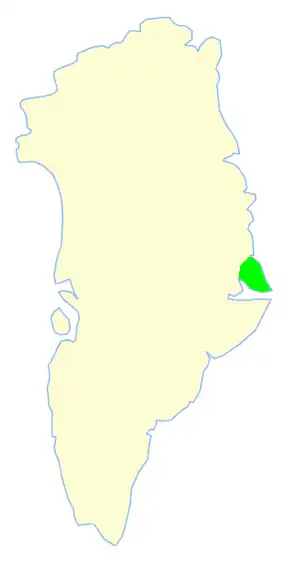
 Map of Greenland section
 -
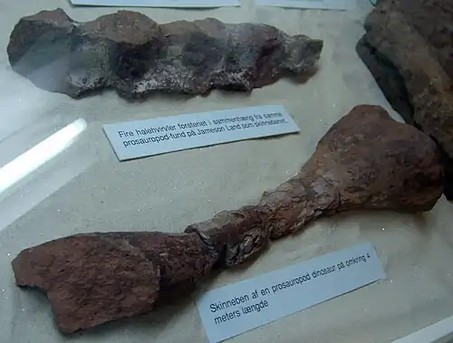 Tail vertebrae and tibia of a 4 meter long prosauropod dinosaur from Jameson Land, at the Geological Museum in Copenhagen
See also
References
- ^ Beck, Hylke E; McVicar, Tim R; Vergopolan, Noemi; et al. (October 23, 2023). "High-resolution (1 km) Köppen-Geiger maps for 1901–2099 based on constrained CMIP6 projections". Nature. Retrieved August 14, 2025.
- ^ Cappelen, J; Drost Jensen, C; Laursen, Ellen Vaarby; Stannius, Lotte Sligting; Thomsen, Rikke Sjølin (December 20, 2021). Hansen, Ane; Rasmussen, Leif; Scharling, Mikael (eds.). "Climatological Standard Normals 1991-2020 – Greenland" (PDF). Danish Meteorological Institute. Retrieved August 14, 2025.
- ^ Cappelen, J; Jørgensen, Bent Vraae (2000). Buus-Hinkler, J; Rasmussen, T; Scharling, M (eds.). "Klimaobservationer i Grønland, 1958-99 - med klimanormaler 1961-90" (PDF) (in Danish). Danish Meteorological Institute - Ministry of Transport. Retrieved August 13, 2025.
- ^ "Geological map of Greenland 1 : 2 500 000". Archived from the original on 2017-09-21. Retrieved 2007-09-24.
- ^ Agnolin, F. L., Mateus O., Milàn J., Marzola M., Wings O., Adolfssen J. S., & Clemmensen L. B. (2018). Ceratodus tunuensis, sp. nov., a new lungfish (Sarcopterygii, Dipnoi) from the Upper Triassic of central East Greenland. Journal of Vertebrate PaleontologyJournal of Vertebrate Paleontology. e1439834
- ^ Lallensack, J. N., Klein, H., Milàn, J., Wings, O., Mateus, O., & Clemmensen, L. B. (2017). Sauropodomorph dinosaur trackways from the Fleming Fjord Formation of East Greenland: evidence for Late Triassic sauropods. Acta Palaeontol Polonica.
- ^ Mateus, O., Clemmensen L., Klein N., Wings O., Frobøse N., Milàn J., Adolfssen J., & Estrup E. (2014). The Late Triassic of Jameson Land revisited: new vertebrate findings and the first phytosaur from Greenland. Journal of Vertebrate Paleontology. Program and Abstracts, 2014, 182.