Jambongan Island
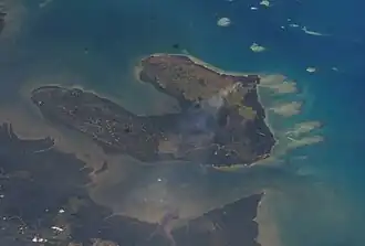
 .jpg) Top: Location of Jambongan Island within the Sulu Sea Bottom: The island seen from an aeroplane heading towards the Ninoy Aquino International Airport | |
| Geography | |
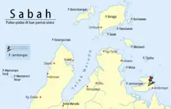
| Coordinates | 6°41′0″N 117°25′0″E / 6.68333°N 117.41667°E |
| Administration | |
| State | |
| Division | Sandakan |
| District | Beluran |
| Demographics | |
| Population | 5,000 (2019) |
Jambongan Island (Malay: Pulau Jambongan/Jembongan; Bajau-Suluk: Jambangan) is located on the northern coast of Beluran District, Sabah in Malaysia. With an area of 113 square kilometres (44 sq mi), it is considered the second largest island in Sabah,[3][4] located in Paitan Bay of the Sandakan Division.[5] Its main settlement, the Jambongan town, is located on the southeast part of the island. The highest point on the island is Buli Gantungan Hill (Malay: Bukit Buli Gantungan), at a height of 156 metres (512 ft).[1] As of 2019, the island has an estimated population of 5,000.[4]
Etymology
There are several theories on the origin of the island name. The first comes from the word Jambangan, which refers to an attractive flower, and various types of plants grow around the island.[2] When the British acquired the island, they could not pronounce the word with the correct pronunciation; they were more used to calling the island Jambongan.[6][7] Since this became the norm, the inhabitants of the island also followed the British way of pronunciation, although a few elderly still call the island by the former name.[8]
The second theory results from the daily usage by British security members stationed on the island in the past that would call the island Jambongan whenever they sent a report or made contact.[8] There is a strong link that the naming occurred throughout the British administration era, when a British governor visited the island with the aim of persuading the local Bajau people from collaborating on the Mat Salleh rebellion against the British.[8] At the time, they brought a bouquet of flowers for the village head, which subsequently resulted in the naming. With the island also rich in its lush greenery, the Jambongan name is also believed to be taken from the local word for "jambongan bunga" (a bouquet of flowers), which are directly connected to the event.[8]
History
The island was once under the thalassocracy of the Sultanate of Brunei, as were many of the areas of northern Borneo before the arrival of European powers, although the island was still uninhabited at the time.[5] Around 1704, Brunei ceded the northern part of Borneo from Kimanis northward, including the islands of Palawan, Banggi, and Balambangan, to the Sultanate of Sulu as a reward for their help during the Brunei Civil War.[9] Among the earliest Bajau-Suluk inhabitants after the Sulu conquest, the island was believed to be once guarded by supernatural beings.[10][11] Through oral history from the older island generations, the earliest inhabitants, the Suluk people, had communicated with the spirits on the island before being allowed to open up a settlement, where the communication session involved a shaman as an intermediary.[10] A port was firstly opened by the founders, and before they reached the island, this early group first stopped at Libaran and Banggi islands since the living of the group is more focused on the ocean than on the land.[10]
British acquisition
In 1877, Sultan Abdul Momin of Brunei granted to both von Overbeck and Alfred Dent of the North Borneo Chartered Company (NBCC) the territories from the Sulaman River to the Paitan River on the northeast coast, including the island of Banggi (spelt as Banguey at the time) and all other islands within three marine leagues of the coast (approximately 16 kilometres (9.9 miles) from the shoreline), as well as from Paitan to the Sibuco River.[12][13] In 1903, the Sultanate of Sulu further made a confirmation of their cession of all islands that are near to the territory of British North Borneo of the NBCC, from Banggi as far as the Sibuco Bay.[14] In 1894, Governor Charles Vandeleur Creagh established a customs station on the island, staffed by a native clerk and a policeman.[15] This angered Mat Salleh since he had already inherited the administration in the Sugut River from his father (the former Chief of Sulu in the river) and exercised power in the area from the same year.[16] His position was threatened when the NBCC introduced a poll tax and boat permits, which he considered an infringement on the rights of the local community.[16] Following the murder of two Iban Dayaks who are the agents of NBCC on the island where Mat Salleh is implicated,[17] it became one of the sites during the hunt for Mat Salleh by British forces during the Mat Salleh rebellion.[18][19]
During the Japanese occupation in World War II, the Japanese also imposed taxes on the islanders, but their authorities were seen as more cruel than the British, as they frequently threatened any local villagers found to disobey the Japanese orders, and when they refused, they would immediately be taken away and killed in a very cruel way.[20] Following the killing of a local villager during the wartime, the incident caused heavy worries among the people, and many became resistance members and chose to collaborate much closer with the British.[21][22] This resulted in a close partnership towards the Allied liberation of Borneo, with the British being perceived by local villagers as a "saviour entity from the cruelty of Japanese administration at the time".[23] Following the defeat of Japan, the British return to administer the island until the late 1950s. Throughout the colonial era, village head became the intermediaries between the colonial administration authorities and local villagers in administration matters and local economic issues.[23]
Present history
Since the 1960s, several schools have been established to improve the islanders literacy, both primary and Islamic religious schools.[24] The government also established health clinics; those with more severe health issues will usually be admitted to the main hospitals in Beluran and Sandakan, such as the Beluran Hospital and Duchess of Kent Hospital.[24] A Royal Malaysia Police station and Malaysian Army camp are maintained for security as part of the Eastern Sabah Security Command (ESSCOM) and Eastern Sabah Security Zone (ESSZONE).[24][25][26][27] Health facilities camps are also maintained by the Royal Malaysian Navy yearly, providing free health check-ups/screenings for the islanders for the prevention and early detection of infectious diseases among the people.[28] Local fishermen on the island receiving annual government aid such as fuel subsidy and living allowance through the Malaysia Fisheries Development Authority (MFDA) of Sabah.[29]
Geography
The island is located within the Coral Triangle Scientific Area.[30] It is part of the Bengkoka lowlands, formed of sandstones and shales of the Bongaya formation with alluvial deposits along the coast; its terrain is generally flat or undulating.[31] Between 50,000 and 9,000 years BP, when the sea level was 36 m below its present level, the island was part of the land region called Greater Sabah, together with Balambangan, Banggi, and Malawali islands.[32] In the present time, among the northern islands of Mandidarah and Malawali, Jambongan has the widest mangrove area.[33] As the second largest island in Sabah, it hosts a variety of biodiversity.[3][4] The island is also known for its diverse marine life, including various species of fungi and sea cucumbers;[34] these include Aniptodera sp., Sphaerulina orae-maris, and Rhizophila marina.[35] Dugongs have been sighted around the island, although their sightings are rare, together with the Irrawaddy dolphin and the Indo-Pacific humpback dolphin.[36][37] Due to an El Niño-related fire event around 30 years ago in the 1980s that destroyed much of the natural forest at the Jambongan Forest Reserve,[38] much of the island landscape has been covered with fern and Imperata cylindrica grassland.[39] In 2011, part of the affected area was planted with fast-growing trees to re-establish forest cover.[39]
Climate
It experiences a hot and humid equatorial climate with temperatures generally ranging from 26 °C (79 °F) to 32 °C (90 °F) year-round, with rain that can be expected throughout the year. The island's location within the Sulu Sea makes it susceptible to thunderstorms and strong winds while at the same time its lush greenery offering cover from prevailing winds.[40]
Conservation sites
The island is one of the mangrove forest reserve areas in Sabah,[41] with the sea surrounding the island identified as among the habitat areas for dugongs.[42] The Jambongan Forest Reserve constituted a Class 1 Protection Forest,[43] conserved for protecting the island forests, soil, watersheds, and other essential environmental factors with any timber harvesting is not permitted within the area.[44][45][46] The unscrupulous attempt at expansion of oil palm mills has been met with protest since its presence on the island damaged the island's water source and its ecosystems.[30] In 2011, the Kadazan-Dusun indigenous tagal (conservation system) was introduced to the island sea cucumber sites to conserve it following the excessive harvest that damaged its habitat due to trawler activities as well as pollution.[47][48]
Demographics
The island is inhabited by various ethnicities, with most being from the Bajau-Ubian and Suluk peoples.[49][50] The Suluks are among the first to establish settlement on Jambongan and are responsible for the island opening.[10] There were also the West Coast Bajau who established their presence on the island.[51]
Ethnic groups and languages
The main ethnicities on the island are Bajau of Ubian and Suluk,[49][52] followed by Bugis and Bruneian Malays.[4] The main spoken mother tongue is Tausug (Suluk), Bajau/Ubian, Buginese and Brunei Malay, with the official Malay language understood by most.[53][54]
Religion
Since the most ethnic groups inhabiting the island primarily come from the majority Muslim groups, the dominant religion practised is Sunni Islam, with the majority of the inhabitants adhering to it, although among the Muslim communities there were also strong cultural and traditional beliefs deeply rooted in their society, where they incorporate elements of both Islam and their ancestral practices.[11][19][50] An Islamic religious school (madrasa) established its presence on the island in 2016, providing free Islamic education for the islanders.[24]
Economy
Fishery and farming became the main source for the islanders income.[55][56] Deer hunting is also practised by the locals.[57] Trade activities flourished throughout the British administration, with barter practised among the locals.[58] During the British North Borneo era, coal was discovered on the island,[59] which differs from other coals in British Borneo, where it has some of the characteristics of anthracite.[60] The island also became the producer of copra in the 1960s, where much of the produce was sold to the towns of Sandakan and Kudat.[61] Under the present Sabah and Malaysian governance, oil palm plantation was introduced on the island in 2004,[62] with the first factory being Genting Plantations, followed by Sime Darby and TH Plantations.[63] Sea cucumber products such as gamat are harvested around the island.[64] Most of the seaweed related products are sold to the state capital city of Kota Kinabalu and popular among local Malays and Japanese and Korean tourists.[64]
Transportation
The primary mode of transportation to the island is by boat from both the Pitas and Beluran districts, which takes around 1.5 hours.[65] The island offers several anchoring options, especially on the north, while the south and east need precaution for reef. The bays on the west, meanwhile, are very shallow.[40]
See also
References
- ^ a b US Government Publishing Office 2002, p. 283.
- ^ a b Shin Lee Jin 2024, p. 264.
- ^ a b Roundtable on Sustainable Palm Oil 2014, p. 5.
- ^ a b c d Zainudin, Aniza (28 June 2019). "Keistimewaan 'wajah senyuman'" [The special feature of 'smiley face']. Harian Metro (in Malay). Archived from the original on 6 August 2025. Retrieved 6 August 2025.
- ^ a b Cherry 1923, p. 73.
- ^ Lucas 1906, p. 258.
- ^ Shin Lee Jin 2024, p. 264–265.
- ^ a b c d Shin Lee Jin 2024, p. 265.
- ^ Wright 1988, pp. 34–35.
- ^ a b c d Shin Lee Jin 2024, p. 266.
- ^ a b Jazlan, Juzaimie (18 May 2016). "Pulau Jambongan banyak pantang-larang" [Jambongan Island has many taboos]. Berita Harian (in Malay). Archived from the original on 6 August 2025. Retrieved 6 August 2025.
- ^ "Grant by Sultan of Brunei of Territories from the Sulaman River to the River Paitan dated 29th December 1877" (PDF). State Attorney-General's Chamber (British North Borneo Treaties ed.). 29 December 1877. Archived (PDF) from the original on 30 July 2025. Retrieved 30 July 2025.
- ^ "Grant by Sultan of Brunei of Territories from Paitan to Sibuco River dated 29th December 1877" (PDF). State Attorney-General's Chamber (British North Borneo Treaties ed.). 29 December 1877. Archived (PDF) from the original on 30 July 2025. Retrieved 30 July 2025.
- ^ "Confirmation by Sultan of Sulu of Cession of certain Islands dated 22nd April 1903" (PDF). State Attorney-General's Chamber (British North Borneo Treaties ed.). 22 April 1903. Archived (PDF) from the original on 29 July 2025. Retrieved 29 July 2025.
- ^ Black 1970, p. 301.
- ^ a b Mohamed Hassan 2017, p. 12.
- ^ Mohd Radzi, Basrah Bee & Abd Rahim 2008, p. 80.
- ^ Rutter 1922, p. 190.
- ^ a b Ooi 2004, p. 862.
- ^ Shin Lee Jin 2024, p. 266–267.
- ^ Shin Lee Jin 2024, p. 267–268.
- ^ Journal of the Malaysian Branch of the Royal Asiatic Society 2007, p. 30.
- ^ a b Shin Lee Jin 2024, p. 268.
- ^ a b c d Shin Lee Jin 2024, p. 274.
- ^ "Two MMEA vessels for S'kan, Tawau security". Daily Express. 11 September 2015. Archived from the original on 7 August 2025. Retrieved 7 August 2025.
- ^ "Lahad Datu to have army camp". The Borneo Post. 10 February 2023. Archived from the original on 7 August 2025. Retrieved 7 August 2025.
- ^ "Maritime Security In Sabah East Coast Beefed-Up With Comprehensive Approach – Deputy Minister". Bernama. 12 March 2025. Archived from the original on 7 August 2025. Retrieved 7 August 2025.
- ^ Shin Lee Jin 2024, p. 274–275.
- ^ Mu, Paul (11 February 2022). "77 fishermen in Pulau Jambongan to receive government aid for oil and living allowance". New Straits Times. Archived from the original on 6 August 2025. Retrieved 6 August 2025.
- ^ a b "Sepa is against mill in Jambongan". Daily Express. 10 July 2012. Archived from the original on 10 August 2025. Retrieved 10 August 2025.
- ^ Thomas, Lo & Hepburn 1976, p. 6.
- ^ Muda 2016, p. 32.
- ^ (Hazirah Awaluddin et al. 2015, p. 44)
- ^ S. S., Shukhairi; N., Mazlan; V. K., Subbiah; N. N., Abd Rahman; M. N. A., Nazahuddin; A. S., Shawel; A. D., Tuzan; S. R., Muhammad Shaleh; N., Mohd Faudzi; R., Shapawi; M. D., Shah; T. Y., Thung (2024). "Evaluation of Microplastics Ingested by Sea Cucumber Holothuria Scabra from Pulau Jambongan, Sabah". Bulletin of Environmental Contamination and Toxicology. 114 (1) 2. doi:10.1007/s00128-024-03980-0. PMID 39627569.
- ^ (Hazirah Awaluddin et al. 2015, p. 43)
- ^ Rajamani 2013, p. 173.
- ^ Sabah Biodiversity Centre 2010, p. 19.
- ^ "Sabah TLAS Audit Report [Sabah Legality Standard Principles 1 – 4]" (PDF). Global Forestry Services. 2024. p. 2. Archived (PDF) from the original on 11 August 2025. Retrieved 11 August 2025.
El Nino drought-induced fires during the 1980s destroyed much of the natural forest of the Jambongan Forest Reserve.
- ^ a b Food and Agriculture Organization of the United Nations 2025, p. 149.
- ^ a b Woods, Sue; Woods, John (2014). "M.V. SOLITA'S PASSAGE NOTES [SABAH, BORNEO, MALAYSIA]" (PDF). Noonsite. pp. 9 & 47. Archived (PDF) from the original on 13 August 2025. Retrieved 14 August 2025.
- ^ (Tangah et al. 2020, p. 1)
- ^ Rajamani & Marsh 2010, p. 22.
- ^ "[STATE OF SABAH] FORESTS (CONSTITUTION OF FOREST RESERVES AND AMENDMENT) ENACTMENT 1984 (No. 4 of 1984)" (PDF). State Attorney-General's Chamber (Sabah Laws ed.). 2019. pp. 14 & 18. Archived (PDF) from the original on 13 August 2025. Retrieved 13 August 2025.
- ^ "Forest Reserve Classes". Sabah Forestry Department. Archived from the original on 13 August 2025. Retrieved 13 August 2025.
- ^ Kasmir, Winnie (18 November 2019). "Stripping mangrove barks: Filipino duo caught". Daily Express. Archived from the original on 13 August 2025. Retrieved 13 August 2025.
- ^ Chong, Rebecca (9 September 2021). "Forestry Dept nabs teen migrant for stealing tangar tree bark from Sabah forest reserve". The Vibes. Archived from the original on 13 August 2025. Retrieved 13 August 2025.
- ^ "Sabah introduces 'tagal' system to conserve sea cucumber". Bernama. 27 May 2011. Archived from the original on 11 August 2025. Retrieved 11 August 2025 – via The Borneo Post.
- ^ "Six Vietnamese fishermen caught collecting sea cucumbers illegally near Pulau Jambongan". Bernama. 15 September 2019. Archived from the original on 11 August 2025. Retrieved 11 August 2025 – via The Borneo Post.
- ^ a b Shin Lee Jin 2024, p. 263–266.
- ^ a b Hj. Mahali 2018, p. 85.
- ^ Department of Linguistics, Research School of Pacific Studies, Australian National University 1983, p. 101.
- ^ Wilson 1961, p. 19.
- ^ Ministry of Education, Malaysia 2017, p. 1–6.
- ^ Mohamed Zuki & Wan Mohamad 2017, p. 28–29.
- ^ Shin Lee Jin 2024, p. 270–272.
- ^ Colony of North Borneo annual report 1958, p. 16.
- ^ Wong et al. 2012, p. 39.
- ^ Shin Lee Jin 2024, p. 272–273.
- ^ Times Periodicals, -[1982?] 1906, p. 79.
- ^ H.M. Stationery Office 1951, p. 73.
- ^ Shin Lee Jin 2024, p. 272.
- ^ Roundtable on Sustainable Palm Oil 2014, p. 6–8.
- ^ Shin Lee Jin 2024, p. 273.
- ^ a b Jun 2014, p. 7–9.
- ^ "Projek Komuniti Pulau Jambongan" [Jambongan Island Community Project]. PMP Subang (in Malay). Archived from the original on 13 August 2025. Retrieved 13 August 2025.
Bibliography
- Lucas, Sir Charles Prestwood (1906). A Historical Geography of the British Colonies: The Mediterranean and Eastern colonies (2nd ed., 1906). Clarendon Press.
- The Straits Times Annual. Times Periodicals, -[1982?]. 1906.
- Rutter, Owen (1 January 1922). British North Borneo : an account of its history, resources, and native tribes. Dalcassian Publishing Company.
- Cherry, William Thomas (1923). Geography of British Malaya and the Malay Archipelago: Together with Brief Historical Outlines of the Principal Areas Under British Protection. Methodist Publishing House.
- Overseas Geology and Mineral Resources. H.M. Stationery Office. 1951.
- "North Borneo 1958" (PDF). Her Majesty's Stationery Office: 1–248. 1959.
- Wilson, R. A. M. (1961). The Geology and Mineral Resources of the Banggi Island and Sugut River Area North Borneo. US Government Printing Office.
- Black, Ian Donald (1970). NATIVE ADMINISTRATION BY THE BRITISH NORTH BORNEO CHARTERED COMPANY, 1878 - 1915. Doctor of Philosophy (Thesis). pp. 2–486 – via Australian National University.
- Thomas, P; Lo, F K C; Hepburn, A J (1976). "The land capability classification of Sabah – Volume 2 – The Sandakan Residency". Land Resources Division, Ministry of Overseas Development Tolworth Tower, Surbiton. 2 (Land Resource Study 25 ed.). Surrey, England. Archived from the original on 11 August 2025 – via Wageningen University & Research, Netherlands.
- Wright, Leigh R. (1 July 1988). The Origins of British Borneo. Hong Kong University Press. ISBN 978-962-209-213-6.
- Languages of Sabah: A Survey Report. 1983-1984. Department of Linguistics, Research School of Pacific Studies, Australian National University. 1983. ISBN 978-0-85883-284-8.
- "Sailing Directions (Enroute) - Borneo, Jawa, Sulawesi and Nusa Tenggara [Sector 10. Borneo—Northeast Coast]" (PDF). United States Navy Publication. 2002. Archived (PDF) from the original on 27 July 2025 – via US Government Publishing Office.
- Ooi, Keat Gin (2004). Southeast Asia: A Historical Encyclopedia, from Angkor Wat to East Timor. ABC-CLIO. ISBN 978-1-57607-770-2.
- Journal of the Malaysian Branch of the Royal Asiatic Society. The Branch. 2007.
- Mohd Radzi, Mohd Shaukhi; Basrah Bee, Baszley Bee; Abd Rahim, Md Saffie (2008). "PERJUANGAN PADUKA MAT SALLEH MENENTANG PENJAJAH: PERJALANAN SEJARAH PENENTANGAN DAN INTERPRETASI DARI SUDUT PANDANGAN ISLAM" [Paduka Mat Salleh's Struggle Against Colonial: A Historical Struggle and Interpretation from Islamic Point of View]. Borneo Research Journal (in Malay). 2: 77–96. eISSN 2600-8645. Archived from the original on 30 July 2025 – via Universiti Malaya.
- "Sabah Biodiversity Strategy 2012–2022" (PDF). Sabah Biodiversity Centre. 2010. pp. 1–202. Archived (PDF) from the original on 10 August 2025. Retrieved 10 August 2025.
- Rajamani, L.; Marsh, H. (2010). "Using parallel regional- and local-scale initiatives to inform conservation management of rare wildlife: a case study of the dugong Dugong dugon in Sabah, Malaysia" (PDF). Endangered Species Research. 13: 17–23. doi:10.3354/esr00310. Archived (PDF) from the original on 10 August 2025 – via Inter-Research Science Publisher.
- Wong, Anna; Huaimei, Yong; Wong, Christopher; Abd. Shukor, Jumrafiah (2012). "A study on hunting activity of Sambar deer and Bearded pig in Paitan Forest Reserve, Pitas, Sabah, Malaysia". Journal of Tropical Biology and Conservation. 9 (1): 35–47. Archived from the original on 10 August 2025 – via Universiti Malaysia Sabah Journal Management System.
- Rajamani, Leela (2013). "Using community knowledge in data-deficient regions: Conserving the Vulnerable dugong Dugong dugon in the Sulu Sea, Malaysia". Fauna & Flora International, Oryx. 47 (2): 173–176. doi:10.1017/S0030605312000154. Archived from the original on 9 August 2025 – via ResearchGate.
- "RSPO New Planting Procedure Assessment Report for Proposed Oil Palm Plantation on 496.56 Ha at Jambongan Island, Beluran District, Sabah" (PDF). TÜV. 25 August 2014. Archived (PDF) from the original on 6 August 2025 – via Roundtable on Sustainable Palm Oil.
- Jun, Akamine (2014). "Toward Inclusive Dialogue for Sustainable Sea Cucumber Conservation in Malaysia" (PDF). Institute for the Study of Global Issues Hitotsubashi University: 1–17. Archived (PDF) from the original on 10 August 2025 – via Sabah Biodiversity Integrated Information.
- Hazirah Awaluddin, Hanna; Mohamad Nor, Norlailatul Asikin; Mohamed Nor, Hanzalah; Sarah Sharuddin, Siti; Pang, Ka-Lai; Mohamad-Fauzi, Nuradilla; Rizman-Idid, Mohammed; Aisyah Alias, Siti (2015). "BIODIVERSITY OF MARINE LIGNICOLOUS FUNGI FROM MANGROVES OF SULU SEA". Malaysian Journal of Science. 34 (1): 43–57. doi:10.22452/mjs.vol34no1.5. Archived from the original on 10 August 2025 – via Faculty of Science, University of Malaya E-Journal.
- Muda, Joanes (2016). "Geological indicators of sea-level changes at northern Sabah, Malaysia: Tools for instilling public awareness on global climate changes" (PDF). Bulletin of the Geological Society of Malaysia. 62: 31–35. doi:10.7186/bgsm62201605. Archived (PDF) from the original on 11 August 2025 – via SciSpace.
- Mohamed Hassan, Noraini (2017). "PERJUANGAN PEMIMPIN TEMPATAN MENENTANG BRITISH" [LOCAL LEADERS' STRUGGLE AGAINST THE BRITISH] (PDF). Doctor of Philosophy (in Malay): 1–17. Archived (PDF) from the original on 30 July 2025 – via University Malaya Research Repository.
- Mohamed Zuki, Khairul Nizam (2017). "Penerimaan Bahasa Melayu Sebagai Bahasa Kedua Dalam Kalangan Murid Berbangsa Bajau" [Acceptance of Malay as a Second Language Among Bajau Students] (PDF). International Journal of Humanities and Social Science Invention (in Malay). 6 (10): 1–11. ISSN 2319-7722. Archived (PDF) from the original on 13 August 2025.
- Mohamed Zuki, Khairul Nizam; Wan Mohamad, Wan Muna Ruzanna (2017). "SIKAP DAN MOTIVASI MURID BAJAU DALAM MEMPELAJARI BAHASA MELAYU SEBAGAI BAHASA KEDUA" [Bajau Students Attitude and Motivation in Studying Malay Language as a Second Language] (PDF). Malay Language Education Journal – MyLEJ (in Malay). 7 (1): 24–33. ISSN 2180-4842 – via UKM Journal Article Repository.
- Hj. Mahali, Saidatul Nornis (2018). "Cerakinan Bahasa Ubian Mantanani: Satu Rungkasan [sic] Awal" [The Description of Ubian Language: A Preliminary Discussion] (PDF). International Journal of the Malay World and Civilisation (in Malay). 6 (2): 83–98. doi:10.17576/jatma-2018-0602-07. Archived from the original (PDF) on 22 March 2020. Retrieved 6 August 2025 – via UKM Journal Article Repository.
- Tangah, Joseph; Y.C. Chung, Arthur; Baba, Shigeyuki; Tuck Chan, Hung; Kezuka, Mio (2020). Rehabilitation of Mangroves in Sabah [The SFD-ISME Collaboration (2014–2019)] (PDF). Sabah Forestry Department, International Society for Mangrove Ecosystems of Ryukyu University, and Tokio Marine & Nichido Fire Insurance Co., Ltd. pp. 1–70. ISBN 978-4-906584-20-8. Archived (PDF) from the original on 11 August 2025 – via ISME/GLOMIS Electronic Journal.
- Shin Lee Jin, Risna Nirwana (2024). "PERKEMBANGAN PULAU JAMBONGAN PASCAMERDEKA: 1963-2013" [Development of Jambongan Island Post-Independence: 1963-2013]. Jurnal Borneo Arkhailogia (Heritage, Archaeology & History) (in Malay). 9 (1): 261–280. eISSN 2600-8726. Archived from the original on 27 July 2025 – via Universiti Malaysia Sabah Journal Management System.
- Food and Agriculture Organization of the United Nations (12 May 2025). Innovative practices in the sustainable management of fast-growing trees: Lessons learned from poplars and willows and other experiences with fast-growing trees around the world. Food and Agriculture Organization of the United Nations. ISBN 978-92-5-139579-0.
External links
![]() Media related to Jambongan Island at Wikimedia Commons
Media related to Jambongan Island at Wikimedia Commons
Capital: Kota Kinabalu | |||||||||||
| Topics |
| ||||||||||
| Society |
| ||||||||||
| Administrative divisions |
| ||||||||||
| |||||||||||