Iru hillfort
The Iru hillfort (Estonian: Iru linnamägi or Iru Linnapära) was a major hillfort in Ancient Estonia, located near the northern coast, on the bank of Pirita river. First established in the Bronze Age, the hillfort was at the height of its prosperity during the Viking Age, before starting to decline in 10th century, coinciding with settlement growing at the location of Tallinn Old Town. Iru is commonly described as the predecessor of the modern Estonian capital Tallinn, and today lies within Tallinn's city limits.
Description
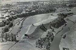
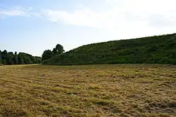
The Iru hillfort is located on the bank of the Pirita River, 8.5 km (5.3 mi) from the Tallinn Old Town,[1] within the municipal borders of the city of Tallinn.[2] It was a good defensive position, on a high and steep hill within an U-shaped bend of the Pirita river, about 4–5 km (2.5–3.1 mi) inland from the river mouth at the Tallinn Bay.[1] The hillfort has an elongated shape, with a length of 212.5 m (697 ft) and a width varying between 16–52 m (52–171 ft). There are ramparts on both ends, and also a central rampart that divides the hillfort into a smaller northern plateau with an area of 1,100 m2 (12,000 sq ft), and a larger southern plateau with an area of 4,000 m2 (43,000 sq ft). The eastern side is 9–11 m (30–36 ft) high from the foot of the hill, while the western side has a height of 10–12 m (33–39 ft) from the foot of the hill at northern plateau, and 18 m (59 ft) at southern plateau dropping directly to the river.[3]
History
Ancient Estonia
Human settlement on the Iru hill can be traced back to Corded Ware culture, during the 3rd millennium BC.[4] The hillfort was first established during the Bronze Age,[5] roughly between 800 BC and 500 BC.[6] Iru re-emerged around 5th–6th centuries, with its prosperity peaking during the Viking Age. There is no consensus among archaeologists about the exact nature of the hillfort during this period. Valter Lang suggested concentration of population into an agrarian settlement, while Marika Mägi alternatively proposed hillfort functioning primarily as a central market place, with permanent settlement being limited only to local magnate’s farm, or even just limited guard presence.[7] Iru’s location on the northern coast of Estonia placed it on a trade route towards Russia and other areas further east and south.[5] Iru started losing its prominence around the 10th century, although coin discoveries and the nature of major stone walls and a tower suggest continued limited use during the 11th and 12th centuries.[8] Around the same period a settlement was established at the location of Tallinn Old Town, with hillfort built on Toompea.[9] Nowadays the Iru hillfort is frequently described as the predecessor of Tallinn.[1]
Discovery and modern era
The Iru hillfort was discovered in early 20th century, when a story about Iru hill in the Estonian national epic Kalevipoeg caught attention of Baltic German teacher Artur Spreckelsen, who suggested that the site may have been an ancient hillfort. In 1922, a newspaper article and lecture made Spreckelsen's idea publicly known.[10] The first excavations on the hillfort started in 1936. In 1930s, excavations were led by Artur Vassar and partially also by Richard Indreko. During 1952–1958 major excavations took place under Vassar's leadership. Valter Lang excavated the central wall during 1984–1986, and in 1994 he published the results of the different excavations that had taken place on the hillfort.[11] Nowadays the hillfort is used for walks and other recreational activities.[12]
References
- ^ a b c Mägi 2015, p. 53
- ^ Kurisoo, Lillak, Rõigas, and Tint 2023, p. 201
- ^ Lang 1996, p. 34
- ^ Lang 1996, p. 37
- ^ a b Mägi 2015, p. 47
- ^ Lang 1996, p. 51
- ^ Mägi 2015, p. 54
- ^ Mägi 2007, p. 24
- ^ Mägi 2007, p. 34
- ^ Kurisoo, Lillak, Rõigas, and Tint 2023, p. 200
- ^ Mägi 2007, p. 23
- ^ Kurisoo, Lillak, Rõigas, and Tint 2023, p. 204
Bibliography
- Kurisoo, Tuuli; Lillak, Anu; Rõigas, Andres; Tint, Küllike (2023). "The role of communities in preserving, using and remembering heritage: archaeological monuments and dark heritage sites in Estonia". International Journal of Heritage Studies. 30 (2). Taylor & Francis: 195–209. doi:10.1080/13527258.2023.2284733.
- Lang, Valter (1996). Muistne Rävala: Muistised, kronoloogia ja maaviljelusliku asustuse kujunemine Loode-Eestis, eriti Pirita jõe alamjooksu piirkonnas [Prehistoric Rävala: antiquities, chronology and the establishment of farming settlement in North-West Estonia, with special reference to the area on the lower reaches of the Pirita River] (in Estonian). Estonian Academy of Sciences. ISBN 9985501462.
- Mägi, Marika (2007). "Iru linnusest Püha Birgitta kloostrini. Merenduslik kultuurmaastik Pirita jõe alamjooksul" [From the Hill-Fort of Iru to the Convent of St. Birgitta. Maritime Cultural Landscape on the Lower Reaches of the Pirita River] (PDF). Studies on Art and Architecture (in Estonian). 16 (4). Estonian Society of Art Historians. ISSN 1406-2860.
- Mägi, Marika (2015). "Bound for the Eastern Baltic: Trade and Centres ad 800—1200". In Barret, James H.; Gibbon, Sarah Jane (eds.). Maritime Societies of the Viking and Medieval World. Maney Publishing. ISBN 9781909662797.