Imielin (housing estate)
Imielin | |
|---|---|
 The multifamily housing at Indiry Gandhi Street in 2019. | |
| Coordinates: 52°08′52″N 21°02′32″E / 52.147793°N 21.042284°E | |
| Country | |
| Voivodeship | Masovian |
| City and county | Warsaw |
| District | Ursynów |
| City Information System area | Ursynów-Centrum |
| Establishment | 1981 |
| Time zone | UTC+1 (CET) |
| • Summer (DST) | UTC+2 (CEST) |
| Area code | +48 22 |
Imielin is a housing estate in the Ursynów district of Warsaw, Poland, within the City Information System area of Ursynów-Centrum. Its a high-rise multifamily residential area. It includes the Imielin station of the Warsaw Metro rapit transit system. The area was developed between 1976 and 1981.
History

The area was incorporated into Warsaw on 14 May 1951.[1]
Between 1976 and 1981, the housing esatate of Imielin, was developed with high-rise apartment buildings. They were placed between Ciszewskiego Street, Komisji Edukacji Narodowej Avenue, Płaskowickiej Street, and Pileckiego Street.[2][3] It was named after the historic neighbourhood of Imielin, located to the east, and dating to at least 15th century.[4]
On 7 April 1995, the Imielin station of the M1 line of the Warsaw Metro rapid transit underground syststem, was opened at the intersection of Komisji Edukacji Narodowej Avenue and Indiry Gandhi Street.[5][6]
Between 1995 and 2001, the Thomas the Apostle Church of the Catholic denomination, was constructed at 12 Dereniowa Street.[7]
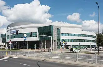
In 2007, the Arena Ursynów indoor sports arena was opened at 122 Pileckiego Street.[8][9]
In 2008, Ursynów Town Hall, the seat of district government, was opened at 61 Komisji Edukacji Narodowej Avenue.[8][10]
Overview
Imielin is a housing estate located between Ciszewskiego Street, Komisji Edukacji Narodowej Avenue, Płaskowickiej Street, and Pileckiego Street. It consists of high-rise apartment buildings.[2] The intersection of Komisji Edukacji Narodowej Avenue and Indiry Gandhi Street features the Imielin station of the M1 line of the Warsaw Metro rapid transit underground syststem, at the intersection of Komisji Edukacji Narodowej Avenue and Indiry Gandhi Street. Additionally, the neighbourhood includes the Thomas the Apostle Church of the Catholic denomination at 12 Dereniowa Street, and the Arena Ursynów indoor sports arena was opened at 122 Pileckiego Street.[7][9] There are also locsted the Ursynów Town Hall, the seat of district government, at 61 Komisji Edukacji Narodowej Avenue, and the headquarters of the National Clearing House, an institution of the banking sector in Poland.[10][11]
References
- ^ "Rozporządzenie Rady Ministrów z dnia 5 maja 1951 r. w sprawie zmiany granic miasta stołecznego Warszawy". isap.sejm.gov.pl (in Polish).
- ^ a b Barbara Petrozolin-Skowrońska (editor): Encyklopedia Warszawy, vol 1. Warsaw: Wydawnictwo Naukowe PWN, 1994, pp. 920–921. ISBN 9788301088361. (in Polish)
- ^ "Wielki projekt Ursynowa Płd. Prospekt Spółdzielni Ursynów. Koniec lat siedemdziesiątych". ursynow.org.pl (in Polish). 18 December 2017.
- ^ Barbara Petrozolin-Skowrońska (editor): Encyklopedia Warszawy, vol 1. Warsaw: Wydawnictwo Naukowe PWN, 1994, p. 275. ISBN 9788301088361. (in Polish)
- ^ "Dane techniczne i eksploatacyjne istniejącego odcinka metra". metro.waw.pl (in Polish). Archived from the original on 2016-03-05. Retrieved 2024-03-10.
- ^ Wszystko zaczęło się na Wilanowskiej – 20 lat metra. In: iZTM, no. 4 (86). April 2015. Warsaw: Zarząd Transportu Miejskiego. pp. 9–10. (in Polish)
- ^ a b "Warszawa. Św. Tomasza Apostoła". archwwa.pl (in Polish).
- ^ a b Maciej Petruczenko (11 January 2017). "Ważne daty w historii blokowiska Ursynów". passa.waw.pl (in Polish).
- ^ a b "Hala sportowa Arena Ursynów – Pileckiego 122". sport.um.warszawa.pl (in Polish).
- ^ a b "Dane Urzędu". ursynow.um.warszawa.pl (in Polish).
- ^ "Krajowa Izba Rozliczeniowa". kir.pl (in Polish).
| Neighbourhoods |  | |
|---|---|---|
| Parks |
| |
| Education and science |
| |
| Sports |
| |
| Religion |
| |
| Culture |
| |
| Other buildings |
| |
| Transport | ||
| Roads | ||
| Geography |
| |