Hurricane Camille
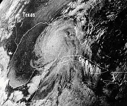 Camille near peak intensity in the Gulf of Mexico on August 16 | |
| Meteorological history | |
|---|---|
| Formed | August 14, 1969 |
| Dissipated | August 22, 1969 |
| Category 5 major hurricane | |
| 1-minute sustained (SSHWS/NWS) | |
| Highest winds | 175 mph (280 km/h) |
| Lowest pressure | 900 mbar (hPa); 26.58 inHg |
| Overall effects | |
| Fatalities | 259 total |
| Damage | $1.42 billion (1969 USD) |
| Areas affected | Cuba, Yucatán Peninsula, Southern United States, Midwestern United States, East Coast of the United States |
| IBTrACS | |
Part of the 1969 Atlantic hurricane season | |
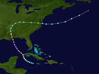
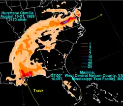
Hurricane Camille was an extremely powerful and catastrophic Atlantic hurricane which became the second most intense on record to strike the continental United States (behind the 1935 Labor Day hurricane) and is one of four Category 5 hurricanes to make landfall in the continental United States. The third and most intense storm of the 1969 Atlantic hurricane season, Camille originated as a tropical depression on August 14, south of Cuba, from a long-tracked tropical wave. Located in a favorable environment for strengthening, the storm quickly intensified into a Category 2 hurricane before striking the western part of Cuba on August 15. Emerging into the Gulf of Mexico, Camille underwent another period of rapid intensification and became a Category 5 hurricane the next day as it moved northward towards Louisiana and Mississippi. Despite weakening slightly on August 17, the hurricane quickly re-intensified back into a Category 5 hurricane before it made landfall a half hour before midnight in Bay St. Louis, Mississippi. At peak intensity, the hurricane had peak 1-minute sustained winds of 175 miles per hour (282 km/h) and a minimum pressure of 900 mbar (26.58 inHg), the second-lowest pressure recorded for a U.S. landfall behind the 1935 Labor Day hurricane.
Camille weakened quickly as it pushed inland, falling below hurricane strength north of Jackson, Mississippi and weakening further to a tropical depression over Tennessee. Camille tracked through the Ohio Valley as a tropical depression, bringing heavy rainfall and catastrophic flooding before moving back offshore on the coast of Virginia. After emerging offshore, Camille restrengthened to a strong tropical storm before becoming extratropical on August 22. Camille was absorbed by a frontal storm over the North Atlantic later that day.
In Cuba, Camille brought high winds and caused major river flooding, killing at least 5 people. In the United States, Camille caused tremendous damage and produced a peak official storm surge of 24 feet (7.3 m), flattening nearly everything along the Mississippi coast and portions of southeast Louisiana. Camille's winds caused severe damage along its path in southwest Mississippi, damaging buildings and devastating the region's agriculture. As a tropical depression, Camille caused additional flooding and deaths while crossing the Appalachian Mountains of Virginia. In the U.S., Camille killed at least 259 people[1][2] and caused at least $1.42 billion in damages (equivalent to $12.2 billion in 2024), tying it with Hurricane Betsy as the costliest hurricane in U.S. history up to that point.[3]
Meteorological history
Tropical storm (39–73 mph, 63–118 km/h)
Category 1 (74–95 mph, 119–153 km/h)
Category 2 (96–110 mph, 154–177 km/h)
Category 3 (111–129 mph, 178–208 km/h)
Category 4 (130–156 mph, 209–251 km/h)
Category 5 (≥157 mph, ≥252 km/h)
Unknown
Hurricane Camille originated from a tropical wave that moved off the western coast of Africa on August 5, 1969. It tracked quickly westward along the 15th parallel north;[4] several days later, a tropical disturbance became clearly identifiable on satellite imagery on August 9. By that time, the thunderstorm activity in the disturbance concentrated into a circular area of convection. On the next day, the storm moved through the Lesser Antilles, although there was no evidence of a closed circulation. On August 13, the wave passed near or over the southern coast of Jamaica as its convection spread northeastward through the Bahamas. Subsequently, it began a slower motion to the northwest. It is believed that the tropical wave organized into a tropical depression shortly thereafter, early on August 14, and it became a tropical storm a few hours later. On the morning of August 14, the Hurricane Hunters flew to investigate for a closed circulation near the Bahamas and near the Cayman Islands.[5] The crew observed a developing center in the western Caribbean, and winds had reached tropical storm status. By then, the storm had strengthened into a strong tropical storm with winds of 60 mph (97 km/h), about 50 miles (80 km) west-northwest of Grand Cayman.[5][6]
.jpg)
Upon first being classified as a tropical storm, Camille was located in an area favorable for further strengthening, although initially it slowly intensified. It was located within an area of very light wind shear and an overall warm environment. Additionally, the storm developed strong low-level inflow from the deep southern Caribbean, which continuously brought moisture into the storm.[5] Throughout its duration, it was a small tropical cyclone, although with a radius of gale-force winds spreading 100 miles (160 km) to the north, the storm's thunderstorm area quickly spread over Cuba. As the storm approached the western coast of Cuba, it began rapid deepening, reaching hurricane status early on August 15 and attaining winds of 110 mph (180 km/h) less than 12 hours later. Prior to landfall, its eye was tracked by radar from Havana; it is estimated the hurricane moved ashore between Cape San Antonio and Guane late on August 15 as a strong Category 2 hurricane. Camille was a small hurricane as it crossed western Cuba, and its winds decreased slightly to 105 mph (169 km/h) over land before it emerged into the Gulf of Mexico.[6]
| Rank | Hurricane | Season | Pressure | |
|---|---|---|---|---|
| hPa | inHg | |||
| 1 | Wilma | 2005 | 882 | 26.05 |
| 2 | Gilbert | 1988 | 888 | 26.23 |
| 3 | "Labor Day" | 1935 | 892 | 26.34 |
| 4 | Rita | 2005 | 895 | 26.43 |
| Milton | 2024 | |||
| 6 | Allen | 1980 | 899 | 26.55 |
| 7 | 1969 | 900 | 26.58 | |
| 8 | Katrina | 2005 | 902 | 26.64 |
| 9 | Mitch | 1998 | 905 | 26.73 |
| Dean | 2007 | |||
| Source: HURDAT[7] | ||||
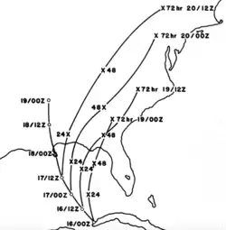
Initially, Hurricane Camille was forecast to turn northeastward toward the Florida panhandle. Instead, it continued northwestward and resumed its rapid intensification trend after leaving Cuba. Its eye contracted to a diameter of less than 8 miles (13 km), and strong rainbands developed around the entire hurricane. Due to the small eye, the Hurricane Hunters at first had difficulties in determining the strength; however a flight late on August 16 found a strong Category 5 hurricane on the Saffir–Simpson scale and recorded a very low pressure of 908 mbar (hPa; 26.82 inHg), with winds estimated at 175 mph (282 km/h).[5] At the time, it was not expected to intensify further.[6] However, a subsequent Hurricane Hunters flight early on August 17 recorded a slightly deeper central pressure of 905 mbar (hPa; 26.73 inHg), at the time the lowest pressure recorded by reconnaissance aircraft. This made Camille the most intense hurricane since the 1935 Labor Day hurricane.[8][7]
As it continued toward the Gulf Coast of the United States, Camille maintained its small eye, and forecasters continued to anticipate a turn toward Florida.[6] Late on August 17, Camille briefly weakened to a Category 4 storm due to an eyewall replacement cycle; a reconnaissance flight was forced to end its mission early due to a damaged engine.[5] Before they left the storm, the crew recorded a pressure of 919 mbar (hPa; 27.14 inHg) and estimated surface winds at 155 mph (249 km/h), while Camille was located about 100 miles (160 km) southeast of the Mississippi River Delta.[6] There were no subsequent Hurricane Hunter flights, but surface observations recorded later suggested that Camille quickly re-strengthened and regained Category 5 intensity.[8] After passing very close to southeastern Louisiana, Hurricane Camille made landfall at 11:30 CDT in Waveland, Mississippi. Maximum sustained wind speeds near the coastline were estimated to have been about 175 mph (282 km/h), with a minimum central pressure of 900 mbar (hPa; 26.58 inHg) as analyzed by surface data.[9]
The hurricane weakened as it progressed inland, and within 14 hours of moving ashore, Camille weakened to tropical storm status. About 12 hours later, it weakened to tropical depression status, by which time it began a turn to the north and northeast. On August 20, Tropical Depression Camille turned eastward through Kentucky, dropping heavy rainfall in West Virginia and Virginia. Later that day, it emerged into the Atlantic Ocean east of Norfolk, and by that afternoon, as Camille was emerging offshore it regained tropical storm status. Camille accelerated east-northeastward, attaining peak winds of 70 mph (110 km/h) as it interacted with larger Hurricane Debbie to its southeast (although the poor sampling of the region means that it is possible that the storm may have regained hurricane intensity in a location where measurements of wind speed were not taken).[5] Subsequently, Camille began to interact with a frontal storm, causing it to gradually transition into an extratropical cyclone as it entrained cooler air. On August 22, Camille was absorbed by the frontal system to the south of Atlantic Canada.[5][6]
Records
Camille produced the seventh lowest official sea level pressure ever recorded in the Atlantic basin, at 900 millibars (27 inHg).[7] This was also its landfall pressure; the only hurricane to hit the United States with a lower pressure at landfall was the Labor Day Hurricane of 1935.[8][10] The wind speed of Camille can only be approximated, as no meteorological equipment survived the extreme conditions at landfall, but a reanalysis in April 2014 estimated that Camille had maximum sustained winds of 175 mph (282 km/h).[11] Before Hurricane Katrina in 2005, Camille likely had the highest storm surge measured in the United States, at over 24 feet (7.3 m).
Preparations
Shortly after Camille formed, the National Hurricane Center advised residents on the Isle of Pines and in western Cuba to prepare for gale-force winds, heavy rains, and rising tides. The agency also recommended small boats to remain in harbor.[6] The threat of the storm prompted officials to evacuate thousands along the western coast of Cuba and on the Isle of Pines; on the island, 10,000 cattle and 6,000 turkeys were moved to safer areas.[12]
As Camille impacted Cuba, small craft were advised not to venture out too far from the coasts of Florida. On August 15, the National Hurricane Center issued a hurricane watch for a 110 miles (180 km) stretch of land in Florida, between Apalachicola and Fort Walton Beach. The next day, as these hurricane watches were upgraded to a hurricane warning, thousands of people boarded up their homes and evacuated inland. During the afternoon of August 16, the weather bureau ordered that a hurricane watch should be placed in force for the coastline from Biloxi to St Marks, Florida. Later that day, the hurricane watches were upgraded to a hurricane warning for the northwestern Florida coast, from Fort Walton to St Marks.[6]
By Saturday morning, a hurricane watch was issued for the coast from Biloxi eastward. Civil defense organizations in coastal counties went on alert. Keesler Air Force Base and the Naval Construction Battalion Center prepared for the storm. By 5 p.m. on Sunday, a hurricane warning was issued for the coast. This activated the National Guard units. Many refused to believe the reports concerning Camille's intensity that afternoon. Many people living at elevations of 20 feet (6.1 m) above sea level refused to believe they were going to be submerged. The mayor of Gulfport ordered the release of prisoners from the city jail as winds increased at 9 p.m. on Sunday evening, but none would leave.[13]
Due to the lack of real-time rainfall information, forecasters were unable to issue flood warnings in mountainous regions of Virginia. The city of Richmond had advanced warning of the floods and was able to implement its flood disaster plan.[5][14]
Impact
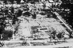
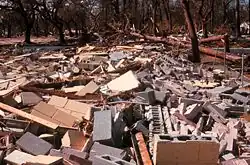
Making landfall in Waveland, Mississippi, as a Category 5 hurricane,[8] Camille caused damage and destruction across much of the Gulf Coast of the United States. Because it moved quickly through the region, Hurricane Camille dropped only moderate precipitation in most areas. Areas in and around Pass Christian, its point of landfall, reported from 7 to 10 inches (180 to 250 mm).[15] The area of total destruction in Harrison County, Mississippi was 68 square miles (180 km2).[16] The total U.S. estimated cost of damage was $1.42 billion (1969 USD).[3] This made Camille tied (with Hurricane Betsy) as the most expensive hurricane in the United States, up to that point.[17] The storm directly killed 143 people along Alabama, Mississippi, and Louisiana. An additional 153 people perished as a result of catastrophic flooding in Nelson County, Virginia and other areas nearby.
Caribbean and Offshore Gulf of Mexico
As a developing tropical storm, Camille brought rain showers to Grand Cayman, although there were no reports of damage.[6] Stations in Cuba on the outer fringes of the storm reported winds of 50 mph (80 km/h). East of where it moved ashore, the city of Guane recorded winds of 92 mph (148 km/h), although no wind reports were taken in the landfall location. The hurricane produced up to 10 inches (250 mm) near Guane, as well as on the Isle of Pines.[6] On the Isle of Pines, the storm inflicted damage to about 100 houses.[12] Throughout Pinar del Río Province, Camille caused heavy damage,[18] primarily from river flooding;[19] about 20,000 people were left homeless in the province. Strong winds downed trees and power lines, which caused power outages eastward through the capital city of Havana. Initially, the government reported no casualties from the storm.[18] Subsequent research indicated the hurricane killed five people in the country during its passage, and damage was estimated at $5 million (1969 USD).[20]
In the open Gulf of Mexico, the hurricane produced wave heights of at least 70 feet (21 m), as measured by Shell Oil Company. Along the ocean floor, the storm created mudslides which lowered the ocean floor; its combination with strong waves and winds destroyed three oil platforms, including one that at the time was the deepest oil well. Property damages to the offshore oil industry were initially estimated at $100 million (1969 USD).[21] A drilling rig recorded 10-minute sustained winds of 130 miles per hour (210 km/h) before the anemometer failed.[9]
Louisiana
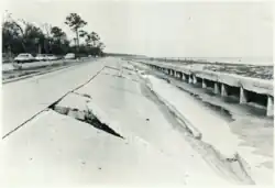
Though Camille did not make landfall in Louisiana, the storm produced category 5 conditions in the state.[22] The barometric pressure fell to 27.80 inches of mercury (941 hPa) at Garden Island. Winds reached an estimated 125 miles per hour (201 km/h) at Slidell as their pressure sank to 28.56 inches of mercury (967 hPa) on August 17. Almost total destruction was seen from Venice to Buras. The worst storm surge flooding occurred in Plaquemines Parish and lower St. Bernard Parish. Ostrica Lock measured a storm surge of 16 feet (4.9 m). Several feet of surge also occurred along the shores of Lake Pontchartrain and around Grand Isle. Water overwashed U.S. Highway 90 to a depth of 10 feet (3.0 m).[23][24][25] The highest rainfall report from the state was 5.23 inches (133 mm) from Slidell.[26] Winds in Boothville-Venice reached 107 mph before the instrument lost power, and he combination of winds and storm surge destroyed the local weather bureau office, fire station, and school.[27][28][5] The storm turned in time to avoid a direct hit to the City of New Orleans, which was devastated just four years prior by Hurricane Betsy. The worst effects in New Orleans proper were flooding from some levees. A break in the uptown side of the Industrial Canal levee caused 3 feet of flooding.[29] Strong winds caused damage to storefronts in the downtown area.[30] Wind gusts at Lakefront Airport reached 109 mph.[5]
In addition, Camille forced the Mississippi River to flow backwards for a river-distance of 125 miles (from its mouth to a point north of New Orleans). The river further backed up for an additional 120 miles (190 km), to a point north of Baton Rouge.[31] Camille caused about $322 million (1969 dollars) of damage in Louisiana.[5]
Mississippi

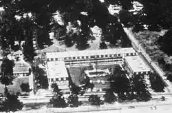
In Mississippi, Camille was significantly worse than Hurricane Betsy. Electricity went out during Camille's approach to the Mississippi coastline. United States Highway 90 flooded as a large storm surge overtopped seawalls, leaving a barge along the highway in Gulfport. Fires consumed coastal communities, with the exceptions of Bay St. Louis and Waveland. Camille destroyed the antebellum Trinity Episcopal church in Pass Christian, taking 15 lives. A school in Pass Christian was severely damaged by high winds.[32] The Dixie White House, where President Woodrow Wilson and his family once stayed, was badly damaged.[13] The highest rainfall total recorded was 10.06 inches (256 mm) at the Mississippi Test Facility.[26] Upon making landfall, Camille produced a 24 foot (7.3 m) storm surge.[33] Along Mississippi's entire shore and for some three to four blocks inland, the destruction was nearly complete. The worst-hit areas were Clermont Harbor, Lakeshore, Waveland, Bay St. Louis, Pass Christian, Long Beach, and the beachfront of Gulfport, Mississippi City, and Biloxi. One of Frank Lloyd Wright's waterfront houses for W. L. Fuller, in Pass Christian, was completely destroyed.[34]
More than 11 inches (280 mm) of rain occurred in Hancock County, and most low-lying areas were flooded with up to 15 feet (4.6 m) of water. U.S. Highway 90, which is close to the shore, was broken up in many areas, and sand and debris blocked much of it. As Camille came ashore, it passed over Ship Island, off the coast of Mississippi; Camille's strong storm surge and torrential rains literally split the island in two: the body of water between West Ship Island and East Ship Island is now called "Camille's Cut". Camille had significant ecological effects in the Gulf Coast region. A barrier island chain off the coast of Mississippi and 70% of Dauphin Island were completely inundated by the storm's surge.[35]

Though Camille weakened as it moved inland, Camille's winds continued to cause major damage. Every building on the campus of Pearl River Community College was damaged, one of them being totally destroyed.[36] In Poplarville, an estimated 90% of homes were damaged. Two schools in the city suffered roof and wall failure and a manufacturing plant was heavily damaged. A steel forestry service observation tower was uprooted by its foundation. The tung crop in the county was a near total loss.[37][38] Camille caused moderate-to-heavy damage to an estimated 910,000 acres of forest in the state, resulting in the loss of 290 million cubic feet of timber.[39] Much of the pecan crop in the affected area was lost.[40][41] The highest reliable sustained wind measurement in the state was a "fastest mile" measurement of 120 miles per hour (190 km/h) recorded in Columbia about 4 hours after landfall.[9] Camille caused about $950 million (1969 dollars) of damage in Mississippi.[5]
Hurricane Party
An urban legend about Camille states that 24 residents of the Richelieu Manor Apartments in Pass Christian, Mississippi, which was in the path of the eyewall, held a "hurricane party" as the hurricane made landfall, and that all but one died. In actuality, there was no party; 23 people are known to have stayed in the apartments during the hurricane, eight of whom died despite taking all precautions they knew in order to secure the building. The tale of the party, and the lone survivor, apparently originated with survivor Mary Ann Gerlach,[13] who also told her story in a 1989 episode of Nova. Another survivor, Ben Duckworth, has expressed irritation at the story. "There was no hurricane party," Duckworth reiterated in 2001. "We were exhausted from boarding up windows and helping the police move cars. We were too tired to party. I can't tell you why that story persists, or why people didn't put two and two together. I guess the hurricane party makes a good story."[42][43]
Alabama and Florida
Alabama also experienced damage along U.S. Highway 90. At least 2,355 houses and 160 businesses were damaged or destroyed along the coast. Total damage was estimated to be in excess of $13 million in the state.[24] Storm surge in Alabama peaked at 9.2 feet on Dauphin Island and 9.1 feet at Gulf Shores.[33] Mobile recorded a peak wind gust of 74 mph. Camille's large circulation also resulted in a 3-to-5-foot (0.91 to 1.52 m) storm surge in Apalachicola, Florida. The highest rainfall report received within Alabama was 6.52 inches (166 mm) two miles northeast of Fairhope.[26] Camille caused about $8 million (1969 dollars) of damage in Alabama.[5] Places farther east across the western Florida panhandle saw lesser rains, as 4.16 inches (106 mm) was measured at Pensacola Naval Air Station.[44]
Ohio Valley and West Virginia
Camille caused moderate rainfall in Tennessee and Kentucky of between 3 and 5 inches (130 mm),[45] helping to relieve a drought in the area. In West Virginia, there was flash flooding which destroyed 36 houses and 12 trailers, causing an estimated total of three quarters of a million dollars in damage.[5]
Virginia
.jpg)
When Camille entered Virginia as a tropical depression, it drew moisture from the south, which concentrated as the circulation moved through the Appalachian Mountains. The thunderstorms intensified and concentrated north and east of the circulation center as they approached the western slope of the Blue Ridge Mountains, which developed into "catastrophic cloudburst proportions", as described by a report conducted by the United States Geological Survey (USGS). The highest rainfall total was 27 in (690 mm), recorded in a trash barrel near Massies Mill; this was the highest rainfall recorded in the state related to a tropical cyclone. Several other locations in the county recorded more than 1 ft (300 mm) of rainfall. The Weather Bureau also received an unconfirmed report of 31 in (790 mm) of precipitation over five hours, recorded at the junction of the Tye and Piney rivers. Most of the heavy rainfall occurred over an eight hour period. Researchers estimated that the rainfall totals represented more than 80% of the maximum potential precipitation for the area. The heavy rains led to flash flooding along creeks and rivers while also causing landslides. This caused significant damage in Albemarle, Amherst, Fluvanna, Nelson, and Rockbridge counties. Record-breaking flooding occurred along the York River, while floodwaters along the James River were the highest in more than a century.[46][14][45]
The floods produced what the USGS described as "the worst natural disaster ever to strike Virginia".[14] Across the state, Camille killed 153 people, which included 126 people in Nelson County, or 1% of the county's population.[47][48] Statewide, the floods destroyed 313 homes along with 31 trailers, while also causing severe damage to another 415 homes and 65 trailers. An additional 1,870 homes had minor damage. The monetary costs of Camille in Virginia totaled $140 million.[5] This included $54.635 million in damaged businesses, industries, or commercial buildings. Floods and landslides damaged or washed out 200 mi (320 km) of state highways, while damaging or destroying 133 bridges. Among the three destroyed bridges were state highways along the James River – routes 602, 603, and 690. About 3 mi (4.8 km) of U.S. 29 was damaged and shut down. Damage along the state's interstate highways was confined to gutters, guardrails, ditches, and shoulders, and a portion of I-95 was temporarily closed in Caroline County. Road damage totaled $17.48 million. Railroads in the state experienced $4.1 million in damage. Power, phone, and gas utilities collectively had over $2.5 million in damage from the storm. Agriculture and farming industries suffered $23.8 million in damage; this including 950 farm buildings that were damaged or destroyed, along with fields that were washed away, and lost livestock.[14]
In the Davis Creek community in the county, the floods swept away 23 houses, leaving only two standing, resulting in at least 27 fatalities. Most of the community of Massies Hill was destroyed, sparing only two houses and a church.[14] In Buena Vista, floodwaters reached 30 ft (9.1 m) deep, sweeping away vehicles and covering entire factories. Businesses and industry in the city incurred more than $26 milion in damage. In Lovingston, the flood discharge along the Tye River was eight times the greatest on the 31 year record. The Rivanna River at Palmyra rose 35 ft (11 m), while the North Anna River near Doswell rose 27 ft (8.2 m) over seven hours.[14] Floodwaters reached nearly 14 ft (4.3 m) deep in the business district of Glasgow. In Scottsville and Waynesboro, floodwaters reached 8 ft (2.4 m) deep.[14] In Richmond, the James River swelled to a peak flow of 220,000 cu ft (6,200 m3) per second, the second-highest on record, with a peak gauge of 28.64 ft (8.73 m) recorded on August&nbpsp;22. The floodwaters inundated low-lying parts of Richmond, with citywide damage slightly over $9 million.[14]
A widespread area of western and central Virginia received over 8 inches (200 mm) of rain from Camille's remains, leading to significant flooding across the state. A total of 153 people lost their lives from blunt trauma sustained during mountain slides, related to the flash flooding, not drowning.[49] More than 123 of these deaths, including 21 members of one family, the Huffmans, were in Nelson County. Seven victims of the hurricane in Nelson County remain unidentified, as well as one in Albemarle County.[50] Landslides occurred on hillsides with a slope greater than 35 percent.[49] The worst of the damage was reported in Massies Mill, Woods Mill, Roseland, Bryant, Tyro, Montebello, Lovingston, Norwood, Rockfish, and along the Davis and Muddy creeks.[49] The James and Tye rivers crested well above flood stage in many areas, including a record high of 41.3 feet (12.6 m) at Columbia.[5][6]
The rainfall was so heavy that reports were received of birds drowning in trees, cows floating down the Hatt Creek and of survivors having to cup hands around their mouth and nose in order to breathe through the deluge.[51]
In Nelson County alone, 133 bridges washed out, while in some places entire communities were under water.[52]
Throughout Virginia, the hurricane affected 3,765 families in the area, and total damage in the state amounted to $140.8 million (1969 USD).[53][5][54][55]
Aftermath
| Region | Damage (1969 USD) |
|---|---|
| Cuba | $5 million[20] |
| Gulf of Mexico | $100 million[21] |
| Louisiana | $322 million |
| Mississippi | $950 million |
| Alabama | $8 million |
| West Virginia | $750,000 |
| Virginia | $140 million |
| Total | $1.57 billion ($1.42 billion in the U.S.)[5] |
In the days after the storm struck Cuba, the government deployed medical teams to affected regions to provide typhoid vaccine shots. Officials noted the potential for the spread of disease, due to flooding from Camille as well as previously wet conditions.[12]
The response after the storm involved many federal, state, and local agencies and volunteer organizations. The main organization for coordinating the federal response to the disaster was the Office of Emergency Preparedness, which provided $76 million (1969 USD)[53] to administer and coordinate disaster relief programs. Food and shelter were available the day after the storm. On August 19, parts of Mississippi and Louisiana were declared major disaster areas and became eligible for federal disaster relief funds.[56] President Richard Nixon ordered 1450 regular troops and 800 United States Army Engineers into the area to bring tons of food, vehicles, and aircraft.[13] Large organizations contributing to the relief effort included the Federal Power Commission, which helped fully return power to affected areas by November 25, 1969. The Coast Guard (then under the Department of Transportation), Air Force, Army, Army Corps of Engineers, Navy Seabees, and Marine Corps all helped with evacuations, search and rescue, clearing debris, and distribution of food. The Department of Defense contributed $34 million (1969 USD)[53] and 16,500 military troops overall to the recovery. The Department of Health provided $4 million towards medicine, vaccines and other health related needs.[56] A plane carrying supplies to the Mississippi coast crashed during takeoff at Lakefront Airport, killing 4 people.[57]
On Monday, the Air National Guard and those at Keesler Air Force Base airlifted patients to Jackson and other more inland locations. Volunteers searched for those injured and dead, as well as helping refugees. When many of the evacuees returned by Tuesday, Governor John Bell Williams declared martial law, blocking highways into the area and leading to a 6 p.m. to 6 a.m. curfew. The governor also opened Camp Shelby, dormitories within the University of Southern Mississippi, and the Robert E. Lee Hotel to serve as shelters for those who lost homes. Sections of Bay St. Louis and Pass Christian were evacuated. Survivors were found for days after the storm, with 35 trapped by high water north of Bay St. Louis rescued on Thursday. Army engineers disposed of 25 tons of dead animals, mostly cows, during the week following Camille. One week after the storm, Keesler-based airplanes sprayed malathion at low altitudes to kill the thriving insect population. Martial law would be lifted on August 27. The federal and state military presence would continue for several weeks. During the evening of September 8, President Nixon visited the Biloxi-Gulfport Regional Airport and gave a speech to elevate the spirits of local residents struggling with the storm's aftermath. During the rebuilding process, stricter building codes were enforced by local governments. In 1973, hurricane hunters and their associated reconnaissance aircraft relocated to Keesler Air Force Base when their previous headquarters at Ramey, Puerto Rico, closed.[13]

Long-term redevelopment was overseen by the Department of Commerce, which contributed $30 million (1969 USD)[53] towards planned and coordinated redevelopment of affected areas. NOAA Weather Radio was expanded to coastal locations during the 1970s in the wake of Camille based upon recommendations made by the Department of Commerce in September 1969.[58]
The devastation of Camille inspired the implementation of the Saffir–Simpson scale. After the storm, many Gulf Coast residents commented that hurricane warnings were not clear enough in conveying the expected intensity of the coming storm. The Saffir–Simpson scale offered a much more concise statement of storm intensity than barometric pressure and wind-speed measurements, and veterans of previous hurricanes could analogize the power of the approaching storm to those they had experienced.[59]
In a 1999 report on Hurricane Camille sponsored by the NOAA Coastal Services Center, the authors concluded: "With Camille, the preparations for the event and the response were based on processes put in place long before the storm made landfall. Coordination between government agencies as well as with state and local officials was enhanced because of preexisting plans."[56]
Due to the high death toll and major destruction the hurricane caused in much of the Southern United States, the name Camille was retired after the 1969 season, and will never again be used for an Atlantic basin tropical cyclone.[60] The name Cindy was selected to replace Camille in 1973.[61] However, the 4‑year lists were replaced in 1971 by a new series of lists running though 1980.[62]
| Strongest U.S. landfalling tropical cyclones† | |||||
|---|---|---|---|---|---|
| Rank | Name‡ | Season | Wind speed | ||
| mph | km/h | ||||
| 1 | "Labor Day" | 1935 | 185 | 295 | |
| 2 | Karen | 1962 | 175 | 280 | |
| 1969 | |||||
| Yutu | 2018 | ||||
| 5 | Andrew | 1992 | 165 | 270 | |
| 6 | "Okeechobee" | 1928 | 160 | 260 | |
| Michael | 2018 | ||||
| 8 | Maria | 2017 | 155 | 250 | |
| 9 | "Last Island" | 1856 | 150 | 240 | |
| "Indianola" | 1886 | ||||
| "Florida Keys" | 1919 | ||||
| "Freeport" | 1932 | ||||
| Charley | 2004 | ||||
| Choi-wan | 2009 | ||||
| Laura | 2020 | ||||
| Ida | 2021 | ||||
| Ian | 2022 | ||||
| Source: Hurricane Research Division[63] | |||||
| †Strength refers to maximum sustained wind speed upon striking land. | |||||
| ‡Systems prior to 1950 were not officially named. | |||||
| Most intense landfalling tropical cyclones in the United States Intensity is measured solely by central pressure | |||
|---|---|---|---|
| Rank | System | Season | Landfall pressure |
| 1 | "Labor Day" | 1935 | 892 mbar (hPa) |
| 2 | 1969 | 900 mbar (hPa) | |
| Yutu | 2018 | ||
| 4 | Michael | 2018 | 919 mbar (hPa) |
| 5 | Katrina | 2005 | 920 mbar (hPa) |
| Maria | 2017 | ||
| 7 | Andrew | 1992 | 922 mbar (hPa) |
| 8 | "Indianola" | 1886 | 925 mbar (hPa) |
| 9 | "Guam" | 1900 | 926 mbar (hPa) |
| 10 | "Florida Keys" | 1919 | 927 mbar (hPa) |
| Source: HURDAT,[7] Hurricane Research Division[63] | |||
Comparisons to Hurricane Katrina
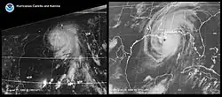
Although Hurricane Camille and Hurricane Katrina took different paths, both reached the same section of the coast of Mississippi with similar destructive effects. Camille intensified more rapidly than Katrina, and unlike Katrina, Camille re-intensified a second time and maintained status as a Category 5 hurricane until landfall. Both hurricanes shared the common aspect of undergoing periods of rapid intensification.[64] The size of Camille's radius of maximum wind was less than one-third that of Katrina, more similar to the intense but small Hurricane Andrew. Also unlike Katrina, Camille caused little damage in New Orleans, Louisiana, though Camille itself just barely missed the city.[65] The area of hurricane-force winds within Camille was just over two-thirds the size of Hurricane Katrina. Both storms were moving at a similar forward motion at the time of landfall. Although Camille's wind speed at landfall was higher, Katrina's storm surge exceeded Camille's storm surge at all known locations due to its greater size.[66]
Naming background
In the 1960s, there were four lists of feminine given names used for Atlantic hurricanes, with each list being used every fourth year.[67] The practice of retiring hurricane names was meant to be temporary, with the guideline that a name be retired for ten years. When the name Carla was retired in 1961, it was replaced on the 1965 list with Carol, a name retired in 1954 when its namesake devastated New England. Since over a decade had passed, Carol was eligible for reuse. Carol entered the 1969 list, but scientists from the National Hurricane Research Laboratory (NHRL) asked the naming committee in January 1969 to permanently retire Carol, Edna, and Hazel since papers were still being written about the storms. The committee agreed but needed a replacement "C" name. John Hope's daughter Camille was involved in an advanced science and math program in high school and had carried out a required independent research project. John Hope asked Banner Miller to mentor her in her investigation of hurricanes and long-term atmospheric trends. Miller was impressed by her project and suggested her name for the list. "We kept it quiet for many years," Camille said in a circa 2014 interview.[61]
In popular culture
Films
- A Lady Called Camille (1971), created by the U.S. Department of Agriculture shortly after the hurricane, shows preparation and recovery efforts organized largely by Wade Guice, the former Harrison County Civil Defense Director whose wife, Julia, served as Biloxi Civil Defense Director at the time. The couple are seen at their posts at the outset of the film. The film also contains brief footage of the ill-fated Richilieu Apartments after the hurricane, where a Civil Defense worker had attempted to persuade residents to evacuate. The film is accessible in the Internet Archive FedFlix collection.[68]
- The short film Camille and the Seabees (1971) is available for free viewing and download at the Internet Archive.
- Hurricane, a 1974 ABC made-for-TV disaster movie starring Frank Sutton and Larry Hagman. It contained references to the Richilieu Apartments and the Hurricane Hunter plane that flew into the eye of Camille and lost an engine, along with news footage from the hurricane.[69]
Music
- Jazz Banjo player Béla Fleck wrote a jazz fusion song "Hurricane Camille" on his album Béla Fleck and the Flecktones (1991).[70]
Publications
- Tom Clancy's novel Without Remorse (1993) opens with the demolition of an oil rig damaged during Camille.[71]
- Camille has an important role in the plot of John Grisham's novel The Boys from Biloxi. The book's protagonist begins his career a lawyer when persistently suing insurance companies which try to avoid paying for homes destroyed by Camille. Having established his reputation in this way, he eventually gets elected as District Attorney - leading to his head-on confrontation with organized crime which is the novel's main theme.
Stage productions
- Beth Henley's play Crimes of the Heart (1979) takes place in Hazlehurst, Mississippi and is set five years after Hurricane Camille.[72] While the hurricane is rarely mentioned in the script, it is cited as the cause of Doc Porter's limp and the reason Meg Magrath has been shunned by most of the town. The play was originally produced by the Actors Theatre of Louisville, Inc. in February 1979 and received its New York premiere at the Manhattan Theatre Club in 1980.[73][74]
- In 2008, Lynchburg, Virginia-based Endstation Theatre Company (then based in Amherst, Virginia) premiered an original play, The Bluest Water: A Hurricane Camille Story (by playwright Jason Chimonides), as part of its inaugural Blue Ridge Summer Theatre Festival on the campus of Sweet Briar College.[75] While the play was partly historical fiction (featuring contrived characters experiencing or remembering the actual events of Hurricane Camille), many characters' stories or lines of dialogue were composites of true accounts or testimonials from Nelson County (most notably Massies Mill, the Tye River, and Davis Creek) and the surrounding areas. The play was revived in the festival's second year (2009), in conjunction with the Nelson County Historical Society's observation of the 40th anniversary of Camille.[76]
Television
- In the October 2, 1991, episode of the NBC series Quantum Leap, titled "Hurricane" (Season 4, Episode 3), the main character, Sam Beckett, leaps into Archie Necaise, a small-town sheriff in the middle of Hurricane Camille. He must keep his host's girlfriend from being killed in the storm.[77]
- In the 1978 documentary series When Havoc Struck presented by Glenn Ford, one episode was titled 'Hurricane Camille'.[78]
See also
- Other storms of the same name
- List of Atlantic hurricane records
- List of Category 5 Atlantic hurricanes
- List of wettest known tropical cyclones in Virginia
- List of retired Atlantic hurricane names
- Hurricane Katrina (2005) – Category 5 hurricane that devastated similar areas, becoming the costliest tropical cyclone worldwide
- Hurricane Michael (2018) – Category 5 hurricane that struck the Gulf Coast of the United States
- Hurricane Helene (2024) - A deadly and devastating tropical cyclone that caused a path of widespread catastrophic damage and fatilites in the southeastern United States and also caused devastating flooding while inland in Western North Carolina
- Ginger Gold – apple variety originating in Nelson County, Virginia, and first identified in the aftermath of Hurricane Camille[79]
References
- ^ Relief, United States Congress Senate Committee on Public Works Special Subcommittee on Disaster (1970). Federal Response to Hurricane Camille: Hearings, Ninety-first Congress, Second Session. U.S. Government Printing Office.
- ^ Control, United States Congress House Committee on Public Works Subcommittee on Flood (1970). Disaster Assistance Legislation: Hearings, Ninety-first Congress, Second Session, on H.R. 17518 and Related Bills ... July 28, 29, 30, 1970. U.S. Government Printing Office.
- ^ a b Costliest U.S. tropical cyclones tables updated (PDF) (Report). Miami, Florida: National Hurricane Center. January 26, 2018. Retrieved February 1, 2018.
- ^ DeAngelis, Richard M. (January 1970). "North Atlantic Tropical Cyclones, 1969". Mariners Weather Log. 14 (1): 2.
- ^ a b c d e f g h i j k l m n o p q r Simpson, R. H.; Arnold L. Sugg (April 1970). "The Atlantic Hurricane Season of 1969" (PDF). Monthly Weather Review. 98 (4): 293. Bibcode:1970MWRv...98..293S. doi:10.1175/1520-0493-98.4.293 (inactive July 12, 2025). S2CID 123713109. Retrieved January 1, 2014.
{{cite journal}}: CS1 maint: DOI inactive as of July 2025 (link) - ^ a b c d e f g h i j k "Hurricane Camille Preliminary Report" (PDF). U.S. Department of Commerce. September 1969. Retrieved February 28, 2009.
- ^ a b c d "Atlantic hurricane best track (HURDAT version 2)" (Database). United States National Hurricane Center. May 11, 2024.
 This article incorporates text from this source, which is in the public domain.
- Landsea, Chris (April 2022). "The revised Atlantic hurricane database (HURDAT2) - Chris Landsea – April 2022" (PDF). Hurricane Research Division – NOAA/AOML. Miami: Hurricane Research Division – via Atlantic Oceanographic and Meteorological Laboratory.
{{cite web}}: CS1 maint: ref duplicates default (link)
- Landsea, Chris (April 2022). "The revised Atlantic hurricane database (HURDAT2) - Chris Landsea – April 2022" (PDF). Hurricane Research Division – NOAA/AOML. Miami: Hurricane Research Division – via Atlantic Oceanographic and Meteorological Laboratory.
- ^ a b c d National Hurricane Center; Hurricane Research Division; Atlantic Oceanographic and Meteorological Laboratory (March 2014). "Atlantic hurricane best track (HURDAT) Meta Data". United States National Oceanic and Atmospheric Administration's Office of Oceanic & Atmospheric Research. Archived from the original on June 4, 2011. Retrieved March 26, 2014.
- ^ a b c Kieper, Margaret E.; Landsea, Christopher W.; Beven, John L. (March 1, 2016). "A Reanalysis of Hurricane Camille" (PDF). Bulletin of the American Meteorological Society. 97 (3): 367–384. Bibcode:2016BAMS...97..367K. doi:10.1175/BAMS-D-14-00137.1. Retrieved October 19, 2024.
- ^ Blake, Eric S., Edward N. Rappaport, and Chris Landsea. The Dealiest, Costliest, and Most Intense United States Tropical Cyclones From 1851 to 2006 (and other frequently requested hurricane facts). Retrieved on March 19, 2008.
- ^ Kieper, Margaret E., Christopher W. Landsea, and John L. Beven II (March 2016). "A Reanalysis Of Hurricane Camille". Bulletin of the American Meteorological Society. 97 (3): 377. Bibcode:2016BAMS...97..367K. doi:10.1175/BAMS-D-14-00137.1.
{{cite journal}}: CS1 maint: multiple names: authors list (link) - ^ a b c Staff Writer (August 17, 1969). "Cuba Faces Big Problem From Storm". Newspapers.com. The Progress-Index. Retrieved August 11, 2025.
- ^ a b c d e Sullivan, Charles L. (1985). Hurricanes of the Mississippi Gulf Coast: 1717 to Present. Gulf Publishing Company, Inc.: pp. 93-118.
- ^ a b c d e f g h J. D. Camp; E. M. Miller, eds. (1970). Flood of August 1969 in Virginia (PDF) (Report). p. 6-7. Retrieved August 18, 2025.
- ^ Roth, David M. (October 30, 2007). "Hurricane Camille Rainfall Graphic". Hydrometeorological Prediction Center. Retrieved December 25, 2007.
- ^ Harrison County Library System (July 14, 2009). "Harrison County Camille Information". Archived from the original on September 1, 2009. Retrieved December 26, 2009.
- ^ Landsea, Chris (2007). "The Deadliest, Costliest, and Most Intense United States Hurricanes from 1900 to 2000 (And Other Frequently Requested Hurricane Facts)". Atlantic Oceanographic and Meteorological Laboratory. Retrieved December 26, 2009.
- ^ a b "Florida Braces for Big Blow". The Kingston Gleaner. Associated Press. August 16, 1969. Retrieved March 2, 2009.
- ^ "Hurricane Smashes Mississippi Coast". newspapers.com. Associated Press. August 18, 1969. Retrieved August 11, 2025.
- ^ a b Pielke Jr., Roger A.; et al. (August 2003). "Hurricane Vulnerability in Latin America and The Caribbean: Normalized Damage and Loss Potentials" (PDF). National Hazards Review. Archived from the original (PDF) on November 19, 2012. Retrieved January 1, 2014.
- ^ a b Minerals Management Service Gulf Coast Region (August 3, 2004). "History of the Offshore Oil and Gas Industry in Southern Louisiana Interim Report: Volume I: Papers on the Evolving Offshore Industry" (PDF). United States Department of the Interior. Archived from the original (PDF) on March 19, 2009. Retrieved March 10, 2009.
- ^ Richard J. Pasch; Robbie Berg; David P. Roberts; Philippe P. Papin (May 26, 2021). "Hurricane Laura" (PDF). Tropical Cyclone Report. Miami, Florida: National Hurricane Center. Retrieved August 10, 2025.
- ^ Roth, David M. (1998). Louisiana Hurricane History: Late 20th Century (continued). Archived January 13, 2007, at the Wayback Machine National Weather Service Southern Region Headquarters. Retrieved on March 13, 2009.
- ^ a b U.S. Army Corps of Engineers Mobile District (May 1970). "HURRICANE CAMILLE" (PDF). Retrieved August 7, 2025.
- ^ US Department of Commerce, NOAA. "Camille Storm Surge: Measured and High Water Marks Louisiana Map". www.weather.gov. Retrieved August 10, 2025.
- ^ a b c Roth, David M. (2009). Tropical Cyclone Rainfall for the Gulf Coast. Hydrometeorological Prediction Center. Retrieved on March 13, 2009.
- ^ "PARISH RESTORATION IS UNDERWAY". The Plaquemines Gazette. August 29, 1969. Retrieved August 14, 2025.
- ^ "New Law Assures Federal Funds for School Repairs". The Plaquemines Gazette. August 29, 1969. Retrieved August 13, 2025.
- ^ "Hurricane Most Vicious in History". The Louisiana Weekly. August 23, 1969. p. 9. Retrieved August 4, 2025.
- ^ "Louisiana Digital Media Archive". ladigitalmedia.org. Retrieved August 4, 2025.
- ^ Howard, Judith A.; Zebrowski, Ernest (2005). Category 5: The Story of Camille. Ann Arbor: University of Michigan Press. p. 109. ISBN 978-0-472-11525-9.
- ^ "See vintage photos of Hurricane Camille from 1969". NOLA.com. August 16, 2019. Retrieved August 7, 2025.
- ^ a b US Department of Commerce, NOAA. "Hurricane Camille - August 17, 1969". www.weather.gov. Retrieved August 7, 2025.
- ^ "Frank-Lloyd-Wright.com, FLW Designs (2005)". pp. "Enduring Legacy" (bottom). Archived from the original on August 7, 2007. Retrieved September 4, 2006.
- ^ Robert Morton, Kristy Guy, and Anne Whitko, Tiffany Pascoe, and Heather Hill (2007). Morphological Impacts of Hurricane Camille (1969) On Barrier Islands of Mississippi and Western Alabama. Archived May 6, 2009, at the Wayback Machine United States Geological Survey. Retrieved on March 13, 2009.
- ^ "Pearl River College Timeline | Pearl River Community College". June 30, 2022. Retrieved August 17, 2025.
- ^ "Hurricane Camille Causes Possible $40 Million in Damages to County Last Sunday Night". The Weekly Democrat. August 21, 1969. pp. 1–3. Retrieved May 10, 2025.
- ^ "Area to the south took ugly beating". Hattiesburg American. August 21, 1969. p. 1. Retrieved May 10, 2025.
- ^ Jacobs, Dennis M. (May 2007). "FOREST INVENTORY, CATASTROPHIC EVENTS AND HISTORIC GEOSPATIAL ASSESSMENTS IN THE SOUTH" (PDF). Archived from the original (PDF) on February 16, 2017. Retrieved May 9, 2025.
- ^ "Jackson County Agricultural Losses Noted". Sun Herald. August 23, 1969. p. 7. Retrieved May 10, 2025.
- ^ "Pecan Crop Destroyed in the Lumberton Area". Enterprise-Journal. September 9, 1969. p. 1. Retrieved May 10, 2025.
- ^ Ellis, Dan. "Hurricane Party". Retrieved March 4, 2015.
- ^ Fitzpatrick, Pat. "Hurricanes: A Reference Handbook". Retrieved June 27, 2018.
- ^ Roth, David M. (May 12, 2022). "Tropical Cyclone Rainfall in Florida". Tropical Cyclone Rainfall. United States Weather Prediction Center. Retrieved January 6, 2023. This article incorporates text from this source, which is in the public domain.
- ^ a b David Roth. "Hurricane Camille". Weather Prediction Center. Retrieved August 18, 2025.
- ^ Francis K. Schwarz (November 1970). "The Unprecedented Rains in Virginia Associated with the Remnants of Hurricane Camille" (PDF). Monthly Weather Review. 98 (11).
- ^ Adrian J. O'Connor (August 30, 2019). "'House, family ... gone': Remembering Hurricane Camille 50 years later". The Winchester Star. Retrieved August 18, 2025.
- ^ "Thirty Years After Hurricane Camille: Lessons Learned, Lessons Lost". Center for Science and Technology Policy Research. Retrieved August 18, 2025.
- ^ a b c Williams, Garnett P. and Harold P. Guy. Erosional and Depositional Aspects of Hurricane Camille in Virginia, 1969. United States Government Printing Office, 1973, pp. 1.
- ^ "Remembering the victims of Hurricane Camille in Nelson County". NewsAdvance.com. August 10, 2019. Retrieved December 10, 2020.
- ^ Provence, Lisa. "Flooded with Memories". The Hook. Archived from the original on March 25, 2015. Retrieved November 7, 2013.
- ^ United States Department of Commerce (1969). "Hurricane Camille August 14–22, 1969" (PDF). Environmental Science Services Administration. Retrieved March 23, 2008.
- ^ a b c d "The Inflation Calculator". Archived from the original on July 1, 2007. Retrieved June 18, 2006.
- ^ United States Department of Commerce (1969). "Hurricane Camille August 14–22, 1969" (PDF). Environmental Science Services Administration. Retrieved December 26, 2009.
- ^ Virginia Department of Emergency Management (2009). "Virginia's Weather History". Archived from the original on September 4, 2005. Retrieved May 28, 2006.
- ^ a b c Roger A. Pielke Jr.; Chantal Simonpietri; Jennifer Oxelson (July 12, 1999). "Thirty Years After Hurricane Camille: Lessons Learned, Lessons Lost". University of Colorado. Retrieved December 26, 2009.
- ^ "Four die in crash of plane". Hattiesburg American. August 20, 1969. Retrieved August 20, 2025.
- ^ Department of Commerce (September 1969). "Hurricane Camille: A Report to the Administrator" (PDF). Environmental Science Services Administration. p. vii. Archived from the original (PDF) on April 29, 2017. Retrieved June 3, 2017.
- ^ Drye, Willie (December 20, 2005). ""Category Five": How a Hurricane Yardstick Came to Be". National Geographic. Archived from the original on January 1, 2006. Retrieved July 30, 2006.
- ^ "Tropical Cyclone Naming History and Retired Names". Miami, Florida: National Hurricane Center. Retrieved February 16, 2024.
- ^ a b "45th Anniversary of Hurricane Camille". Miami, Florida: NOAA Hurricane Research Division. August 14, 2014. Retrieved February 16, 2024.
- ^ National Hurricane Operations Plan (PDF) (Report). Washington, D.C.: NOAA Office of the Federal Coordinator for Meteorological Services and Supporting Research. May 1971. p. 96. Retrieved February 16, 2024.
- ^ a b Landsea, Chris; Anderson, Craig; Bredemeyer, William; et al. (February 2024). Detailed List of Continental United States Hurricane Impacts/Landfalls 1851-1970, 1983-2023. Re-Analysis Project (Report). Miami, Florida: Atlantic Oceanographic and Meteorological Laboratory, Hurricane Research Division.
- ^ Jay S. Hobgood (2006). 16C.7: A comparison of hurricanes Katrina (2005) and Camille (1969). American Meteorological Society's 27th Conference on Hurricanes and Tropical Meteorology. Retrieved on March 13, 2009.
- ^ Stefan Bechtel (2006). Roar of the Heavens. Stefan Bechtel, pp. 279. ISBN 978-0-8065-2706-2. Retrieved on March 13, 2009.
- ^ Hermann M. Fritz, Chris Blount, Robert Sokoloski, Justin Singleton, Andrew Fuggle, Brian G. McAdoo, Andrew Moore, Chad Grass, Banks Tate (2007). Hurricane Katrina storm surge distribution and field observations on the Mississippi Barrier Islands. Estuarine, Coastal and Shelf Science Volume 74, pp. 14-20. Retrieved on March 13, 2009.
- ^ Padgett, Gary (2008). August 2007 (Monthly Global Tropical Cyclone Summary). Archived from the original on June 6, 2011. Retrieved May 28, 2014.
- ^ A Lady Called Camille. Internet Archive. 1971.
- ^ Hurricane at the TCM Movie Database
- ^ Béla Fleck and the Flecktones at AllMusic
- ^ Clancy, Tom (1993). "Prologue". Without Remorse. Penguin Books. ISBN 9781101002315. Retrieved August 15, 2018.
- ^ Frank, Leah D. (November 3, 1985). "THEATER REVIEW; STAGE: 'CRIMES OF THE HEART'". The New York Times. Retrieved August 15, 2018.
- ^ "'Crimes of the Heart' 1979, Actors Thratre" Archived November 19, 2015, at the Wayback Machine actorstheatre.org, accessed November 18, 2015
- ^ "'Crimes of the Heart' 1980" Archived November 19, 2015, at the Wayback Machine lortel.org, accessed November 18, 2015
- ^ Endstation Theatre Company. "2008 Season".
- ^ "Nelson County Historical Society". nchsva. 2009.
- ^ Hurricane. Quantum Leap. NBC.
- ^ "When Havoc Struck – Episode Guide". TV Guide. Retrieved August 15, 2018.
- ^ "Hurricane Camille Leaves a New Apple in Nelson C." Charlottesville Daily Progress, September 18, 1992
Further reading
- Bechtel, Stefan (2006). Roar Of The Heavens: Surviving Hurricane Camille. New York: Citadel Press. ISBN 978-0-8065-2706-2.
- Hearn, Philip D. (2004). Hurricane Camille: Monster Storm of the Gulf Coast. Jackson, Mississippi: Univ. Press of Mississippi. ISBN 978-1-57806-655-1.
External links
- Face to Face with Hurricane Camille, Joseph P. Blank, Reader's Digest (March 1970), pp 62–67
- Harrison County Library's Camille Page
- Post-Storm Report on Camille
- Radar image of Camille
- Storm surge profile
- The story of Harbour Oaks Inn
- Thirty Years After Hurricane Camille: Lessons Learned, Lessons Lost, Roger A. Pielke Jr., Chantal Simonpietri, and Jennifer Oxelson, July 12, 1999.
- Track of Camille's eye at landfall
| 1950s | |
|---|---|
| 1960s | |
| 1970s | |
| 1980s | |
| 1990s | |
| 2000s |
|
| 2010s | |
| 2020s | |
| |
| 1920s |
|
|---|---|
| 1930s |
|
| 1940s |
|
| 1950s | |
| 1960s | |
| 1970s | |
| 1980s | |
| 1990s | |
| 2000s | |
| 2010s | |
| 2020s | |
| |
Tropical cyclones of the 1969 Atlantic hurricane season | ||
|---|---|---|
 | ||
| ||