Horní Ves
Horní Ves | |
|---|---|
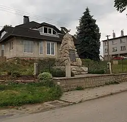 Memorial to the fallen of World War I | |
.svg.png) Flag  Coat of arms | |
 Horní Ves Location in the Czech Republic | |
| Coordinates: 49°17′36″N 15°18′27″E / 49.29333°N 15.30750°E | |
| Country | |
| Region | Vysočina |
| District | Pelhřimov |
| First mentioned | 1364 |
| Area | |
• Total | 9.24 km2 (3.57 sq mi) |
| Elevation | 598 m (1,962 ft) |
| Population (2025-01-01)[1] | |
• Total | 324 |
| • Density | 35/km2 (91/sq mi) |
| Time zone | UTC+1 (CET) |
| • Summer (DST) | UTC+2 (CEST) |
| Postal code | 394 03 |
| Website | www |
Horní Ves (German: Oberdorf) is a municipality and village in Pelhřimov District in the Vysočina Region of the Czech Republic. It has about 300 inhabitants.
Horní Ves lies on the Jihlava River, approximately 18 kilometres (11 mi) south-east of Pelhřimov, 24 km (15 mi) south-west of Jihlava, and 110 km (68 mi) south-east of Prague.
Demographics
| Year | Pop. | ±% |
|---|---|---|
| 1869 | 633 | — |
| 1880 | 615 | −2.8% |
| 1890 | 686 | +11.5% |
| 1900 | 653 | −4.8% |
| 1910 | 683 | +4.6% |
| 1921 | 752 | +10.1% |
| 1930 | 645 | −14.2% |
| 1950 | 485 | −24.8% |
| 1961 | 510 | +5.2% |
| 1970 | 455 | −10.8% |
| 1980 | 395 | −13.2% |
| 1991 | 382 | −3.3% |
| 2001 | 359 | −6.0% |
| 2011 | 288 | −19.8% |
| 2021 | 309 | +7.3% |
| Source: Censuses[2][3] | ||
References
- ^ "Population of Municipalities – 1 January 2025". Czech Statistical Office. 2025-05-16.
- ^ "Historický lexikon obcí České republiky 1869–2011" (in Czech). Czech Statistical Office. 2015-12-21.
- ^ "Population Census 2021: Population by sex". Public Database. Czech Statistical Office. 2021-03-27.
External links
Wikimedia Commons has media related to Horní Ves.