Grešlové Mýto
Grešlové Mýto | |
|---|---|
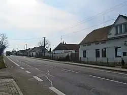 Main street | |
 Flag  Coat of arms | |
 Grešlové Mýto Location in the Czech Republic | |
| Coordinates: 48°58′51″N 15°53′10″E / 48.98083°N 15.88611°E | |
| Country | |
| Region | South Moravian |
| District | Znojmo |
| First mentioned | 1700 |
| Area | |
• Total | 2.16 km2 (0.83 sq mi) |
| Elevation | 384 m (1,260 ft) |
| Population (2025-01-01)[1] | |
• Total | 215 |
| • Density | 100/km2 (260/sq mi) |
| Time zone | UTC+1 (CET) |
| • Summer (DST) | UTC+2 (CEST) |
| Postal code | 671 56 |
| Website | www |
Grešlové Mýto (German: Gröschlmaut) is a municipality and village in Znojmo District in the South Moravian Region of the Czech Republic. It has about 200 inhabitants.
Grešlové Mýto lies on the Jevišovka River, approximately 18 kilometres (11 mi) north-west of Znojmo, 59 km (37 mi) south-west of Brno, and 163 km (101 mi) south-east of Prague.
Demographics
| Year | Pop. | ±% |
|---|---|---|
| 1869 | 226 | — |
| 1880 | 234 | +3.5% |
| 1890 | 231 | −1.3% |
| 1900 | 224 | −3.0% |
| 1910 | 252 | +12.5% |
| 1921 | 265 | +5.2% |
| 1930 | 264 | −0.4% |
| 1950 | 258 | −2.3% |
| 1961 | 309 | +19.8% |
| 1970 | 277 | −10.4% |
| 1980 | 227 | −18.1% |
| 1991 | 186 | −18.1% |
| 2001 | 193 | +3.8% |
| 2011 | 191 | −1.0% |
| 2021 | 195 | +2.1% |
| Source: Censuses[2][3] | ||
References
- ^ "Population of Municipalities – 1 January 2025". Czech Statistical Office. 2025-05-16.
- ^ "Historický lexikon obcí České republiky 1869–2011" (in Czech). Czech Statistical Office. 2015-12-21.
- ^ "Population Census 2021: Population by sex". Public Database. Czech Statistical Office. 2021-03-27.
External links
Wikimedia Commons has media related to Grešlové Mýto.