Glen Canyon National Recreation Area
| Glen Canyon National Recreation Area | |
|---|---|
 Reflection Canyon | |
| Location | Kane, San Juan, Garfield, and Wayne counties, Utah & Coconino County, Arizona, United States[1] |
| Nearest city | Page, Arizona, Bullfrog, Utah |
| Coordinates | 36°59′37″N 111°29′13″W / 36.99361°N 111.48694°W |
| Area | 1,254,117 acres (5,075.23 km2)[2] |
| Established | October 27, 1972 |
| Visitors | 5,206,934 (in 2023)[3] |
| Governing body | National Park Service, Bureau of Reclamation |
| Website | Glen Canyon National Recreation Area |
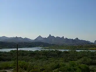
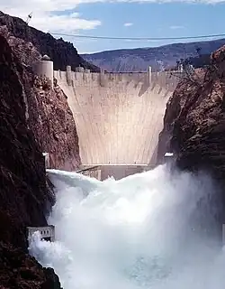
Glen Canyon National Recreation Area (shortened to Glen Canyon NRA or GCNRA) is a national recreation area and conservation unit of the United States National Park Service that encompasses the area around Lake Powell and lower Cataract Canyon in Utah and Arizona, covering 1,254,429 acres (5,076.49 km2) of mostly rugged high desert terrain. The recreation area is named for Glen Canyon, which was flooded by the Glen Canyon Dam, completed in 1966, and is now mostly submerged beneath the waters of Lake Powell.
Glen Canyon NRA borders Capitol Reef National Park and Canyonlands National Park on the north, Grand Staircase–Escalante National Monument on the west, Vermilion Cliffs National Monument and the northeasternmost reaches of Grand Canyon National Park on the southwest, and the Navajo Nation on the southeast. The southwestern end of Glen Canyon NRA in Arizona can be accessed via U.S. Route 89 and State Route 98. State Route 95 and State Route 276 lead to the northeastern end of the recreation area in Utah.
Glen Canyon NRA was established "to provide for public use and enjoyment and to preserve the area's scientific, historic, and scenic features." The stated purpose of Glen Canyon NRA is for recreation as well as preservation (whereas a national park may carry more emphasis on natural preservation). As such, the area has been developed for access to Lake Powell via five marinas, four public campgrounds, two small airports, and numerous houseboat rental concessions.
Administrative History

In February 1957 Utah Senator Arthur V. Watkins requested Secretary of the Interior Fred A. Seaton study the possibility of a national recreation area at the reservoir formed by Glen Canyon Dam.[4] In June 1958, the National Park Service and the Bureau of Reclamation agreed on administration and development of the upstream and downstream areas of the Colorado River either side of Glen Canyon Dam. The area, according to Secretary Seaton, would be designated the Glen Canyon National Recreation Area.[5]
In January 1959, President Dwight D. Eisenhower proposed a budget that included $43,500 for the construction of roads in Glen Canyon NRA. That March, the National Park Service announced plans for GCNRA including the expenditure of $16.5 million over the next 10 to 15 years.[6] In April 1959, a Department of Interior source stated James Milford Eden, Superintendent of Organ Pipe Cactus National Monument, would be named the first Superintendent of GCNRA.[7] That May, Eden set up office in a trailer near what would become today’s Wahweap Marina.[8] That October, the National Parks Advisory Board toured Glen Canyon Dam. Superintendent Eden was on the tour, accompanied by Frank Masland Jr., Chairman of the Advisory Board.[9]
In March 1960, Eden presented a map of the tentative boundaries of GCNRA, including the road to Lees Ferry from Highway 89 and lands just west and south of the northwest side of Navajo Bridge.[10] On June 1, 1960, GCNRA received a used WWII 24-ton LCM Landing Craft Mechanized from the U.S. Navy. It was the second boat the new Recreation area had, the first was a “trim little boat” called the Park Ranger.[11] The Park Service opened the campground at Wahweap Marina on December 6, 1961. It had 57 camping sites. [12] In July 1962, GCNRA let out bids for construction of NPS housing in Page, Arizona and at Wahweap Marina.[13]
In September 1962, the US Senate Public Works Commission authorized $3,000,000 for a bridge to cross the Colorado River just upstream from the confluence with the Dirty Devil River.[14] That November, GCNRA let bids to operate a concessions contract for the operation of a marina near the bridge called Hite Marina. Recreation facilities at Lees Ferry were also planned.[15][16] In August 1963, Utah Senator Frank Moss introduced legislation to create Glen Canyon National Recreation Area. The area in Moss’s Bill encompassed 1,430,000 acres of land and intended to establish by law the recreation area designated by the Interior Order of 1958. [17] The final bill passed by Congress, Public Law 92-593, was for 1,236,880 acres and was signed into law by President Richard Nixon on October 27, 1972.[18]
Geology
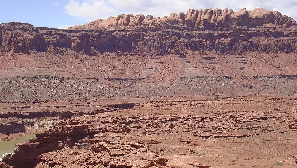
The geology of the area is dominated by the Glen Canyon Group, consisting of the Navajo Sandstone, Kayenta Formation, and Wingate Sandstone.[19] The entire stratigraphic section includes rocks dating from the Cretaceous to Pennsylvanian periods.[20]
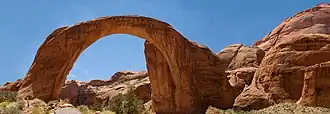
Double Arch
A well-known rock formation named the Double Arch existed over Lake Powell. It collapsed on August 8, 2024.[21]
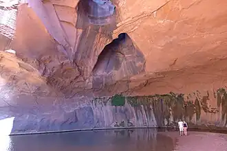
Recreation
Lake Powell has nearly 2,000 miles (3,200 km) of fish-holding shoreline and provides opportunities to fish for largemouth bass, smallmouth bass, and striped bass that swim in the waters of the recreation area.
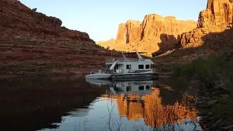
Several local marinas and sports outfitters provide houseboats, powerboats, jet skis, kayaks, fishing gear, and related equipment to visitors.
Graffiti Removal and Intervention Team (GRIT)
With millions of visitors to the recreation area each year, it is inevitable that vandals will deface the rock faces of the canyon. Glen Canyon NRA has implemented a voluntourism program wherein volunteers sign up for a five-day houseboat trip during which they help remove graffiti from the canyon walls.[22]
See also
References
- ^ "NPS Geodiversity Atlas—Glen Canyon National Recreation Area, Arizona and Utah". National Park Service. Retrieved 2024-09-29.
Glen Canyon National Recreation Area is located [...] in Garfield, Kane, San Juan, and Wayne Counties, Utah, and Coconino County, Arizona.
- ^ "Listing of acreage – December 31, 2011" (XLSX). Land Resource Division, National Park Service. Retrieved 2012-12-14. (National Park Service Acreage Reports)
- ^ "NPS Annual Recreation Visits Report". National Park Service. Retrieved 2024-04-11.
- ^ “Glen Canyon National Recreation Area Proposal,” American Fork Citizen, Feb 7, 1957
- ^ “Recreation Area Program Drawn,” Albuquerque Journal, June 25, 1958
- ^ “Park Service Announces Glen Plans,” Deseret News, March 2, 1959
- ^ “Wins Glen Recreation Post,” Salt Lake Tribune, April 21, 1959
- ^ “Park Service Project Chief In Page To Begin Planning,” Arizona Daily Sun, May 11, 1959
- ^ “National Park Advisory Board Visits Page, Walks Bridge, Sees New Tunnels,” Arizona Daily Sun, Oct 13, 1959
- ^ “Planning Well Underway On Lake Powell Rec Area,” Arizona Daily Sun, March 23, 1960
- ^ “Desert, Rocks Everywhere, Park Service Has A Boat,” Arizona Daily Sun, June 1, 1960
- ^ “Wahweap Camp Area Open To The Public, Arizona Republic, December 6, 1961
- ^ “Bids Asked In Page Area,” Arizona Republic, July 14, 1962
- ^ “Senate Committee Approves Funds For Hite Bridge,” Richfield Reaper, September 6, 1962
- ^ “Firms Seeking,” Tucson Citizen, November 9, 1962
- ^ ”Magazine Expanding Staff Here,” Arizona Daily Sun, January 19, 1966
- ^ “Bill Introduced For Recreation Area In S. Utah,” Arizona Daily Star, August 29, 1963
- ^ ”Consumer Protection Bill Among 30 OK’d By Nixon;” Tucson Citizen, October 28, 1972
- ^ "Summary of Geologic History". Archived from the original on 2009-12-26. Retrieved 2010-05-20.
- ^ "Stratigraphic Columns" (PDF). Nps.gov. Archived from the original (PDF) on 2017-02-09. Retrieved 2016-07-18.
- ^ Mayorquín, Orlando (2024-08-10). "Famed Double Arch Collapses in Glen Canyon National Recreation Area". The New York Times. ISSN 0362-4331. Archived from the original on 2024-08-12. Retrieved 2024-08-12.
- ^ "Graffiti Removal and Intervention Team". Glen Canyon NRA. National Park Service. Archived from the original on 2018-05-04. Retrieved 2018-05-03.
External links
- Official National Park Service site
- Official National Park Service Concessionaire Site Lake Powell Resorts & Marinas, managed by Aramark, is an authorized concessioner of the National Park Service, Glen Canyon National Recreation Area.
- Glen Canyon Conservancy
- Page Lake Powell Chamber of Commerce
Colorado River system | |||||||||
|---|---|---|---|---|---|---|---|---|---|
| Jurisdictions |
|     | |||||||
| Canyons |
| ||||||||
| Natural features |
| ||||||||
| Tributaries | |||||||||
| Engineering |
| ||||||||
| Designated areas | |||||||||
| Related topics | |||||||||