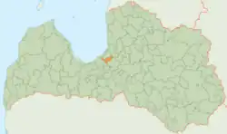
Garkalne Municipality
Garkalne Municipality
Garkalnes novads | |
|---|---|
 Flag 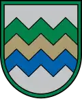 Coat of arms | |
 | |
| Country | |
| Formed | 2007 |
| Dissolved | 2021 |
| Centre | Berģi (extraterritorially) |
| Government | |
| • Council Chair (last) | Alvis Zīriņš (S) |
| Area | |
• Total | 152.50 km2 (58.88 sq mi) |
| • Land | 142.81 km2 (55.14 sq mi) |
| • Water | 9.69 km2 (3.74 sq mi) |
| Population (2021)[2] | |
• Total | 9,425 |
| • Density | 62/km2 (160/sq mi) |
| Website | www |
Garkalne Municipality (Latvian: Garkalnes novads) was a municipality in Vidzeme, Latvia. The municipality was formed in 2007 by reorganization of Garkalne Parish of Riga district. The seat of the council of the municipality was situated outside the municipality in Berģi, Riga. The population in 2020 was 8,923.[3]
On 1 July 2021, Garkalne Municipality ceased to exist and its territory was merged with Ropaži Municipality as Garkalne Parish.[4]
The main rivers were Lielā Jugla, Mazā Jugla (as a border river between Garkalne Municipality and Stopiņi Municipality), Krievupe, Jugla, in a small section of the river Tumšupe. The largest lakes in the region were Lielais Baltezers, Langstiņi Lake, Lielais Jūgezers, Mālezers, Mašēnu Lake and Upesciems Ponds. Maltuve Swamp is located in the eastern part of the territory.
See also
References
- ^ Central Statistical Bureau of Latvia https://data.stat.gov.lv/pxweb/lv/OSP_PUB/START__ENV__DR__DRT/DRT010/. Retrieved 25 February 2021.
{{cite web}}: Missing or empty|title=(help) - ^ Central Statistical Bureau of Latvia https://data.stat.gov.lv/pxweb/lv/OSP_PUB/START__POP__IR__IRS/IRD060/. Retrieved 15 June 2021.
{{cite web}}: Missing or empty|title=(help) - ^ "ISG020. Population number and its change by statistical region, city, town, 21 development centres and county". Central Statistical Bureau of Latvia. 2020-01-01. Retrieved 2021-02-12.
- ^ "Administratīvo teritoriju un apdzīvoto vietu likums". LIKUMI.LV (in Latvian). Retrieved 2024-08-08.
57°02′51″N 24°25′14″E / 57.04750°N 24.42056°E