Frasertown
Frasertown | |
|---|---|
 | |
| Coordinates: 38°58′S 177°24′E / 38.967°S 177.400°E | |
| Country | New Zealand |
| Region | Hawke's Bay |
| Territorial authority | Wairoa District |
| Ward |
|
| Electorates | |
| Government | |
| • Territorial authority | Wairoa District Council |
| • Mayor of Wairoa | Craig Little[1] |
| • Napier MP | Katie Nimon[2] |
| • Ikaroa-Rāwhiti MP | Cushla Tangaere-Manuel[3] |
| Area | |
• Total | 1.36 km2 (0.53 sq mi) |
| Population (June 2024)[5] | |
• Total | 240 |
| • Density | 180/km2 (460/sq mi) |
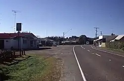
Frasertown is a small settlement in the northern Hawke's Bay Region of New Zealand's eastern North Island.
It is located inland from Wairoa at the junction of SH38, and the inland route (the Tiniroto Road; the former SH36) to Gisborne. State Highway 38 leads from Wai-O-Tapu via Murupara, The Ureweras, Lake Waikaremoana and Frasertown to Wairoa. It gives a short, but (partly) unsealed, winding and climbing connection to the Central North Island Rotorua. It is named for Major James Fraser, who led military forces in Wairoa in the 1860s.[6][7]
Demographics
Statistics New Zealand describes Frasertown as a rural settlement, which covers 1.36 km2 (0.53 sq mi).[4] It had an estimated population of 240 as of June 2024,[5] with a population density of 176 people per km2. It is part of the larger Frasertown-Ruakituri statistical area.[8]
| Year | Pop. | ±% p.a. |
|---|---|---|
| 2006 | 252 | — |
| 2013 | 213 | −2.37% |
| 2018 | 255 | +3.66% |
| 2023 | 240 | −1.21% |
| Source: [9][10] | ||
Frasertown had a population of 240 in the 2023 New Zealand census, a decrease of 15 people (−5.9%) since the 2018 census, and an increase of 27 people (12.7%) since the 2013 census. There were 114 males and 123 females in 90 dwellings.[11] 1.2% of people identified as LGBTIQ+. The median age was 45.2 years (compared with 38.1 years nationally). There were 42 people (17.5%) aged under 15 years, 42 (17.5%) aged 15 to 29, 99 (41.2%) aged 30 to 64, and 54 (22.5%) aged 65 or older.[9]
People could identify as more than one ethnicity. The results were 55.0% European (Pākehā), 61.2% Māori, 2.5% Pasifika, and 2.5% other, which includes people giving their ethnicity as "New Zealander". English was spoken by 96.2%, Māori by 16.2%, and other languages by 1.2%. No language could be spoken by 1.2% (e.g. too young to talk). New Zealand Sign Language was known by 1.2%. The percentage of people born overseas was 3.8, compared with 28.8% nationally.[9]
Religious affiliations were 28.8% Christian, and 18.8% Māori religious beliefs. People who answered that they had no religion were 41.2%, and 8.8% of people did not answer the census question.[9]
Of those at least 15 years old, 21 (10.6%) people had a bachelor's or higher degree, 120 (60.6%) had a post-high school certificate or diploma, and 57 (28.8%) people exclusively held high school qualifications. The median income was $30,400, compared with $41,500 nationally. 15 people (7.6%) earned over $100,000 compared to 12.1% nationally. The employment status of those at least 15 was 93 (47.0%) full-time, 24 (12.1%) part-time, and 6 (3.0%) unemployed.[9]
Frasertown-Ruakituri statistical area
Frasertown-Ruakituri statistical area, which also includes Ohuka and Ruakituri, covers 1,333.71 km2 (514.95 sq mi)[12] and had an estimated population of 910 as of June 2024,[13] with a population density of 0.68 people per km2.
| Year | Pop. | ±% p.a. |
|---|---|---|
| 2006 | 927 | — |
| 2013 | 861 | −1.05% |
| 2018 | 861 | +0.00% |
| 2023 | 879 | +0.41% |
| Source: [14][15] | ||
Frasertown-Ruakituri had a population of 879 in the 2023 New Zealand census, an increase of 18 people (2.1%) since the 2018 census, and an increase of 18 people (2.1%) since the 2013 census. There were 456 males, 420 females, and 3 people of other genders in 318 dwellings.[16] 1.0% of people identified as LGBTIQ+. The median age was 37.7 years (compared with 38.1 years nationally). There were 198 people (22.5%) aged under 15 years, 153 (17.4%) aged 15 to 29, 363 (41.3%) aged 30 to 64, and 165 (18.8%) aged 65 or older.[14]
People could identify as more than one ethnicity. The results were 67.2% European (Pākehā), 50.2% Māori, 1.7% Pasifika, and 1.4% other, which includes people giving their ethnicity as "New Zealander". English was spoken by 96.2%, Māori by 12.6%, Samoan by 0.3%, and other languages by 1.0%. No language could be spoken by 2.4% (e.g. too young to talk). New Zealand Sign Language was known by 0.3%. The percentage of people born overseas was 3.8, compared with 28.8% nationally.[14]
Religious affiliations were 25.9% Christian, 10.9% Māori religious beliefs, and 0.7% other religions. People who answered that they had no religion were 56.0%, and 7.2% of people did not answer the census question.[14]
Of those at least 15 years old, 75 (11.0%) people had a bachelor's or higher degree, 423 (62.1%) had a post-high school certificate or diploma, and 180 (26.4%) people exclusively held high school qualifications. The median income was $34,000, compared with $41,500 nationally. 45 people (6.6%) earned over $100,000 compared to 12.1% nationally. The employment status of those at least 15 was 354 (52.0%) full-time, 108 (15.9%) part-time, and 21 (3.1%) unemployed.[14]
Marae
The township includes a number of marae (meeting grounds) and wharenui (meeting houses) for the local iwi (tribe) of Ngāti Kahungunu and its hapū (sub-tribes):[17][18]
- Aranui Marae and Arapera or Te Poho o Ngapera wharenui, affiliated with Ngāi Tamaterangi and Ngāti Peehi hapū.
- Arimawha Marae, affiliates with Ngāti Tamaterangi hapū.
- Pākōwhai Marae and Te Huinga o Te Aroha wharenui, affiliated with Ngāti Mihi hapū.
- Pūtahi Marae and Te Poho o Hinepehinga wharenui, affiliated with Ngāti Hinepehinga hapū.
In October 2020, the Government committed $1,949,075 from the Provincial Growth Fund to upgrade all four marae and 20 other Ngāti Kahungunu marae, creating 164 jobs.[19]
Education
Frasertown School is a Year 1–6 co-educational state primary school.[20] It is a decile 4 school with a roll of 112 as of July 2025.[21][22] The school opened in 1868.[23]
References
- ^ "Mayor & Councillors". Wairoa District Council. Retrieved 18 August 2025.
- ^ "Napier - Official Result". Electoral Commission. 1 August 2025.
- ^ "Ikaroa-Rāwhiti – Official Result". New Zealand Electoral Commission. Retrieved 28 July 2025.
- ^ a b "Stats NZ Geographic Data Service". Urban Rural 2023 (generalised). Retrieved 18 August 2025.
- ^ a b "Aotearoa Data Explorer". Statistics New Zealand. Retrieved 26 October 2024.
- ^ Taonga, New Zealand Ministry for Culture and Heritage Te Manatu. "Wairoa". teara.govt.nz. Retrieved 20 February 2022.
- ^ "Major James Fraser | NZETC". nzetc.victoria.ac.nz. Retrieved 20 February 2022.
- ^ "Geographic Boundary Viewer". Stats NZ. Urban Rural – 2023 and Statistical Area 2 – 2023.
- ^ a b c d e "Totals by topic for individuals, (RC, TALB, UR, SA3, SA2, Ward, Health), 2013, 2018, and 2023 Censuses". Stats NZ – Tatauranga Aotearoa – Aotearoa Data Explorer. Frasertown (1282). Retrieved 3 October 2024.
- ^ "Statistical area 1 dataset for 2018 Census". Statistics New Zealand. March 2020. 7015759 and 7015760.
- ^ "Totals by topic for dwellings, (RC, TALB, UR, SA3, SA2, Ward, Health), 2013, 2018, and 2023 Censuses". Stats NZ – Tatauranga Aotearoa – Aotearoa Data Explorer. Retrieved 3 October 2024.
- ^ "Stats NZ Geographic Data Service". Statistical Area 2 2023 (generalised). Retrieved 18 August 2025.
- ^ "Aotearoa Data Explorer". Statistics New Zealand. Retrieved 26 October 2024.
- ^ a b c d e "Totals by topic for individuals, (RC, TALB, UR, SA3, SA2, Ward, Health), 2013, 2018, and 2023 Censuses". Stats NZ – Tatauranga Aotearoa – Aotearoa Data Explorer. Frasertown-Ruakituri (207600). Retrieved 3 October 2024.
- ^ "Statistical area 1 dataset for 2018 Census". Statistics New Zealand. March 2020. Frasertown-Ruakituri (207600). 2018 Census place summary: Frasertown-Ruakituri
- ^ "Totals by topic for dwellings, (RC, TALB, UR, SA3, SA2, Ward, Health), 2013, 2018, and 2023 Censuses". Stats NZ – Tatauranga Aotearoa – Aotearoa Data Explorer. Retrieved 3 October 2024.
- ^ "Te Kāhui Māngai directory". tkm.govt.nz. Te Puni Kōkiri.
- ^ "Māori Maps". maorimaps.com. Te Potiki National Trust.
- ^ "Marae Announcements" (Excel). growregions.govt.nz. Provincial Growth Fund. 9 October 2020.
- ^ "Ministry of Education School Profile". educationcounts.govt.nz. Ministry of Education.
- ^ "New Zealand Schools Directory". New Zealand Ministry of Education. Retrieved 1 July 2025.
- ^ "Education Review Office Report". ero.govt.nz. Education Review Office. Retrieved 18 August 2025.
- ^ "Frasertown School 125 Years 1868-1993". Hawkes Bay Digital Archives Trust. Retrieved 18 August 2025.