Florida Platform
The Florida Platform is a flat geological feature that underlies all of Florida and southern Alabama and Georgia and their adjacent continental shelves. The basement of the platform, composed of igneous, metamorphic, and sedimentary rocks, was originally part of the African continent that became attached to the North American continent in the Jurassic geological period. The basement rocks are overlain by up to 5 kilometres (3.1 mi) of evaporite, carbonate, and siliciclastic sedimentary deposits that are primarily of marine origin.
Description
The Florida Platform is a large, level, and relatively stable platform of sedimentary strata on the trailing or eastern edge of the North American continent, extending between the basins of the Gulf of Mexico and the Atlantic Ocean. It underlies all of Florida and its adjacent continental shelves, as well as the southern parts of Alabama and Georgia.[1] The basement of the platform was originally part of Africa that became attached to North America during the Ordivician Period as the supercontinent of Pangaea formed. The platform separated from Africa as Pangaea broke up in the Jurassic, remaining attached to North America.[2] The Florida Platform remained submerged for most of the Cenozoic Era, and the sedimentary strata of the platform are primarily of marine origin.[3]
Basement
Components
The basement of the Florida Platform comprises igneous, metamorphic, and sedimentary rocks of Proterozoic, Paleozoic, and Triassic age. The top of the basement of the platform is marked by an unconformal surface of pre-Middle Jurassic age overlain by evaporite, carbonate, and siliciclastic deposits of Middle Jurassic to Holocene ages. The top of the basement is approximately 915 metres (3,002 ft) below mean sea level (MSL) in the north-central Florida peninsula, and slopes downward on the east towards the Atlantic Ocean basin, on the west towards the Gulf of Mexico basin, and on the south towards the South Florida Basin, reaching 5,180 metres (16,990 ft) below MSL in southern Florida.[4]
Boreholes in northern Florida have reached sandstones and shales of early Paleozoic age lying 0.8 kilometres (0.50 mi) to 2.3 kilometres (1.4 mi) below the surface. The sediments are horizontal and have not undergone metamorphosis, although some may have been altered by hydrothermal processes. Many of the boreholes have recovered fossils of graptolites, brachiopods, trilobites, crinoids, molluscs, conodonts, palynomorphss, and chitinozoans. The faunal assemblages resemble African or South American assemblages, but none have resembled any North American assemblage. Bore holes have also penetrated granite and other volcanic rocks.[5]
Jay Fault
The basement rocks of the Florida Platform are divided into two regions by the Jay Fault that runs from southeastern Florida to the northwest across the Florida peninsula to north of Tampa Bay and then under the Gulf and across the western end of the Florida panhandle. The Jay Fault is part of a longer structure that includes the Bahamas Fracture Zone along the northeastern edge of the Bahamas Banks to the southeast and the Pickens-Gilberton Fault to the northwest in Alabama. To the northeast of the Jay Fault a batholith centered 1.7 to 2.4 kilometres (1.1 to 1.5 mi) beneath Osceola County has been named the Osceola Granite, and together with associated metamorphic and other volcanic rocks of early Paleozoic age extending into southern Georgia and the Florida panhandle, is known as the Osceola Complex. The Suwannee Basin sequence of middle Paleozoic sandstones and shales, which is up to 2.5 kilometres (1.6 mi) thick, overlies the Osceola Complex in northern Florida and southeastern Georgia. A complex graben system, known as the South Georgia Rift, Southwest Georgia Embayment, Apalachicola Embayment, or Tallahassee Graben, underlies much of the Florida panhandle and southern Georgia.[6]
Southwest of the Jay Fault in the southern part of the Florida peninsula the basement is primarily composed of the Mesozoic-age South Florida Volcanic Rocks. There is a wedge of metamorphic rocks, the St. Lucie Complex, southeast of the Jay Fault on the east coast adjacent to the Osceola Granite that is considered part of the Osceola Complex. Across the West Florida Continental shelf and southern Florida southwest of the Jay Fault there are several basins and arches at the top of the basement rocks discernible via seismic imaging. The Apalachicola Basin on the continental shelf is offshore of the Apalachicola Embayment or South Georgia Rift. It is bordered on the southeast in turn by the Middle Ground Arch, which extends across the Jay Fault under Apalachee Bay, The Tampa Basin, the Sarasota Arch, and the South Florida Basin.[7]
Origin
The Florida Platform originated in Gondwana in the early Paleozoic. Data from paleontology, isotope geochemistry, and paleomagnetism studies indicate that the platform was part of the western African continental margin near Senegal. The Tallahassee-Suwannee terrane (crustal fragment) that forms the basement under northern Florida and southern Georgia (northwest of the Jay Fault) contains rhyolitic rocks that correlate geochemically with rocks found in locations along the western margin of Africa. The St. Lucie metamorphic complex matches rocks of the Rokelide Orogen in Guinea. The Osceola Granite resembles the Coya Granite in Senegal. The Suwannee Basin sedimentary rocks have been correlated with those of the Bove Basin in Guinea-Bissau; the two features are likely remnants of an extensive basin.[8]
In the late Paleozoic Era, Laurentia (the core of what is now North America) converged on Gondwana, closing the Iapetus Ocean and creating the Pangaea supercontinent. The part of Gondwana facing Laurentia included what are now western Africa and northern South America. The collision created strike-slip faults in Gondwana as blocks of crust moved in response to irregularities in continental margins. There are several possible faults from this period in the basement of the Florida Platform, the most prominent being the Jay Fault.[9] The Brunswick Magnetic Anomaly, consisting of a northern negative component and a southern positive component, runs east-west across southern Georgia and Alabama. The anomaly is commonly believed to mark the boundary between the Florida Platform and the rest of North America. An alternative explanation for the anomaly is that the North American Plate was subducted under Gondwana as the Iapetus Ocean closed, and that the anomaly marks the lower end of the subducted North American lithosphere under the Tallahassee-Suwannee terrane (the northern part of the Florida Platform), the northern boundary of which may be as much as 100 kilometres (62 mi) north of the anomaly. Another proposal is that the Brunswick Magnetic Anomaly was a Mesozoic rift basin. It has also been proposed that the Florida Magnetic Anomaly, crossing the Florida peninsula approximately from Volusia County to Hernando County, marks the suture between North America and the Florida Platform.[10]
Rifting
Reconstructions of Pangaea place the Florida Platform at the junction of the African, North American, and South American continents. A system of rifts that would eventually produce the Atlantic Ocean began opening along the pre-Pangaea continental margins during the Triassic. The rifting is believed to have been initiated by hot spots, including one near the southern end of the Florida Platform. Isotopic signatures of the South Florida Volcanic Rocks indicate they were produced by a hot spot. The South Georgia Rift, a graben, started to form across what is now southern Georgia (along the pre-Pangaean margin between Africa and North America), but stopped and became an aulacogen, a failed arm of a triple junction. The rifting shifted, separating the Florida Platform and the Bahamas Banks from Africa and, with the Yucatán Platform,[a] from South America.[12]
North America began separating from South America in the early Jurassic, with the Gulf of Mexico opening in the early Jurassic, and the Yucatan Platform pivoting away from North America. Grabens and horsts in the basement of the western part of the Florida Platform may have developed due to stresses on the crust caused by the opening of the Gulf of Mexico, or may be horsts that broke off of North America and reattached to the Florida Platform. Similarly, horsts that broke off of South America may underlie southern Alabama and Mississippi. The Florida Platform has been tectonically quiet since the end of the rifting. There has been regional uplift in the sedimentary layers that have accumulated on the Florida Platform, but they are the product of epeirogenic movement caused by density changes resulting from dissolution of limestone.[12]
Post-basement sediments
Jurassic and Cretaceous sediments
Clastic sediments began accumulating in incipient rifts associated with the Florida Platform in the late Triassic and early Jurassic. As the Gulf of Mexico opened up in the middle Jurassic, carbonate, evaporite and siliciclastic sediments accumulated on the Florida Platform. The Apalachicola Embayment and Tampa Basin developed thick sediments of evaporite (related to the Louann Salt). Clastic sediments (Norphlet Sand) developed on top of the evaporates in the Northern part of the platform, and with a later rise in sea level, the Smackover Limestone was laid down.[13]
From the late Triasssic into the middle Jurassic, most of the Florida Platform was aboved sea level and no sedimentary strata have survived from that period. From the Late Jurassic through the Cretaceous Period, sea levels were higher than at present, and most of the platform was below sea level most of the time. The platform was a rimmed shelf during the Jurassic and until well into the Cretaceous. As sea levels rose and fell during glacial cycles, layers of carbonate and evaporite sediments were laid down on the submerged southern portions of the platform, while clastic deltaic and marine sediments were laid down on the western platform.[14]
During the late Jurassic and early Cretaceous, the Florida Platform was part of a very large carbonate platform complex known as the Bahamas - Grand Banks Gigaplatform, which stretched nearly 7,000 kilometres (4,300 mi) from the Bahamas Banks through the Florida Platform and up the coast of North America to Canada, three times longer than the Great Barrier Reef.[15]
Geology
The oldest sediments that are exposed are Eocene carbonates found in the Avon Park Formation. Most of the state of Florida is covered by Pliocene, Pleistocene, and Holocene siliciclastic-bearing sediments deposited during sea-level fluctuations and filling in of the Gulf Trough beginning in the late Tertiary and Quaternary.
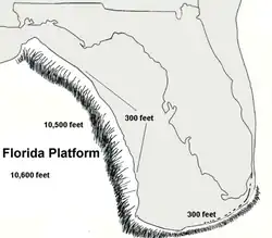
The platform's western edge, or Florida Escarpment, is normally defined where water depths at 300 feet (91 m) drop dramatically and in a short distance to 10,000 feet (3,000 m). The Florida peninsula is located on the eastern side of the platform, where in places it lies only 3 to 4 miles (4.8 to 6.4 km) from the platform's edge. On the gulf side the platform ends over 100 miles (160 km) to the west of the modern shoreline, where a massive cliff rises over 6,000 feet (1,800 m) from the 10,600 feet (3,200 m) depth of the gulf floor. The western reaches of the platform just off Tampa were explored by the submersible DSV Alvin in 1984 and the NOAAS Okeanos Explorer in 2018.[16][17] Examination has placed the depth of carbonate rocks at greater than 20,000 feet (6,100 m).
Notes
References
- ^ Scott 2011, p. 17–18.
- ^ Heatherington & Mueller 1997, pp. 34–35.
- ^ Schmidt 1997, p. 12.
- ^ Scott 2011, pp. 17–21.
- ^ Smith & Lord 1997, p. 14.
- ^ Smith & Lord 1997, pp. 13–15, 18.
- ^ Smith & Lord 1997, pp. 14–16.
- ^ Smith & Lord 1997, pp. 21–22.
- ^ Smith & Lord 1997, pp. 22–24.
- ^ Heatherington & Mueller 1997, pp. 27, 35–36.
- ^ Steiner, Maureen B. (2005), "Pangean reconstruction of the Yucatan Block: Its Permian, Triassic, and Jurassic geologic and tectonic history", in Anderson, Thomas H.; Nourse, Jonathan A.; McKee, James W.; Steiner, Maureen B. (eds.), The Mojave-Sonora Megashear Hypothesis:Development, Assessment, and Alternatives, Geological Society of America, Chapter abstract, ISBN 978-0-8137-2393-8
- ^ a b Smith & Lord 1997, pp. 24–25.
- ^ Randazzo 1997, p. 39.
- ^ Randazzo 1997, pp. 40, 44–45.
- ^ Hine 1997, pp. 169–170.
- ^ "History of Alvin - Woods Hole Oceanographic Institution". Retrieved June 27, 2025.
- ^ "NOAA Ship Okeanos Explorer: Gulf of Mexico 2018: NOAA Office of Ocean Exploration and Research". oceanexplorer.noaa.gov. Retrieved June 27, 2025.
Sources
- Heatherington, Ann L.; Mueller, Paul A. (1997). "Geochemistry and Origin of Florida Crustal Basement Terranes". In Randazzo, Anthony F.; Jones, Douglas S. (eds.). The Geology of Florida. Gainesville, Florida: University Press of Florida. pp. 27–38. ISBN 9780813014968.
- Hine, Albert C. (1997). "Structural and Paleoceanographic Evolution of the Margins of the Florida Platform". In Randazzo, Anthony F.; Jones, Douglas S. (eds.). The Geology of Florida. Gainesville, Florida: University Press of Florida. pp. 169–194. ISBN 9780813014968.
- Randazzo, Anthony F. (1997). "The Sedimentary Platform of Florida: Mesozoic to Cenozoic". In Randazzo, Anthony F.; Jones, Douglas S. (eds.). The Geology of Florida. Gainesville, Florida: University Press of Florida. pp. 39–56. ISBN 9780813014968.
- Schmidt, Walter (1997). "Geomorphology and Physiography of Florida". In Randazzo, Anthony F.; Jones, Douglas S. (eds.). The Geology of Florida. Gainesville, Florida: University Press of Florida. pp. 1–12. ISBN 9780813014968.
- Smith, Douglas L.; Lord, Kenneth M. (1997). "Tectonic Evolution and Geophysics of the Florida Basement". In Randazzo, Anthony F.; Jones, Douglas S. (eds.). The Geology of Florida. Gainesville, Florida: University Press of Florida. pp. 13–26. ISBN 9780813014968.
- Scott, Thomsas M. (2011). "Geology of the Florida Platform: Pre-Mesozoic to Recent". In Buster, Noreen A.; Holmes, Charles W. (eds.). Gulf of Mexico Origin, Waters, and Biota: Volume 3, Geology. Texas A&M University Press. ISBN 978-1-60344-290-9.
External links
- Geologic Map of the State of Florida Archived July 21, 2011, at the Wayback Machine
- General Facts about the Gulf of Mexico