Farmville, North Carolina
Farmville, North Carolina | |
|---|---|
 | |
| Motto(s): "Honoring Our Past, Shaping Our Future" | |
 Location of Farmville, North Carolina | |
| Coordinates: 35°35′42″N 77°35′26″W / 35.59500°N 77.59056°W | |
| Country | United States |
| State | North Carolina |
| County | Pitt |
| Government | |
| • Type | Council-Manager |
| • Mayor | John O. Moore |
| • Town Manager | David P. Hodgkins |
| Area | |
• Total | 3.20 sq mi (8.30 km2) |
| • Land | 3.20 sq mi (8.30 km2) |
| • Water | 0.00 sq mi (0.00 km2) |
| Elevation | 82 ft (25 m) |
| Population (2020) | |
• Total | 4,461 |
| • Density | 1,392.76/sq mi (537.67/km2) |
| Time zone | UTC-5 (Eastern (EST)) |
| • Summer (DST) | UTC-4 (EDT) |
| ZIP code | 27828 |
| Area code | 252 |
| FIPS code | 37-22820[3] |
| GNIS feature ID | 2406493[2] |
| Website | https://www.farmvillenc.gov |
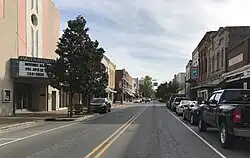
Farmville is a town in Pitt County, North Carolina, United States, eight miles to the west of Greenville. At the 2020 census, the population was 4,461. Farmville is a part of the Greenville Metropolitan Area located in North Carolina's Inner Banks region. Farmville has been a Tree City USA community through the Arbor Day Foundation for 36 years, proving its commitment to managing and expanding its public trees. The Town government, in cooperation with other non-profit groups that work for the advancement of the town, sponsor annual events such as the Farmville Dogwood Festival, the Christmas Parade, Independence Day Celebration, A Taste of Farmville, and the Holiday Open House, among others.
History
Established in February 1872, the town was named Farmville because all of its undertakings and activities were farm related. Among the influential founding fathers of Farmville, James Williams May and William Gray Lang made exceptional contributions to the towns development. Mr. James Williams May was a commissioner named in the original town charter. He donated sites for churches and was a business leader willing to invest his services and resources towards the success of the town. He was the grandson of Major Benjamin May. William Gray Lang served as a commissioner on the town board for more than 10 years. He also serviced on the executive committee appointed to establish the Tobacco Market in Farmville. The town grew slowly, with the 1880 census showing 111 in Farmville and 79 in Marlborough, a nearby unincorporated settlement along the wooden Historic Plank Road. The Marlborough settlement is now inside the town limits of Farmville. The cultivation of Tobacco in Pitt County and the Farmville area began in the 1890s, which helped bring the East Carolina Railway to Farmville in 1900. Most of buildings in downtown Farmville were built shortly after due to the economic boom the railroad helped begin. The Farmville Historic District and Benjamin May-Lewis House are listed on the National Register of Historic Places.[4]
Geography
According to the United States Census Bureau, the town has a total area of 3.1 square miles (8.0 km2), all of it land.
Little Contentnea Creek, a tributary to Contentnea Creek, passes to the north of Farmville.
Demographics
| Census | Pop. | Note | %± |
|---|---|---|---|
| 1880 | 111 | — | |
| 1890 | 140 | 26.1% | |
| 1900 | 262 | 87.1% | |
| 1910 | 816 | 211.5% | |
| 1920 | 1,780 | 118.1% | |
| 1930 | 2,056 | 15.5% | |
| 1940 | 2,980 | 44.9% | |
| 1950 | 2,942 | −1.3% | |
| 1960 | 3,997 | 35.9% | |
| 1970 | 4,424 | 10.7% | |
| 1980 | 4,707 | 6.4% | |
| 1990 | 4,392 | −6.7% | |
| 2000 | 4,302 | −2.0% | |
| 2010 | 4,654 | 8.2% | |
| 2020 | 4,461 | −4.1% | |
| U.S. Decennial Census[5] | |||
2020 census
| Race | Number | Percentage |
|---|---|---|
| White (non-Hispanic) | 2,020 | 45.28% |
| Black or African American (non-Hispanic) | 2,106 | 47.21% |
| Native American | 16 | 0.36% |
| Asian | 13 | 0.29% |
| Other/Mixed | 140 | 3.14% |
| Hispanic or Latino | 166 | 3.72% |
As of the 2020 United States census, there were 4,461 people, 1,813 households, and 1,212 families residing in the town.
Parks and recreation

Parks and recreational facilities include:
- Farmville Municipal Athletic Complex
- JY Monk Park
- RT Monk Memorial Park
- Farmville Disc Golf Course and Walking Trails
- Bennett Park and Playground
- Oliver Murphy Walking Park
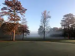
- Farmville Golf and Country Club
Education
Farmville is served by the Pitt County Schools district.[7] Local public schools include:
- H. B. Sugg Elementary School (Previously K through 12) (Now Pre-K – 2nd)
- Sam D. Bundy Elementary School (3rd −5th)
- Farmville Middle School (6th – 8th)
- Farmville Central High School (9th −12th)
- Pitt Community College, Farmville Center-This satellite campus serves as the hub for educational, workforce, and business services in southwest Pitt County, and surrounding counties. Classes are credits are offered to high school and college students, as well as individuals wanting to improve their skills and knowledge in a specific field.
- The Glass Station-Glass Blowing art studio, classroom, and workshop for East Carolina University's School of Art and Design
Notable people
- Sam D. Bundy – Member, North Carolina General Assembly
- Joseph Dixon – United States Congressman (1870–1871)
- Roberta Flack – American singer, taught music in Farmville
- Blenda Gay – Former NFL player, murdered in 1976
- Walter B. Jones Sr. – United States Congressman (1967–1992)
- Walter B. Jones Jr. – United States Congressman (1993–2019)
- Elizabeth Schmoke Randolph (1917–2004), educator
- Terquavion Smith (born 2002) - college basketball player for the NC State Wolfpack
- Mike Sutton – Head Basketball Coach, Tennessee Technological University
- Allen H. Turnage – General, United States Marine Corps
- Edith D. Warren – Member, North Carolina General Assembly
References
- ^ "ArcGIS REST Services Directory". United States Census Bureau. Retrieved September 20, 2022.
- ^ a b U.S. Geological Survey Geographic Names Information System: Farmville, North Carolina
- ^ "U.S. Census website". United States Census Bureau. Retrieved January 31, 2008.
- ^ "National Register Information System". National Register of Historic Places. National Park Service. July 9, 2010.
- ^ "Census of Population and Housing". Census.gov. Retrieved June 4, 2015.
- ^ "Explore Census Data". data.census.gov. Retrieved December 24, 2021.
- ^ "Map of Schools". www.pitt.k12.nc.us. Pitt County Schools. Archived from the original on October 13, 2019. Retrieved March 17, 2019.
External links
Municipalities and communities of Pitt County, North Carolina, United States | ||
|---|---|---|
| City |  | |
| Towns | ||
| Townships |
| |
| CDPs | ||
| Unincorporated communities | ||
| Footnotes | ‡This populated place also has portions in an adjacent county or counties | |