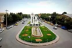
Eqlid
Eqlid
Persian: اقليد | |
|---|---|
City | |
 | |
 Eqlid | |
| Coordinates: 30°53′34″N 52°41′20″E / 30.89278°N 52.68889°E[1] | |
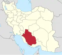
| Country | Iran |
| Province | Fars |
| County | Eqlid |
| District | Central |
| Population (2016)[2] | |
• Total | 44,341 |
| Time zone | UTC+3:30 (IRST) |
| Area code | 0752-422 |
Eqlid (Persian: اقليد,)[a] is a city in the Central District of Eqlid County, Fars province, Iran, serving as capital of both the county and the district.[4]
Historical background
During the Achaemenid empire its name was Azargarta.(source: Parto-e vahid dar asrare takhte jamshid پرتو وحید در اسرار تخت جمشید)
Eqlid's name might come from "kelid," which means key in Persian. Up to the recent years, older people used to call it "kelil." The main reason behind this name is that it was the main gateway to Fars, and specially Persepolis in the old ages and the road called "royal road" used to pass through it. other routes to Persepolis were mountainous and difficult to pass.
Legend says that Eghlid was built by three brothers called Elias, Aslam, and Orjam. There are three main neighborhood (which used to be three castles) in Eghlid bearing the name of these three brothers: Eliasan, Aslaman, Orjaman.
Eqlid has many historical places dating back to pre-Islamic era.
There is an old mosque in the center of the city (jame' mosque)
Etymology
In the local dialect of Eqlid, the city’s name is pronounced as Kilil, a phonetic evolution from the formal Eqlid due to regional sound shifts.
Several theories have been proposed regarding the origin of the name:
1. Greek origin hypothesis: Some linguists suggest that Eqlid derives from the Ancient Greek root kleis or kleid-, meaning “key.” This root appears in many European languages, including French (clé), English (key), and German (Schlüssel). Based on this theory, Eqlid may have been called the “key to Fars” due to its strategic location at a crossroads between northern, central, and southern Iran.
2. Indigenous Iranian origin hypothesis: Other scholars, including Ahmad Tadayyon, argue that Eqlid or Kilil is rooted in Middle Persian or older Iranian languages. Words such as kil, kilil, and klaw historically referred to gateways, passes, or openers. In the local vernacular, kilid still carries the meaning of “gateway” or “access point,” beyond just a tool for opening locks.
3. Mythological–cultural hypothesis: Another theory links the name Kilil to the Mesopotamian goddess Kilili, who was worshipped alongside Ishtar as a deity of love and fertility. After Cyrus the Great conquered Babylon, elements of Babylonian culture, art, and architecture were introduced into the Fars region. It is possible that the name Kilil entered the local lexicon during this period of cultural exchange.
Taken together, these theories suggest that the name Eqlid reflects a rich and layered linguistic and cultural history.
Demographics
Population
At the time of the 2006 National Census, the city's population was 49,709 in 10,214 households.[5] The following census in 2011 counted 44,552 people in 12,435 households.[6] The 2016 census measured the population of the city as 44,341 people in 13,210 households.[2]
مردم این شهر اصالتا از قوم پارس میباشند
Geography
Eqlid is 22 km west of the Expressway between Isfahan and Shiraz. It is close to the mountain chain of Zagros and has one of the highest elevations (a mountain peak known as Bel) among Iran cities (2250 meters).
It is also close to the desert city of Abarqu, making it a city in the border of high mountain and desert. It has a dry and cold weather, and some of its mountain peaks are covered by snow throughout the year. It is an agriculture city and its main products are wheat, barley, potato and fruits like grapes, walnut, apple, and pear. Its main road is Emam Khomeini Boulevard.
Climate
| Climate data for Eqlid (1995-2010 normals) | |||||||||||||
|---|---|---|---|---|---|---|---|---|---|---|---|---|---|
| Month | Jan | Feb | Mar | Apr | May | Jun | Jul | Aug | Sep | Oct | Nov | Dec | Year |
| Daily mean °C (°F) | 1.3 (34.3) |
4.1 (39.4) |
7.8 (46.0) |
12.4 (54.3) |
17.1 (62.8) |
21.3 (70.3) |
23.7 (74.7) |
22.1 (71.8) |
19.2 (66.6) |
14.2 (57.6) |
7.8 (46.0) |
3.9 (39.0) |
12.9 (55.2) |
| Average precipitation mm (inches) | 69.8 (2.75) |
52.0 (2.05) |
65.9 (2.59) |
37.4 (1.47) |
5.9 (0.23) |
1.8 (0.07) |
1.3 (0.05) |
0.3 (0.01) |
0.2 (0.01) |
3.2 (0.13) |
18.0 (0.71) |
59.7 (2.35) |
315.5 (12.42) |
| Source: IRIMO[7][8] | |||||||||||||
Universities and higher education
The following universities and centers are located in Euclid:
- Islamic Azad University[9]
- Payam Noor Uni of Eghlid[10]
- Eghlid University[11]
- Eghlid Higher Education Center[12]
See also
- Aba Saleh al-Mahdi tunnel
- Seyyed Mohammad Bagher Movahed Abtahi
Notes
References
- ^ OpenStreetMap contributors (1 October 2024). "Eqlid, Eqlid County" (Map). OpenStreetMap (in Persian). Retrieved 1 October 2024.
- ^ a b Census of the Islamic Republic of Iran, 1395 (2016): Fars Province. amar.org.ir (Report) (in Persian). The Statistical Center of Iran. Archived from the original (Excel) on 6 April 2022. Retrieved 19 December 2022.
- ^ Eqlid can be found at GEOnet Names Server, at this link, by opening the Advanced Search box, entering "-3062111" in the "Unique Feature Id" form, and clicking on "Search Database".
- ^ Habibi, Hassan (c. 2023) [Approved 12 September 1990]. Approval of the organization and chain of citizenship of the elements and units of the national divisions of Fars province, centered in Shiraz. lamtakam.com (Report) (in Persian). Ministry of the Interior, Council of Ministers. Notification 82840/T128K. Archived from the original on 7 December 2023. Retrieved 7 December 2023 – via Lam ta Kam.
- ^ Census of the Islamic Republic of Iran, 1385 (2006): Fars Province. amar.org.ir (Report) (in Persian). The Statistical Center of Iran. Archived from the original (Excel) on 20 September 2011. Retrieved 25 September 2022.
- ^ Census of the Islamic Republic of Iran, 1390 (2011): Fars Province. irandataportal.syr.edu (Report) (in Persian). The Statistical Center of Iran. Archived from the original (Excel) on 16 January 2023. Retrieved 19 December 2022 – via Iran Data Portal, Syracuse University.
- ^ "AVERAGE OF MEAN DAILY TEMPERATURE IN C. Station: Eqlid(40828)". Chaharmahalmet (asp). Iran Meteorological Organization. Archived from the original on 9 January 2015. Retrieved 21 November 2024.
- ^ "MONTHLY TOTAL OF PRECIPITATION IN MM. Station: Eqlid(40828)". Chaharmahalmet (asp). Iran Meteorological Organization. Archived from the original on 25 February 2017. Retrieved 21 November 2024.
- ^ "Islamic Azad University".
- ^ "Payam Noor Uni of Eghlid".
- ^ "Eghlid University".
- ^ "Eghlid Higher Education Center".
External links
| Capital | |||||||||||||||||||||||||||||||||||
|---|---|---|---|---|---|---|---|---|---|---|---|---|---|---|---|---|---|---|---|---|---|---|---|---|---|---|---|---|---|---|---|---|---|---|---|
| Districts |
| ||||||||||||||||||||||||||||||||||