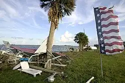
Effects of Hurricane Frances in the Treasure Coast
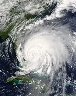 Hurricane Frances making landfall on Hutchinson Island on September 5 | |
| Meteorological history | |
|---|---|
| Formed | August 24, 2004 |
| Extratropical | September 8, 2004 |
| Dissipated | September 10, 2004 |
| Category 2 hurricane | |
| 1-minute sustained (SSHWS/NWS) | |
| Highest winds | 105 mph (165 km/h) |
| Lowest pressure | 960 mbar (hPa); 28.35 inHg |
| Overall effects | |
| Fatalities | 2 |
| Damage | $4.59 billion (2004 USD) |
| Areas affected | Treasure Coast; (Particularly St. Lucie County), Martin County, Indian River County |
| [1] | |
Part of the 2004 Atlantic hurricane season | |
In September 2004, Hurricane Frances severely affected the Treasure Coast in Florida, after making landfall as a Category 2 Hurricane. The impacts of the storm to the area were compounded with the Category 3 landfall of Hurricane Jeanne three weeks later, which made landfall just 2 miles away from the landfall location of Hurricane Frances.[2]
Two fatalities were reported on the Treasure Coast as a result of Frances; one in Martin County, and one in Indian River County.[3] Frances caused an estimated $4.59 billion (2004 USD) in damage across the three Treasure Coast counties, equivalent to $7.8 billion in 2025.[4][1]
Background
Meteorological history
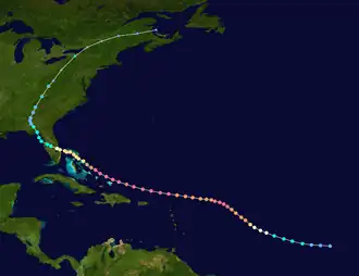
Tropical storm (39–73 mph, 63–118 km/h)
Category 1 (74–95 mph, 119–153 km/h)
Category 2 (96–110 mph, 154–177 km/h)
Category 3 (111–129 mph, 178–208 km/h)
Category 4 (130–156 mph, 209–251 km/h)
Category 5 (≥157 mph, ≥252 km/h)
Unknown
On September 2, Frances entered the Bahamas, passing directly over San Salvador Island and very close to Cat Island. The storm weakened to a Category 3 hurricane by 2 pm, which was initially attributed to inner core processes,[5] but increasing westerly winds aloft, and the resultant vertical wind shear, was later determined to be the cause.[6]
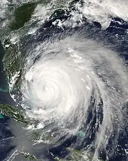
On September 3, Frances passed into the vicinity of Abaco Island and directly over Grand Bahama while continuing to slowly weaken. The storm regained Category 2 hurricane intensity prior to passing over Grand Bahama Island and also slowed in forward speed due to a weakness in the subtropical ridge to its north. Parts of South Florida began to be affected by squalls and the outer rainbands of the hurricane at this time. Gusts from 40 miles per hour (64 km/h) to as high as 87 miles per hour (140 km/h) were reported from Jupiter Inlet to Miami.[6]
Frances moved slowly, between 5 and 10 miles per hour (8.0 and 16.1 km/h), as it crossed the warm Gulf Stream between the Bahamas and Florida, leading to the concern that it could restrengthen. However, Frances remained stable at Category 2 intensity with 105 miles per hour (169 km/h) maximum sustained winds while it battered the east coast of Florida between Fort Pierce and West Palm Beach for much of September 4.
At 11 pm, the western edge of the eyewall began moving onshore in Martin and St. Lucie Counties. Because of its large eye, which was roughly 80 miles (130 km) across, and its slow forward motion, the center of circulation remained offshore for several more hours. At 1 am EDT on September 5 (0500 UTC), the center of the broad eye of Frances made landfall along the Florida coast, at the southern end of Hutchinson Island, or near Sewall's Point.[6]
Preparations
Impact
Below is a summary of the impacts of Hurricane Frances across the Treasure Coast.
| County | Total Damage
(2004 USD) |
Fatalities |
|---|---|---|
| Martin County | $1.020 billion | 1 |
| St. Lucie County | $2.547 billion | 0 |
| Indian River County | $1.023 billion | 1 |
Martin County
Frances moved ashore in South Hutchinson Island, or near Sewall’s Point, in Martin County, causing significant damage. 1,300 residences were damaged or destroyed in Martin County, with 421 homes sustaining major damage, and 846 homes sustaining minor damage.[7]

At the St. Lucie River in Stuart, a water level rise of 5.89 feet occurred as a result of Frances.[8] In Port Salerno, a minimum central pressure of 963 mb and a wind gust to 82 miles per hour (132 km/h) were recorded.[9][10] Total losses in Martin County are at $1.020 billion (2004 USD).[1]
St. Lucie County
In St. Lucie County, Frances caused widespread destruction, destroying 1,129 homes.[11] A wind gust of 111 miles per hour (179 km/h) was measured in Fort Pierce.[12]

The Fort Pierce City Marina was destroyed from Hurricane Frances.[13][10][14] Out of 269 slips present there at the time, the floating docks section, which hosted 138 slips, was destroyed beyond repair.[15] 50+ boats were damaged or destroyed at the marina.[16][17] Damage to the Fort Pierce City Marina exceeded $27.9 million (2004 USD).[15]

A majority of the hangars at the Treasure Coast International Airport were destroyed as well.[10] A bridge carrying State Highway A1A located near the St. Lucie County Nuclear Power Plant was washed away and destroyed on Hutchinson Island.[10]

Total property damage estimates are at $2.5 billion (2004 USD), and damage to the Citrus Industry of St. Lucie County is placed at $46 million (2004 USD).[1]
Indian River County
In Indian River County, wind gusts up to 81 miles per hour (130 km/h) occurred in Vero Beach. More than 3,000 homes and 50% of businesses were damaged from Frances in Indian River County.[3]
Flooding was impactful to the Rock Ridge neighborhood of Vero Beach, particularly between State Road 60 and 17th Street (SR 656).[18] A storm surge of 8 feet was estimated in Vero Beach, resulting in significant flooding and beach erosion on Orchid Island.[19][20] Damage totals in Indian River County are placed at $1.023 billion (2004 USD).[1]
Aftermath
The Treasure Coast is known for its golfing scene.[21] Golf courses suffered heavy damage, particularly to landscaping as a result of Frances. An average of 300-500 trees per golf course were knocked down, which took months to cleanup.[22]

Fort Pierce City Marina reconstruction
After the destruction of the Fort Pierce City Marina from Frances, cleanup took more than one year.[23] The marina was rebuilt and 19 new artificial islands to protect the marina from storm surge were constructed.[24] The project, which costed $18 million (2013 USD), was completed in 2013.[23]
See also
- Hurricane Jeanne
- 2004 Atlantic Hurricane Season
- Hurricane Nicole (2022) A Category 1 hurricane in 2022 that also made landfall in the Treasure Coast
- Hurricane Erin (1995) A Category 2 hurricane in 1995 that made landfall in the Treasure Coast
- Hurricane David A hurricane in 1979 that made landfall in a similar location as a category 2 hurricane
References
- ^ a b c d e "Storm Events Database - Search Results | National Centers for Environmental Information". www.ncdc.noaa.gov. Retrieved 2025-07-29.
- ^ News, Chris Bonanno For Hometown (2024-08-28). "Looking back on Frances and Jeanne 20 years later". Hometown News Treasure Coast. Retrieved 2025-07-29.
{{cite web}}:|last=has generic name (help) - ^ a b "Article clipped from News-Press". News-Press. 2004-09-19. p. 8. Retrieved 2025-07-29.
- ^ "$4,590,000,000 in 2004 → 2025 | Inflation Calculator". www.in2013dollars.com. Retrieved 2025-07-29.
- ^ Lixion A. Avila (September 2, 2004). "Hurricane Frances Discussion Number 36". National Hurricane Center. Retrieved July 18, 2024.
- ^ a b c Cite error: The named reference
TCRwas invoked but never defined (see the help page). - ^ "Article clipped from The Stuart News". The Stuart News. 2004-09-17. p. 13. Retrieved 2025-07-29.
- ^ Greenlee, Will. "20 years ago, Hurricane Frances brought widespread damage to Treasure Coast". Treasure Coast. Retrieved 2025-07-29.
- ^ "Hurricane FRANCES". www.nhc.noaa.gov. Retrieved 2025-07-29.
- ^ a b c d "NOAA" (PDF). Hurricane Frances Tropical Cyclone Report. Retrieved 2025-07-29.
- ^ "Article clipped from The Palm Beach Post". The Palm Beach Post. 2004-09-25. p. 6. Retrieved 2025-07-29.
- ^ News, Chris Bonanno For Hometown (2023-09-27). "A look back at a wild 2004 hurricane season". Hometown News Treasure Coast. Retrieved 2025-07-29.
{{cite web}}:|last=has generic name (help) - ^ "FORT PIERCE MARINA TELLS A STORY OF HURRICANE FURY - Bellingham Marine". bellingham-marine.com. 2005-05-15. Retrieved 2025-07-29.
- ^ "The City of Fort Pierce marina was destroyed when Hurricanes Francis and Jeanne moved through #Florida's Central East Coast in 2004. | Tetra Tech". www.linkedin.com. Retrieved 2025-07-29.
- ^ a b "CITY OF FT. PIERCE MARINA". Maccaferri USA. Retrieved 2025-07-29.
- ^ "One-two hurricane punch". soundingsonline.com. 2005-06-02. Retrieved 2025-07-29.
- ^ "Gallery: A look back at Hurricanes Frances and Jeanne 15 years later". Florida Today. Retrieved 2025-07-29.
- ^ "Frances - Vero Beach". www.cbsnews.com. 2004-09-06. Retrieved 2025-07-29.
- ^ "Hurricanes: Science and Society: 2004- Hurricane Frances". hurricanescience.org. Retrieved 2025-07-29.
- ^ "Hurricane Frances (2004) | Florida Tech". research.fit.edu. Retrieved 2025-07-29.
- ^ Westlund, Richard. "Treasure Coast has distinctive golf clubs". Treasure Coast. Retrieved 2025-07-30.
- ^ "The Impact Of The 2004 Hurricane Season On Florida Golf Courses | United States Golf Association". www.usga.org. Archived from the original on 2008-12-04. Retrieved 2025-07-30.
- ^ a b "Treasure Coast Subscription Offers, Specials, and Discounts". subscribe.tcpalm.com. Retrieved 2025-07-30.
- ^ "FORT PIERCE CITY MARINA - Bellingham Marine". bellingham-marine.com. Retrieved 2025-07-30.