Efate
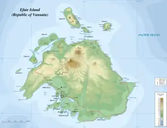 Map of Efate | |
 | |
| Geography | |
|---|---|
| Location | Pacific Ocean |
| Coordinates | 17°40′S 168°25′E / 17.667°S 168.417°E |
| Archipelago | Vanuatu |
| Area | 899.5 km2 (347.3 sq mi) |
| Highest elevation | 647 m (2123 ft) |
| Highest point | Mount McDonald |
| Administration | |
Vanuatu | |
| Province | Shefa Province |
| Largest settlement | Port Vila |
| Demographics | |
| Population | 66,000 (2010) |
| Pop. density | 55.6/km2 (144/sq mi) |
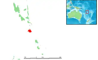
Efate (French: Éfaté), originally named Sandwich Island and also known as Île Vate (French: [il vat]) or just Vate, is an island in the Pacific Ocean. It is part of the Shefa Province in Vanuatu, and the capital city, Port Vila, is located on the island.
History
Captain James Cook named the island Sandwich Island in honour of his patron, the Earl of Sandwich, on his 1774 voyage on HMS Resolution.[1]
The island was referred to by its French name, Île Vate,[2] or simply Vate, in newspaper reports in 1950 and 1951, when it was visited by the Royal Navy vessel HMS Havannah[3][4]
Coconut trees were planted on large plantations by European settlers in the islands in the late 1800s, owing to the growing demand for copra, the dried flesh of the coconut that contains the oil. The first of these coconut plantations was on Efate, planted in 1877.[5]
During the 19th century, Australian, British, French, and German settlers settled in the territory of the New Hebrides.[6] In 1878, the United Kingdom and France declared all of the New Hebrides to be neutral territory.[7] In 1887, the Anglo-French Joint Naval Commission took charge of the territory. On 9 August 1889, Franceville, an area around present-day Port Vila, declared itself an independent commune under the leadership of elected mayor/president Ferdinand-Albert Chevillard,[8][9][10] and with its own red, white and blue flag with five stars.[11][12] It became one of the first self-governing nations in recorded history to practice universal suffrage without distinction of sex or race.[13] However, the new government was soon suppressed, and by June 1890, Franceville as a commune was reported to have been "practically broken up", with the Naval Commission resuming control.[14]
Between 1903 and 1905, one of the first major geological works of Melanesia was produced by Australian geologist Sir Douglas Mawson (later renowned for his expeditions to Antarctica).[15] After spending from April to September 1903 exploring the islands with W.T. Quaife, Mawson produced a report which included geological maps of the islands of Efate and Santo. This was his first major independent geological work.[16] The men travelled to the islands aboard the Ysabel, under the auspices of the British Deputy Commissioner of the New Hebrides, Captain Ernest Rason.[a] HMS Archer was also used on the trip.[16] Mawson's detailed report, "The Geology of the New Hebrides", was published in the Proceedings of the Linnean Society of New South Wales in December 1905.[19]
In 1906, the naval commission was replaced by a more structured British-French Condominium.[6]
During World War II, Efate served an important role as a United States military base.[20]
On 13 March 2015, Port Vila, the island's largest human settlement and the capital of Vanuatu, bore extensive damage from Cyclone Pam.[21] In December 2024, a magnitude 7.3 earthquake reportedly damaged almost every single house on Efate, resulting in 19 fatalities.[22] The United Nations Office for the Coordination of Humanitarian Affairs estimated that 116,000 people had been directly affected by the earthquake,[23] equivalent to a third of Vanuatu's population.[24]
Geography

Efate's land area of 899.5 square kilometres (347.3 sq mi) makes it Vanuatu's third largest island.[25]
Its geological past was heavily volcanic, meaning that a lava shelf surrounds much of the island. Its highest mountain is Mount Macdonald, with a height of 647 metres (2,123 ft).[26][27][28] The terrain is rugged.[25]
Efate's climate is warm and humid, and the island mostly covered by tropical rainforest.[25]
Port Vila is the capital city, and lies on the southwest coast in Shefa Province.[29][25] Its harbour is Mélé Bay.[25] Pango is a community located on the southern coast of Efate, 7 km (4.3 mi) away from Port Vila, and is considered peri-urban.[30]
On the other side of the island, on the northwest coast, is the village of Port Havannah.[25]
Small islands off Efate
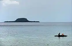
Around Efate lie many small islands, among them are Eretoka (Hat) Island, Lelepa, Nguna, Pele, Ekapum Lep, Erueti Lep, Ekapum Rik, Iriwiti Lep, Hideaway Island, Ifira Island, and Emao.
Eretoka Island is a small island that, when seen from a distance looks like a floppy hat. This is where the famous Chief Roi Mata, along with his 20 wives and many other servants, were buried.[31] Nguna, Pele and Emao are stratovolcanoes, which may form the rim of a volcanic caldera to their north.[32]
Demographics
Efate is the most populous island in Vanuatu, with 50,340 persons, representing 17 per cent of the national population, as recorded in the 2020 census.[33] Most inhabitants of Efate live in Port Vila, the national capital.[29]
There are roughly half a dozen languages spoken on Efate, including Central Vanuatu languages such as Nakanamanga (Nguna, North Efate), Namakura (Makura, Namakir), Nafsan (Erakor, South Efate), Lelepa (Havannah Harbour), and Eton, as well as the Polynesian outlier language Mele-Fila. The North Efate and South Efate languages are not very closely related, and when missionaries became active on the island, they encouraged the use of a zonal auxiliary language, Efatese, based on various languages of Efate.[34]
Governance
Efate is governed by both the Port Vila Municipality and the Shefa Provincial Council, whose governance is the town limits of Port Vila only, and rural Efate and the outer Efate Islands, respectively.
The island outside of Port Vila is represented in Parliament by the five-seat riding of Efate. Port Vila has its own five-seat riding. These ten MPs are elected through Single non-transferable voting.
Economy and tourism
The economy of Vanuatu is largely dependent on subsistence agriculture and tourism. Since the 2010s, planting of coconut plantations and the production of coconut products has increased, after falling into neglect in the 1980s.[5]
The capital of Port Vila is the hub of tourism in Vanuatu, receiving tourists by air, cruise ships, and the yachts. Due to the British and French influence, both cuisines are readily available in the capital. There are also Chinese eateries across Vila and the Mummas Market downtown. Outside of Port Vila, most people live a traditional lifestyle, cooking island food or aelan kakae, and swimming at the beach.
The Mele Cascades and the quieter Lololima Falls and rock pools are popular recreation areas for tourists.[35][36][37] Other attractions include Eton Beach and the Tanalilui Road Markets.
Port Vila services the domestic carrier Air Vanuatu which goes to the outer islands of Vanuatu. Popular destinations such as Tanna and Santo can be reached daily from Port Vila, while more remote locations can be reached on a less regular basis. The island is served by Bauerfield International Airport.
In popular culture
Efate was used as the location for three seasons of the reality game show, Survivor. The island was used for season 9 of the American edition of Survivor (titled Survivor: Vanuatu - Islands of Fire), season 2 of Australian Survivor (titled Australian Celebrity Survivor: Vanuatu) and season 6 of the French edition (titled Koh-Lanta: Vanuatu).
Much of the Survivor: Vanuatu and Australian Celebrity Survivor was filmed approximately 30 minutes from Port Vila near Mangililu and Gideon's Landing, the latter of which is now a commonly visited tourist attraction.
Footnotes
References
- ^ "JULY – SEPTEMBER 1774". Captain Cook Society. Retrieved 14 December 2016.
- ^ "Vanuatu, Efate, Ile Vate Port-Vila, 1:12 500" (library catalogue entry for a map). 8 August 2017. Retrieved 3 August 2025.
- ^ "SHIPPING NEWS". The Courier (Hobart). Vol. XXIII, no. 1634. Tasmania, Australia. 7 December 1850. p. 2. Retrieved 3 August 2025 – via National Library of Australia.
- ^ "NEW ZEALAND". The Shipping Gazette and Sydney General Trade List. Vol. VIII, no. 381. New South Wales, Australia. 12 July 1851. p. 199. Retrieved 3 August 2025 – via National Library of Australia.
- ^ a b Department of Agriculture and Rural Development, Vanuatu. "Vanuatu national coconut strategy 2016-2025" (PDF). Retrieved 31 July 2025.
- ^ a b Bresnihan, Brian J.; Woodward, Keith (2002). Tufala Gavman: Reminiscences from the Anglo-French Condominium of the New Hebrides. editorips@usp.ac.fj. p. 422. ISBN 978-982-02-0342-6. Retrieved 31 July 2025.
- ^ "Arrangement between Great Britain and France, respecting the Independence of the New Hebrides Group" (PDF). January–February 1878. Archived from the original (PDF) on 29 February 2012. Retrieved 22 January 2010.
- ^ Pelatan, Louis (1889). Lettres calédoniennes. Impr. du Colon. p. 73.
- ^ Sydney Morning Herald, Aug 26, 1889
- ^ "The 'Commune' of Franceville," North Otago Times (New Zealand), Sep 5, 1889
- ^ Imhaus, E.N. (1890). Les Nouvelles-Hébrides: avec une carte et sept gravures. pp. 154–160.
- ^ Simpson, Colin (1955), Islands of Men: A Six-part Book about Life in Melanesia, p 133
- ^ "Wee, Small Republics: A Few Examples of Popular Government," Hawaiian Gazette, Nov 1, 1895, p 1
- ^ "Latest Cable News: Australian News," The West Coast Times (New Zealand), June 28, 1890, p 2
- ^ "A synopsis of Mawson's life". Douglas Mawson. South Australian Museum. Retrieved 31 July 2025.
- ^ a b J. B. Jago; M. D. Pharaoh; C. L. Wilson-Roberts (1 April 2005). "Douglas Mawson's First Major Geological Expedition: The New Hebrides, 1903". Earth Sciences History. 24 (1): 93–111. Bibcode:2005ESHis..24...93J. doi:10.17704/eshi.24.1.f771465730u1w938.
- ^ Thieberger, N. & Ballard, C. (2008). "Daniel Macdonald and the 'compromise literary dialect' in Efate, central Vanuatu". Oceanic Linguistics, 47 (2), pp.373. doi:10.1353/ol.0.0015. Retrieved 30 July 2025
- ^ "British District Commissioners Residency". British Museum. Collections Online. Retrieved 30 July 2025.
- ^ Mawson, Douglas (20 December 1905). "The geology of the New Hebrides". Proceedings of the Linnean Society of New South Wales. 30: 400–485. Bibcode:1905PLSNS..30..400M. doi:10.5962/bhl.part.12911. ISSN 0370-047X. Retrieved 27 June 2025 – via Smithsonian Institution.
- ^ Fighter Squadron at Guadalcanal, Max Brand, Naval Institute Press, 1996, ISBN 1-55750-088-6
- ^ Andrew Freedman (13 March 2015). "Monstrous Category 5 cyclone makes direct hit on tiny Vanuatu". Mashable. Retrieved 4 April 2015.
- ^ "Live: Rescue efforts continue in Vanuatu, international assistance begins to arrive". Radio New Zealand. 18 December 2024. Retrieved 18 December 2024.
- ^ "Buildings 'pancaked' in Vanuatu as 7.4 magnitude earthquake rocks Pacific nation". South China Morning Post. 17 December 2024. Retrieved 17 December 2024.
- ^ "Vanuatu earthquake death toll rises to 14 as rescuers search for survivors". Al Jazeera. 18 December 2024. Retrieved 18 December 2024.
- ^ a b c d e f Murray, Lorraine (15 October 2008). "Efate". Encyclopedia Britannica. Retrieved 1 August 2025.
- ^ Thieberger, Nicholas (31 July 2006). A Grammar of South Efate: An Oceanic Language of Vanuatu. University of Hawaii Press. ISBN 978-0-8248-3061-8. Retrieved 1 August 2025.
- ^ United States. Hydrographic Office (1916). Pacific Islands Pilot, Volume 1. U.S. Government Printing Office. Retrieved 1 August 2025.
- ^ Speiser, Felix (1999). Ethnology of Vanuatu. C. Hurst, Publishers, Limited. ISBN 978-1-85065-508-4. Retrieved 1 August 2025.
- ^ a b Hakkert, Ralph; Pontifex, Scott (October 2022). "Vanuatu 2020 National Population and Housing Census – Analytical Report: Volume 2" (PDF). Noumea, New Caledonia: Vanuatu Bureau of Statistics and the Pacific Community. Retrieved 31 July 2025.
- ^ Rawlings, Gregory E. (September 1999). "Foundations of Urbanisation: Port Vila Town and Pango Village, Vanuatu". Oceania. 70 (1). The University of Sydney: 72–86. doi:10.1002/j.1834-4461.1999.tb02990.x. Retrieved 18 December 2024.
- ^ J. Maarten Troost, Getting Stoned with Savages, Broadway Books, 2006 (ISBN 0-7679-2199-2).
- ^ "North Vate". Global Volcanism Program. Smithsonian Institution. Retrieved 21 March 2020.
- ^ "Efate Rural Constituency". Vanuatu Bureau of Statistics. 24 June 2024. Retrieved 31 July 2025.
- ^ *Robert Henry Codrington (1885) "Fate, Sandwich Islands", in The Melanesian Languages, 471–476. Oxford: Clarendon Press. *Daniel MacDonald (1889) "Grammar of the Efatese language", in Daniel MacDonald (ed.), Three New Hebrides Languages (Efatese, Eromangan, Santo), 1–58. Melbourne: Edgerton and Moore.
- ^ "Take the Plunge at Vanuatu's Must-see Waterfalls". Vanuatu Tourism Office. Retrieved 31 July 2025.
- ^ "River and Waterfall Lololima". vanuatu-ecotour.com.vu. 26 October 2011. Archived from the original on 27 November 2016. Retrieved 31 July 2025.
- ^ "Lololima waterfalls". Mindtrip. Retrieved 31 July 2025.
External links
- Languages of Efate Bibliography of the island's indigenous languages.
- Paradisec's open access collections includes collections by Arthur Capell and Nicholas Thieberger about Efate