Drahoňův Újezd
Drahoňův Újezd | |
|---|---|
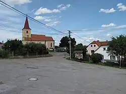 Church of Saint James the Great | |
 Flag  Coat of arms | |
 Drahoňův Újezd Location in the Czech Republic | |
| Coordinates: 49°52′38″N 13°43′33″E / 49.87722°N 13.72583°E | |
| Country | |
| Region | Plzeň |
| District | Rokycany |
| First mentioned | 1352 |
| Area | |
• Total | 13.99 km2 (5.40 sq mi) |
| Elevation | 410 m (1,350 ft) |
| Population (2025-01-01)[1] | |
• Total | 134 |
| • Density | 9.6/km2 (25/sq mi) |
| Time zone | UTC+1 (CET) |
| • Summer (DST) | UTC+2 (CEST) |
| Postal code | 338 08 |
| Website | www |
Drahoňův Újezd is a municipality and village in Rokycany District in the Plzeň Region of the Czech Republic. It has about 100 inhabitants.
Drahoňův Újezd lies approximately 16 kilometres (10 mi) north-east of Rokycany, 28 km (17 mi) north-east of Plzeň, and 57 km (35 mi) south-west of Prague.
History
From 1 April 1980 to 31 December 1992, Drahoňův Újezd was a municipal part of Zbiroh.[2]
Demographics
| Year | Pop. | ±% |
|---|---|---|
| 1869 | 335 | — |
| 1880 | 308 | −8.1% |
| 1890 | 285 | −7.5% |
| 1900 | 268 | −6.0% |
| 1910 | 266 | −0.7% |
| 1921 | 237 | −10.9% |
| 1930 | 260 | +9.7% |
| 1950 | 210 | −19.2% |
| 1961 | 199 | −5.2% |
| 1970 | 165 | −17.1% |
| 1980 | 162 | −1.8% |
| 1991 | 130 | −19.8% |
| 2001 | 144 | +10.8% |
| 2011 | 125 | −13.2% |
| 2021 | 131 | +4.8% |
| Source: Censuses[3][4] | ||
References
- ^ "Population of Municipalities – 1 January 2025". Czech Statistical Office. 2025-05-16.
- ^ "Historický lexikon obcí České republiky 1869–2011: Abecední přehled obcí a částí obcí" (PDF) (in Czech). Czech Statistical Office. 2015-12-21. p. 107.
- ^ "Historický lexikon obcí České republiky 1869–2011" (in Czech). Czech Statistical Office. 2015-12-21.
- ^ "Population Census 2021: Population by sex". Public Database. Czech Statistical Office. 2021-03-27.
External links
Wikimedia Commons has media related to Drahoňův Újezd.