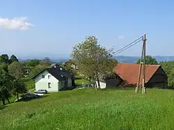
Dolgo Brdo, Litija
Dolgo Brdo | |
|---|---|
 | |
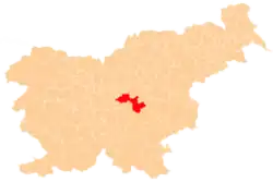
 Dolgo Brdo Location in Slovenia | |
| Coordinates: 46°2′56.77″N 14°55′38.54″E / 46.0491028°N 14.9273722°E | |
| Country | |
| Traditional region | Lower Carniola |
| Statistical region | Central Sava |
| Municipality | Litija |
| Area | |
• Total | 2.44 km2 (0.94 sq mi) |
| Elevation | 753.3 m (2,471.5 ft) |
| Population (2002) | |
• Total | 27 |
| [1] | |
Dolgo Brdo (pronounced [ˈdoːu̯ɡɔ ˈbəɾdɔ]; German: Langeneck)[2] is a small settlement in the Municipality of Litija in central Slovenia. The area is part of the traditional region of Lower Carniola. It is now included with the rest of the municipality in the Central Sava Statistical Region; until January 2014 the municipality was part of the Central Slovenia Statistical Region.[3]
Geography
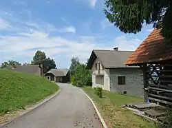
Dolgo Brdo is a scattered settlement in the southern part of the Polšnik Hills (Slovene: Polšniški hribi). Izerca Hill (elevation: 801 meters or 2,628 feet) rises above the settlement, and Žrjavec Hill (a.k.a. Čerjavec Hill; elevation: 854 meters or 2,802 feet) stands to the east. Dolgo Brdo includes the hamlet of Prelesje northwest of the center of the village.[4]
References
- ^ Statistical Office of the Republic of Slovenia
- ^ Leksikon občin kraljestev in dežel zastopanih v državnem zboru, vol. 6: Kranjsko. Vienna: C. Kr. Dvorna in Državna Tiskarna. 1906. p. 94.
- ^ Municipality of Litija website
- ^ Savnik, Roman (1971). Krajevni leksikon Slovenije, vol. 2. Ljubljana: Državna založba Slovenije. p. 260.
External links
 Media related to Dolgo Brdo at Wikimedia Commons
- Dolgo Brdo on Geopedia