Island of Danna
| Scottish Gaelic name | Danna |
|---|---|
| Pronunciation | [ˈt̪an̪ˠə] ⓘ |
| Meaning of name | Danes' island (from Old Norse Danaey)[1] |
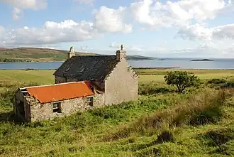 An empty farmhouse on Danna | |
| Location | |
 Island of Danna Island of Danna shown within Argyll and Bute | |
| OS grid reference | NR695785 |
| Coordinates | 55°56′N 5°41′W / 55.94°N 5.69°W |
| Physical geography | |
| Island group | Islay |
| Area | 315 ha (1+1⁄4 sq mi) |
| Area rank | 83 [2] |
| Highest elevation | 54 m (177 ft) |
| Administration | |
| Council area | Argyll and Bute |
| Country | Scotland |
| Sovereign state | United Kingdom |
| Demographics | |
| Population | 5[3] |
| Population rank | 80= [2] |
| Population density | 1.6/km2 (4.1/sq mi)[3][4] |
| References | [4][5] |
Danna (Scottish Gaelic: Danna) is an inhabited tidal island in Argyll and Bute.
Geography
It is connected to the mainland by a stone causeway and is at the southern end of the narrow Tayvallich peninsula, which separates Loch Sween from the Sound of Jura.[6] It is part of the Ulva, Danna and the MacCormaig Isles SSSI.[7] Danna is part of the Knapdale National Scenic Area, one of 40 in Scotland.[8]
Footnotes
- ^ Morgan, Ailig Peadar (2013). Ethnonyms in the Place-Names of Scotland and the Border Counties of England (PhD thesis). St Andrews University. p. 132.
- ^ a b Area and population ranks: there are c. 300 islands over 20 ha in extent. 93 permanently inhabited islands were listed in the 2011 census and 101 such islands in 2022.
- ^ a b "Scottish Islands Data Dashboard". RESAS/Scottish Government. 2025. p. 6. Retrieved 1 June 2025.
- ^ a b Haswell-Smith, Hamish (2004). The Scottish Islands. Edinburgh: Canongate. ISBN 978-1-84195-454-7.
- ^ Ordnance Survey: Landranger map sheet 61 Jura & Colonsay (Map). Ordnance Survey. 2013. ISBN 9780319229620.
- ^ Murray, W.H. (1977) The Companion Guide to the West Highlands of Scotland. London. Collins. Page 89.
- ^ SSSI Designation Archived 28 September 2007 at the Wayback Machine. The nearby Ulva Islands should not be confused with Ulva near Mull.
- ^ "National Scenic Areas". SNH. Retrieved 30 Mar 2011.
Wikimedia Commons has media related to Island of Danna.
|  | ||||||||||||||||
|
| |||||||||||||||||
| |||||||||||||||||
| |||||||||||||||||
| |||||||||||||||||
| |||||||||||||||||
| |||||||||||||||||
| |||||||||||||||||
55°56′41″N 5°41′27″W / 55.94472°N 5.69083°W