Cooloola, Queensland
| Cooloola Queensland | |||||||||||||||
|---|---|---|---|---|---|---|---|---|---|---|---|---|---|---|---|
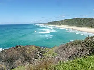 Double Island Point, Cooloola, 2016 | |||||||||||||||
 Cooloola | |||||||||||||||
| Coordinates | 26°02′00″S 153°03′50″E / 26.0333°S 153.0638°E | ||||||||||||||
| Population | 0 (2021 census)[1] | ||||||||||||||
| • Density | 0.0000/km2 (0.0000/sq mi) | ||||||||||||||
| Postcode(s) | 4580 | ||||||||||||||
| Elevation | 4 m (13 ft) | ||||||||||||||
| Area | 474.5 km2 (183.2 sq mi) | ||||||||||||||
| Time zone | AEST (UTC+10:00) | ||||||||||||||
| Location |
| ||||||||||||||
| LGA(s) | Gympie Region | ||||||||||||||
| State electorate(s) | Gympie | ||||||||||||||
| Federal division(s) | Wide Bay | ||||||||||||||
| |||||||||||||||
Cooloola is a coastal locality in the Gympie Region, Queensland, Australia.[2] In the 2021 census, Cooloola had "no people or a very low population".[1]
Geography
Cooloola is a coastal locality, being bounded by Wide Bay in the Coral Sea to the east including the major headland, Double Island Point. From Double Island Point, Rainbow Beach extends to the west and then to the north, while Teewah Beach stretches for many kilometres to the south. The locality's north-west boundary is Tin Can Inlet off Tin Can Bay.[3]
Off the coast of Double Island Point is Wolf Rock which is Queensland's most important habitat area for the critically endangered grey nurse shark. It is a mating area and a high number of females and pregnant females have been seen there.[4]
The entire locality is a protected area, mostly within the Great Sandy National Park except for a small area on Double Island Point which is within the Double Island Point Conservation Park.[3] Consistent with its protected status, the land use is nature conservation with very limited development apart from some basic bushwalking and camping infrastructure with a number of strict rules about its use.[5][6]
History
In 1865, William Pettigrew discovered the timber resources of the Cooloola area and established a sawmill and a tramway to harvest the timber. Timber cutting continued in the area until the 1960s when proposals to introduce sand mining and other kinds of development of the area resulted in protests about the environmental damage that it would cause. In 1975, the area was gazetted as the Cooloola National Park (later renamed the Great Sandy National Park).[7]
Demographics
In the 2011 census, Cooloola had "no people or a very low population".[8]
In the 2016 census, Cooloola had a population of 3 people.[9]
In the 2021 census, Cooloola had "no people or a very low population".[1]
Heritage listings
.jpg)
Cooloola has a number of heritage-listed sites, including:
- Cooloola Tramway (25°59′37″S 153°04′35″E / 25.9936°S 153.0763°E)[7]
- Double Island Point Light (25°55′55″S 153°11′14″E / 25.93199°S 153.18714°E)[10]
Attractions
The Cooloola Great Walk is a 5-day walking track through Cooloola through to Rainbow Beach (to the north) and Noosa North Shore to the south.[11][12][13]
Education
There are no schools in Cooloola. The nearest government primary schools are Rainbow Beach State School in neighbouring Rainbow Beach to the north-east and Tin Can Bay State School in neighbouring Tin Can Bay to the north-west. The nearest government secondary school is Tin Can Bay State School (to Year 10). There are no nearby secondary schools providing education to Year 12; the alternatives are distance education and boarding school.[14]
See also
References
- ^ a b c Australian Bureau of Statistics (28 June 2022). "Cooloola (SAL)". 2021 Census QuickStats. Retrieved 28 February 2023.
- ^ "Cooloola – locality (entry 47613)". Queensland Place Names. Queensland Government. Retrieved 31 October 2015.
- ^ a b "Queensland Globe". State of Queensland. Retrieved 1 September 2023.
- ^ "Grey nurse shark". www.ehp.qld.gov.au. Queensland Government. Archived from the original on 29 October 2015. Retrieved 31 October 2015.
- ^ "Layers: Locality; Protected areas and forests; Land use". Queensland Globe. Queensland Government. Retrieved 24 July 2025.
- ^ "About | Cooloola Recreation Area, Great Sandy National Park". Parks and forests. Queensland Government. Retrieved 24 July 2025.
- ^ a b "Pettigrew's Cooloola Timber Tramway Complex (entry 602819)". Queensland Heritage Register. Queensland Heritage Council. Retrieved 1 August 2014.
- ^ Australian Bureau of Statistics (31 October 2012). "Cooloola". 2011 Census QuickStats. Retrieved 31 October 2015.
- ^ Australian Bureau of Statistics (27 June 2017). "Cooloola (SSC)". 2016 Census QuickStats. Retrieved 20 October 2018.
- ^ "Double Island Point Lightstation (entry 601722)". Queensland Heritage Register. Queensland Heritage Council. Retrieved 8 July 2013.
- ^ "Cooloola Great Walk". www.nprsr.qld.gov.au. Queensland Government. Archived from the original on 20 December 2015. Retrieved 31 October 2015.
- ^ "Cooloola Great Walk". Parks and forests. Queensland Government. 12 March 2010. Archived from the original on 30 June 2023. Retrieved 31 August 2023.
- ^ "About | Cooloola Great Walk". Parks and forests. Queensland Government. 12 March 2010. Archived from the original on 7 June 2023. Retrieved 31 August 2023.
- ^ "Layers: Locality; Schools and school catchments". Queensland Globe. Queensland Government. Retrieved 24 July 2025.