Comical Corner, New Jersey
Comical Corner, New Jersey | |
|---|---|
 | |
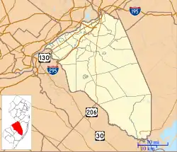 Comical Corner Location of Comical Corner in Burlington County (Inset: Location of county within the state of New Jersey)  Comical Corner Comical Corner (New Jersey)  Comical Corner Comical Corner (the United States) | |
| Coordinates: 39°59′00″N 74°41′00″W / 39.98333°N 74.68333°W | |
| Country | |
| State | |
| County | Burlington |
| Township | Pemberton |
| Elevation | 69 ft (21 m) |
| Time zone | UTC−05:00 (Eastern (EST)) |
| • Summer (DST) | UTC−04:00 (EDT) |
| GNIS feature ID | 875595[1] |
Comical Corner or Comical Corners is an unincorporated community located within Pemberton Township in Burlington County, in the U.S. state of New Jersey.[2][3][4] The site of the actual corners is at the intersection of Pemberton Road (County Route 630) and Arneys Mount Road (CR 668). The original name may have been "Conical Corner" based on the cone-like shape of the skewed intersection but had turned to "Comical Corner" based on a mishearing.[5]
While most historical maps of the area do support this hypothesis as to the origin of the community's name, such as a county map as early as 1849[6], one of the earliest maps of Burlington County does not. A map covering a portion of the county prepared in 1840 identifies the corner as Commical [sic] Corner just north of Pemberton, but the community, displayed as 4 houses at that time, was not an intersection but simply a bend in the road.[7] The roads present on the 1840 map are today's North Pemberton Road heading west and Pemberton Arneys Mt Road heading south[8]. This map only covers a portion of the county and it is possible the community was a true intersection in 1840, but other roads that extend off the map coverage area are drawn as such. This map presents an alternate possibility that it may have been "comical" because the "corner" was not an actual corner but just a kink in the road.
The area, located just to the north of Pemberton Borough, is mostly rural and is surrounded by farmland on the two obtuse sides of the intersection.[9]
References
- ^ a b "Comical Corners". Geographic Names Information System. United States Geological Survey, United States Department of the Interior.
- ^ Gannett, Henry (January 28, 1895). "A Geographic Dictionary of New Jersey". U.S. Government Printing Office – via Google Books.
- ^ "NJDOT Graphic Information System Maps Burlington" (PDF). New Jersey Department of Transportation. Retrieved March 27, 2020.
- ^ Locality Search, State of New Jersey. Accessed March 14, 2015.
- ^ Quigley, Patricia (February 22, 1987). "What's In A Name? It Can Be A Key To An Origin Lost In The Mists Of Time". The Philadelphia Inquirer. Archived from the original on October 18, 2015. Retrieved June 21, 2016.
According to [Rhett Pernot, administrator of the Burlington County Historical Society], Comical Corners may have derived its name from 'conical corner,' referring to the cone shape of the junction. 'It doesn't appear on any map as Conical Corners . . . so the origins of that name are obscure at best,' said Pernot.
- ^ Otley, J. W.; Whiteford, R.; Kramm, Gustavus; Worley, Geo (January 1, 1849), Map of Burlington County, Smith & Wistar, Philadelphia: Published by Smith & Wistar, retrieved August 14, 2025
- ^ General-content map of several townships in the southern part of Burlington County, N.J., 184-?, January 1, 1840, retrieved August 14, 2025
{{citation}}: CS1 maint: location (link) - ^ "39°59'00.5"N 74°41'01.3"W · 39.983472, -74.683694". 39°59'00.5"N 74°41'01.3"W · 39.983472, -74.683694. Retrieved August 14, 2025.
- ^ "Aerial view of Comical Corners" (Map). Google Maps. Retrieved June 21, 2016.
