Col du Noyer
| Col du Noyer | |
|---|---|
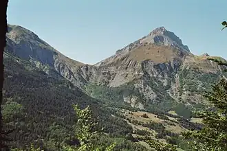
 Col du Noyer, seen from Champsaur. | |
| Elevation | 1,664 m (5,459 ft) |
| Traversed by | D 17 |
| Location | Hautes-Alpes, France |
| Range | Alps |
| Coordinates | 44°41′31″N 5°59′7″E / 44.69194°N 5.98528°E |
Col du Noyer (el. 1664 m.) is a high mountain pass in the Alps in the department of Hautes-Alpes in France.
Details of the climb
From Le Noyer, the climb is 7.5 km, with an elevation gain of 616 m, an average gradient of 8.2%, and maximum gradient of 14.5%.[1]
From Saint-Disdier, the climb is 14.5 km, with an elevation gain of 616 m, an average gradient of 4.3%, and maximum gradient of 7.5%.[2]
Appearances in Tour de France
The pass was first included in the Tour de France in 1970 and has since featured 5 times, most recently in 2024.[3]
| Year | Stage | Category | Start | Finish | Leader at the summit |
|---|---|---|---|---|---|
| 2024 | 17 | 1 | Saint-Paul-Trois-Châteaux | SuperDévoluy | |
| 2010 | 10 | 2 | Chambéry | Gap | |
| 1982 | 15 | 2 | Manosque | Orcières-Merlette | |
| 1971 | 11 | 2 | Grenoble | Orcières-Merlette | |
| 1970 | 13 | 1 | Grenoble | Gap |
See also
- Cycling Col du Noyer - Maps, Profiles, Photos
- List of highest paved roads in Europe
- List of mountain passes
References
- ^ "Col du Noyer from Le Noyer : 1664m". Cols-cyclisme. Retrieved 2025-08-02.
- ^ "Col du Noyer from Saint Disdier : 1664m". Cols-cyclisme. Retrieved 2025-08-02.
- ^ "Le col du Noyer dans le Tour de France". ledicodutour.com. Retrieved 17 July 2024.