Col de la Ramaz
| Col de la Ramaz | |
|---|---|
 Highest point of the road, 60 meters above the pass itself | |
| Elevation | 1,559 m (5,115 ft) |
| Location | Haute-Savoie, France |
| Range | Alps |
| Coordinates | 46°9′48″N 6°34′29″E / 46.16333°N 6.57472°E |
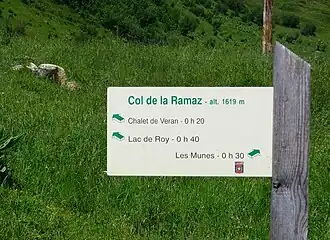
Col de la Ramaz (pronounced with a silent z "Ramá") (elevation 1559 m.) is a high mountain pass in the Alps in the department of Haute-Savoie in France through which the Tour de France passed during 2003, 2010, 2016 and the 2023 race).[1][2][3] The road through the pass culminates slightly higher, at 1619m (5312 feet).
Details of the Climb
From Mieussy (southwest), the climb is 14.05 km long, with elevation gain of 982 m, an average gradient of 7%, and maximum gradient of 12%.[4]
From Taninges (south), the climb is 16 km long, with elevation gain of 970 m, an average gradient of 6.1%, and maximum gradient of 10.6%.[5]
Appearances in the Tour de France
| Year | Stage | Category | Start | Finish | Leader at the summit |
|---|---|---|---|---|---|
| 2023 | 14 | 1 | Annemasse | Morzine | |
| 2016 | 20 | 1 | Megève | Morzine | |
| 2010 | 8 | 1 | Station des Rousses | Morzine-Avoriaz | |
| 2003 | 7 | 1 | Lyon | Morzine | |
| 1981 | 16 | 1 | Thonon-les-Bains | Morzine |
See also
References
- ^ Will (9 July 2010). "Tour de France preview cycling Col de la Ramaz". Cycling Challenge. Retrieved 19 July 2015.
- ^ "Stage 20 - Megève > Morzine-Avoriaz - Tour de France 2016". Archived from the original on 2016-07-01. Retrieved 2016-10-21.
- ^ "Le col de la Ramaz dans le Tour de France". www.ledicodutour.com (in French). Retrieved 2022-08-08.
- ^ "Col de la Ramaz from Mieussy : 1616m". Cols-cyclisme. Retrieved 2025-08-04.
- ^ "Col de la Ramaz from Taninges : 1616m". Cols-cyclisme. Retrieved 2025-08-04.