Chapursan
Chipursan
چپورسن | |
|---|---|
 | |
 Chipursan | |
| Coordinates: 36°44′N 74°44′E / 36.733°N 74.733°E | |
| Country | Gilgit-Baltistan |
| Division | Gilgit Division |
| District | Hunza District |
| Tehsil | Gojal |
| Population | |
• Total | 3,000 |
Chipursan (Wakhi: چپورسن; also spelt Chipurson, Chiporson, Chaporsan, Chupurson) is a valley containing approximately eight scattered villages situated in the Gojal Tehsil of the Hunza District of Gilgit-Baltistan.[1] It is located in the northern part of the country, close to the border with the Wakhan District of the Badakhshan Province of Afghanistan and the Xinjiang autonomous region of China. The valley is predominantly inhabited by ethnic Wakhis; the village of Raminj in this region is inhabited by ethnic Burushos. The valley's inhabitants largely adhere to the Isma'ili sect of Shia Islam. Chapurson hosts over 500 households with an estimated population of 3000 people.
Geography
The Chipurson valley is above 3,000 meters (9,800 ft) from sea level,[2] and the villages are Yarzerech, Raminj, Kirmin, Khill, Rashet, Sheresubz, Ispenj, Shetmerg and Zood Khun.[3]
After Zood Khun pastures are Yashkuk, Kukchaizem, Biban Joi, Kohrben, Korkot, Joi Sam, Dainkut, Khudayar Alga, Kimkut and Baba Ghundi, a major shrine in the Hunza District which is visited by many all year round. Further ahead lie Yashwoshitk, Shipodkut, Pomiri (Pamiri), Pamir and more. All the names of villages and pastures are in Wakhi language.
The valley is full of peaks and passes. Passes include Irshad Pass between Pakistan and Afghanistan and Lupghar Pir Pass between Yeshkuk and Raminj village. Peaks include Sakar Sar,[4][5] Kumpire Dior, Pamir Sar, Sarmaya Sar, Kuksar, and Lupghar Sar.
Sites of interest
Chapursan Valley has historical places.[6] like Yaskuk, Rovai Sam, Khumpir Dior, and the Shrine of Baba Ghundi.
Shrine of Baba Ghundi (Baba Ghundi Ziarat) in the Chuparsan Valley is the shrine of the famous Pir of Ghund who is celebrated in legend as the Sufi saint who brought Islam to the valley.[7] The saint is not actually buried here. The former Mir of Hunza kept his herds of sheep and goats for grazing around here and used to visit the shrine every year. The people of Hunza Valley also revere the saint and it is said that children who are a problem for their parents have only to taste the mud from a stream near Baba Ghundi to become obedient and well behaved.
Peaks, Passes, and Glaciers of Chapurson
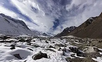
The Chapurson Valley (also spelled Chapursan or Chapurson) is a remote valley located in the Upper Hunza region of Gilgit-Baltistan Known for its rugged, high-altitude terrain, the valley is characterized by numerous towering peaks, challenging mountain passes, and extensive glaciers, forming a significant part of the Karakoram mountain range. The region is sparsely populated and is primarily inhabited by the Wakhi people.
Geographical Features
The geography of Chapurson is dominated by its mountainous environment. Elevations range from approximately 3,700 meters (12,100 ft) at lower localities to over 7,000 meters (23,000 ft) at its highest peaks. The valleys are typically narrow, with steep slopes leading up to vast ice fields and rock faces.
Peaks
The Chapurson Valley is home to several prominent peaks, many of which exceed 6,000 meters (20,000 ft) in elevation. These peaks present significant challenges for mountaineers due to their technical difficulty and remote locations.
| S.No. | Peak Name | Elevation (m) | Elevation (ft) | Notes |
|---|---|---|---|---|
| 01 | Kumpir Dior Sar | 7168 | 23,517 | Also known as Kampire Dior; one of the highest peaks in the region. |
| 02 | Pamir Sar | 7016 | 23,018 | Located in the Karakoram range. |
| 03 | Kuk Sar | 6943 | 22,779 | |
| 04 | Kuk Sar 2 | 6925 | 22,719 | |
| 05 | Khuz Sar (Koz Sar) | 6677 | 21,906 | |
| 06 | Yishkuk Sar (Yashkuk Sar) | 6668 | 21,877 | |
| 07 | Kumpire Doir Sar 2 | 6572 | 21,562 | |
| 09 | Sakar Sar | 6272 | 20,577 | |
| 10 | Yishkuk Sar 2 | 6244 | 20,486 | |
| 11 | Nadim Sar | 6211 | 20,377 | |
| 12 | Caboom Sar | 6186 | 20,295 | |
| 13 | Dehli Sangi-sar | 6165 | 20,226 | |
| 14 | Mamu Sar | 6096 | 19,999 | |
| 15 | Lupsuk Sar | 6082 | 19,954 | |
| 16 | Zood Khun Peak | 6080 | 19,948 | |
| 17 | Kutshkulin Sar | 6074 | 19,928 | |
| 18 | Constanzia Sar | 5902 | 19,364 | |
| 19 | Ghorhill Sar | 5800 | 19,029 | |
| 20 | Jahangir Sar | 5800 | 19,029 | |
| 21 | Baden Sar | 5455 | 17,897 | |
| 22 | Reshitipur Sar | 5413 | 17,760 | |
| 23 | Sumayar Sar | 5221 | 17,130 | |
| 24 | Spandrin Sar | 4829 | 15,843 | |
| 25 | Raminji Sar | 4651 | 15,259 | |
| 26 | Suki Yenj | 4431 | 14,537 | |
| 27 | Pamiri Sar 1 and 2 | N/A | N/A | Mentioned as being further beyond Zood Khun. |
Passes
Mountain passes in Chapurson serve as crucial routes for local communities and historical trade, connecting the valley with neighboring regions and even across international borders.
| S.No. | Pass Name | Elevation (m) | Elevation (ft) | Lie Between |
|---|---|---|---|---|
| 01 | Chilinji Pass | 5411 | 17,753 | Karambar valley in Ishkoman with the Chapursan Valley. |
| 02 | Irshad Pass (Irshod Uwin) | 4963 | 16,283 | Chapurson, Gilgit-Baltistan, and Wakhan Corridor, Afghanistan. Historically significant for cross-border movement. |
| 03 | Lupghar Pir Pass | 5190 | 17,028 | Chapurson - Yashkuk to Raminj Village. |
| 04 | ShuvQuir | 4430 | 14,534 | Chapurson - Misgar. |
| 05 | Ghulam Ali Pass | N/A | N/A |
Glaciers and Localities
The valleys and lower slopes of Chapurson are shaped by the presence of several significant glaciers, which are vital water sources and influence the local climate and ecology. Surrounding these glaciers are various small localities.
| S.No. | Name | Type | Elevation (m) | Elevation (ft) | Detail | Associated Peaks/Passes |
|---|---|---|---|---|---|---|
| 01 | Shikardesh Kuk | Locality | 3751 | 12,306 | A locality in Hunza-Nagar District, Gilgit-Baltistan, situated near Lal Mitti and Kuk Jerab. | Kuz Sar, Kumpire Dior Sar |
| 02 | Kuk Jerab | Locality | 3910 | 12,828 | A locality in Hunza-Nagar District, Gilgit-Baltistan, situated near Lal Mitti and Shikardesh Kuk. | Kuk Sar, Pamir Sar, Lupghar Pir Pass, Lupghar Group |
| 03 | Yashkuk Yaz Glacier | Glacier | 3929 | 12,890 | A glacier located near Pamri and Shikardesh Kuk. | Yishkuk Sar (Yashkuk Sar), Nadim Sar, Cobeen Sar, Jahangir Sar, Kumpire Dior, Koz Sar, Mamu Sar |
| 04 | Chillinji Glacier | Glacier | 3848 | 12,625 | Koz Sar | |
| 05 | Ghulam Ali Pass | Pass (also a feature) | N/A | N/A | ||
| 06 | Biyater | Locality | 4027 | 13,212 | A locality in Hunza-Nagar District, Gilgit-Baltistan, situated near Yoe Virt and Beskiyeng. | |
| 07 | Qoz Yaz Glacier | Glacier | 4049 | 13,284 | A glacier situated near Biyatar and Beskiyeng. |
See also
- Hunza Valley
- Gilgit-Baltistan
- Karakoram
References
- ^ "Footloose, NOS, The News International". jang.com.pk.
- ^ "A Guide To Chapursan Valley In Northern Pakistan - Lost With Purpose". 2019-05-15. Retrieved 2025-04-09.
- ^ "At the knot of past empires: Zood Khun, a Wakhi village in the high northern mountains of Pakistan". PAMIR TIMES. Retrieved 2025-04-13.
- ^ "Where are the Hindu Kush Mountains?". WorldAtlas. 10 January 2019. Retrieved 2021-08-18.
- ^ "Sakar Sar" on nazirsabir.com Listed as "Sakar Sar".
- ^ "Chapursan Valley Travel Guide: Journey to the End of the World". OFF THE ATLAS. Retrieved 2021-11-08.
- ^ Nagri, Jamil (October 3, 2015). "Hunza's Baba Ghundi Festival concludes". DAWN. Retrieved 16 December 2019.
The festival was held at the shrine of Baba Ghundi to pay homage to the Sufi saint for his pioneering role in the spread of Islam in the region.