California Historical Landmarks located in Plumas County, California are listed.
Note the "Map of all coordinates using: OpenStreetMap" link below. Click on that link to view a map showing the locations of all the Plumas County historical properties and districts that are listed in the table.
Image
[ 1] Landmark name
Location
City or town
Summary
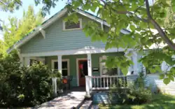
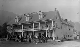
American Ranch and Hotel 479
American Ranch and Hotel
355 Main St. 39°56′13″N 120°56′43″W / 39.93701°N 120.945323°W / 39.93701; -120.945323 (American Ranch and Hotel ) Quincy
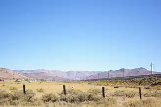
Beckwourth Pass 336
Beckwourth Pass
Rest area, Beckwourth Pass 39°47′30″N 120°06′28″W / 39.791667°N 120.107778°W / 39.791667; -120.107778 (Beckwourth Pass ) Chilcoot
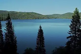
Bucks Lake 197
Bucks Lake
Bucks Lake Lodge Marina 39°52′45″N 121°10′34″W / 39.87915°N 121.176183°W / 39.87915; -121.176183 (Bucks Lake ) Bucks Lake
Elizabethtown 231
Elizabethtown
On dirt rd, 0.4 mi NW of State Hwy 70 39°57′50″N 120°57′25″W / 39.963839°N 120.957081°W / 39.963839; -120.957081 (Elizabethtown ) Quincy
Jamison City, Eureka Mills, Johnstown, and the famous Eureka Mine 196
Jamison City, Eureka Mills, Johnstown, and the famous Eureka Mine
Plumas-Eureka State Park 39°47′18″N 120°38′04″W / 39.788383°N 120.634317°W / 39.788383; -120.634317 (Jamison City, Eureka Mills, Johnstown, and the famous Eureka Mine ) Blairsden
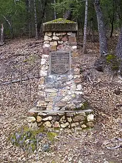
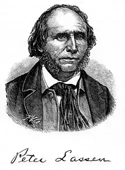
Peter Lassen Marker 184
Peter Lassen Marker
North Valley Rd. 40°08′59″N 120°52′46″W / 40.149717°N 120.87945°W / 40.149717; -120.87945 (Peter Lassen Marker ) Greenville
Upload Photo
212
Pioneer Grave
Buck's Lake Rd. 39°51′49″N 121°13′37″W / 39.863517°N 121.226833°W / 39.863517; -121.226833 (Pioneer Grave ) Quincy
Upload Photo
625
Pioneer Schoolhouse
Plumas County Fairgrounds 39°56′20″N 120°54′56″W / 39.938933°N 120.915617°W / 39.938933; -120.915617 (Pioneer Schoolhouse ) Quincy
Johnsville Ski Area 723
Johnsville Ski Area
Plumas-Eureka State Park 39°45′24″N 120°41′52″W / 39.756617°N 120.697683°W / 39.756617; -120.697683 (Johnsville Ski Area ) Blairsden
Plumas House 480
Plumas House
Main and Court Sts. 39°56′10″N 120°56′53″W / 39.936000°N 120.948000°W / 39.936000; -120.948000 (Plumas House ) Quincy
Upload Photo
213
Rabbit Creek Hotel Monument
Main and Church Sts 39°40′58″N 120°59′05″W / 39.682883°N 120.9846°W / 39.682883; -120.9846 (Rabbit Creek Hotel Monument ) La Porte
Upload Photo
337
Rich Bar
Rich Bar, on State Hwy 70 40°00′43″N 121°11′35″W / 40.012017°N 121.193°W / 40.012017; -121.193 (Rich Bar ) Quincy
Upload Photo
481
Spanish Ranch
Spanish Ranch Rd. 39°57′00″N 121°03′25″W / 39.95005°N 121.056983°W / 39.95005; -121.056983 (Spanish Ranch ) Spanish Ranch
References
See also
Parks Preserves Monuments Seashores Historical Parks Historic Sites Memorials Recreation Areas
Parks Natural Reserves Marine Reserves Historic Parks Beaches Recreation Areas Vehicular Other
National Forests National Wilderness National Monuments
Wildlife Ecological Marine
National Monuments National Wilderness Areas