Antonia Island
Native name: Cabugao Gamay | |
|---|---|
 | |
.svg.png) Antonia Island Location within the Philippines | |
| Geography | |
| Location | Visayan Sea |
| Coordinates | 11°33′26″N 123°20′45″E / 11.55722°N 123.34583°E |
| Archipelago | Islas de Gigantes |
| Highest elevation | 357 ft (108.8 m)[1] |
| Administration | |
| Region | Western Visayas |
| Province | Iloilo |
| Municipality | Carles |
| Demographics | |
| Population | uninhabited |
Antonia Island, locally known as Cabugao Gamay [lit. 'Little Cabugao'] because of the bigger island north of it named Cabugao that locals refer to as Cabugao Daku [lit. 'Big Cabugao'], is a small, uninhabited island in northeastern Iloilo, Philippines. It is one of fourteen islands politically administered by the municipality of Carles. Along with Bantigui Island and Cabugao Island, it is one of three minor southern islets in the Islas de Gigantes archipelago.
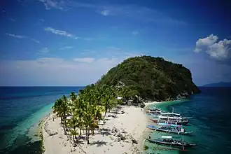
The island is a well-known location in the archipelago, referred to as "selfie island" because of its viewpoint overlooking the island's center beaches and the hill with vegetation at its southern end.[2]
Location and geography
Cabugao Gamay is a small island northeast of the Panay Island coast in the Visayan Sea. It is 0.5 kilometres (0.31 mi) south of Gigantes Sur and is part of the Islas de Gigantes island group.[1] Cabugao Gamay is a widely photographed island in Islas de Gigantes and is often part of island-hopping tours of the archipelago. It features two white sand beaches that form like a sandbar connecting two islets.
See also
References
- ^ a b U.S. Coast and Geodetic Survey, Reuben Jacob Christman (1919). United States Coast Pilot, Philippine Islands, Part 1. U.S. Government Printing Office. p. 221. Retrieved 30 June 2014.
- ^ "Cabugao Gamay | Gigantes Island Travel Guide, Packages, Destinations, Accommodations, Resorts, Airport, Etc. | Cabugao Gamay Island | Islas de Gigantes Tour Packages, Attractions, Hotels, Resorts, Flights, Itinerary & More". Retrieved 2025-01-31.