Buildings in the Charleston Historic District
The Charleston Historic District is a large urban U.S. historic district in Charleston, South Carolina that consists of most of the historic peninsular heart of the city. It was the first historic district designated by any government in the U.S., when it was established in 1931. The district was expanded, then it was designated a National Historic Landmark District in 1960. A further expanded area was listed on the National Register of Historic Places in 1966.[1][2]
The district covers most of the historic peninsular heart of the city and contains an unparalleled collection of 18th and 19th-century architecture, including many distinctive Charleston "single houses". It was declared to be a National Historic Landmark in 1960.[3]
According to the New York Preservation Archive Project, the Charleston Old and Historic District's creation in 1931 established "the first historic district protected by local legislation in the United States and inspired legal protection of historic sites in New York City."[4]
The district was about 770 acres (1.20 sq mi; 3.1 km2) in area in 1966.[1] Maps of the original 1931 district (which became a National Historic Landmark in 1960), the expansion of that National Historic Landmark district in 1966, and the greater area covered in the 1975 listing on the National Register of Historic Places, are on pages 281-84 of NARA collection. What NARA currently provides at "Charleston Historic District" is very different from a regular NRHP or NHL submission; it includes no NRHP or NHL forms at all. Instead it includes much correspondence relating to the designation of the Charleston Historic District as an NHL. It in fact includes the nationwide study of which places were obviously eligible for NHL designation in 1960, a list including the Charleston Historic District. This was conveyed in an October 9, 1960, release from U.S. Secretary of the Interior Fred A. Seaton (pages 36–55). This includes a nationwide list of sites eligible (p. 38-53). An outline of themes identified in the National Survey of Historic Sites and Buildings (which the National Park Service? was authorized to undertake in 1935 legislation) is (p. 54-55). (Charleston Mayor J. Palmer Gaillard, Jr. formally accepted the designation in 1962; not all other NHL candidate places did.) Includes correspondence, photos, plans, more.[5]
At least 46 buildings in the district have been documented by the Historic American Buildings Survey (HABS).
Below is a partial list of relevant buildings inside the Charleston Historic District:
Selected contributing properties
| Name | Image | Address | Dates | Note |
|---|---|---|---|---|
| "Pink House", 17 Chalmers Street | 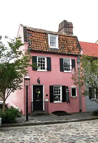
|
17 Chalmers Street 32°46′39″N 79°55′44″W / 32.77756°N 79.92895°W |
1694-1712 HABS-doc'd[6] |
Second-oldest house in Charleston, built of pink Bermuda stone. |
| 59 Smith Street (House) | 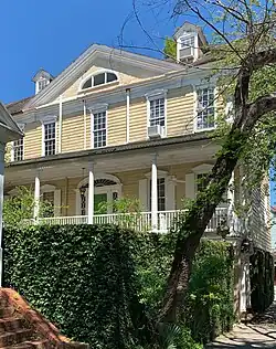
|
59 Smith Street 32°46′53″N 79°56′28″W / 32.78147°N 79.94119°W |
HABS-doc'd[7] | |
| 74 Rutledge Avenue (House) | .jpg)
|
74 Rutledge Avenue, at Wentworth St. 32°46′46″N 79°56′29″W / 32.77949°N 79.94136°W |
HABS-doc'd[8] | |
| Bank of South Carolina aka "Chamber of Commerce" aka "Citizens and Southern National Bank Building" | 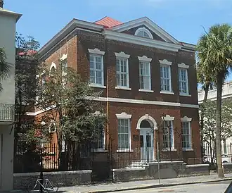
|
50 Broad St. 32°46′37″N 79°55′46″W / 32.77684°N 79.92943°W |
HABS-doc'd[9] | |
| Bank of United States, now City Hall | 
|
NE corner Broad and Meeting Sts. 32°46′36″N 79°55′51″W / 32.77672°N 79.93083°W |
HABS-doc'd[10] | |
| Governor Thomas Bennett House | 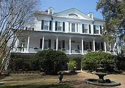
|
89 Smith St. 32°46′59″N 79°56′32″W / 32.78316°N 79.94222°W |
1825 built HABS-doc'd |
Interior features one of only two cantilevered staircases in Charleston. HABS-listed |
| William Blacklock House | .jpg)
|
18 Bull St. 32°46′59″N 79°56′22″W / 32.78305°N 79.93949°W |
HABS-doc'd | |
| William Blacklock Carriage House | 
|
18 Bull St. 32°47′00″N 79°56′22″W / 32.78329°N 79.93951°W |
HABS-doc'd | [11] |
| Blacklock Gazebo | 
|
18 Bull St. 32°47′00″N 79°56′23″W / 32.78330°N 79.93974°W |
HABS-doc'd[12] | Garden pavilion, about 10 by 14 feet (3.0 m × 4.3 m), brick laid in Flemish Bond, built probably same time as house.[13] |
| Daniel Blake Tenement | 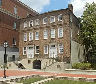
|
2-4 Courthouse Square |
HABS-doc'd | [14] |
| Major Peter Bocquet Jr. House | 
|
95 Broad St. 32°46′34″N 79°55′56″W / 32.77625°N 79.93223°W |
c.1962 HABS-doc'd | 3½-story house, about 30 by 58 feet (9.1 m × 17.7 m) in plan[15][16] |
| Charleston County Courthouse | .jpg)
|
NW corner Broad and Meeting Sts. 32°46′35.814″N 79°55′52.752″W / 32.77661500°N 79.93132000°W |
1790-92 built HABS-doc'd |
[17] |
| Alexander Robert Chisholm House | 
|
6 Montague St. 32°46′56″N 79°56′19″W / 32.78219°N 79.93852°W |
HABS-doc'd[18] | |
| College of Charleston's Randolph Hall | 
|
66 George St. 32°47′02″N 79°56′15″W / 32.78402°N 79.93740°W |
HABS-doc'd[19] | |
| County Records Building, aka "Fireproof Building" | 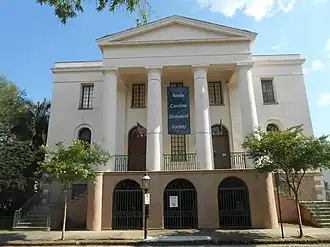
|
100 Meeting St. at Chalmers St. 32°46′38″N 79°55′51″W / 32.77720°N 79.93091°W |
1822–27 built NRHP 1969 NHL 1973 HABS-doc'd[20] |
Earliest "Fireproof Building" in the United States, designed by Robert Mills, now the South Carolina Historical Society. |
| Exchange Building and Custom House | 
|
122-26 East Bay St. 32°46′37″N 79°55′37″W / 32.77690°N 79.92688°W |
1973 NHL HABS-doc'd[21] |
Now a museum |
| Farmers' and Exchange Bank | .jpg)
|
141 E. Bay St. 32°46′39.5″N 79°55′38″W / 32.777639°N 79.92722°W |
1854 built NRHP 1983 NHL 1983 HABS-doc'd |
|
| Gate, 96 Ashley Ave. | 
|
96 Ashley Ave. 32°46′47″N 79°56′37″W / 32.77982°N 79.94349°W |
HABS-doc'd[22] | In 2021 Google Streetview imagery, the wrought-iron fence appears intact but the gate has been removed.[23] |
| Glebe House, aka St. Philip's Parsonage House aka Bishop Robert Smith House[24] | 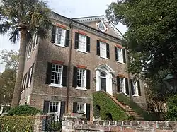
|
6 Glebe St. 32°46′56″N 79°56′11″W / 32.78211°N 79.93634°W |
HABS-doc'd | "A fine eighteenth-century mansion which was the home of the first Episcopal Bishop of South Carolina, and nucleus of the College of Charleston."[25][26] Now "President's House"? |
| Glebe Street Presbyterian Church, now the Mount Zion AME Methodist Church | 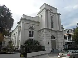
|
7 Glebe St. 32°46′56″N 79°56′13″W / 32.78222°N 79.93693°W |
HABS-doc'd[27] | |
| Dr. Joseph Glover House | 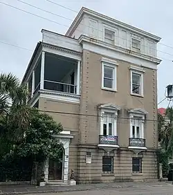
|
81 Rutledge Avenue 32°46′48″N 79°56′31″W / 32.77989°N 79.94205°W |
HABS-doc'd[28] | |
| Harvey-Lining House and Pharmacy | 
|
Broad St. at King St. 32°46′35″N 79°55′58″W / 32.77644°N 79.93287°W |
HABS-doc'd[29] | |
| Hibernian Hall (Charleston, South Carolina) | 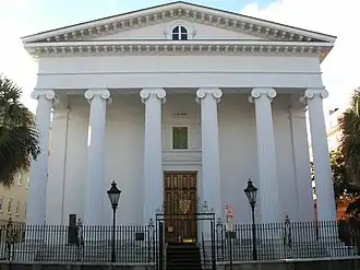
|
105 Meeting St. 32°46′38″N 79°55′54″W / 32.77722°N 79.93167°W |
HABS-doc'd | |
| Kings Courtyard Inn | 198 King Street 32°46′47″N 79°55′58″W / 32.7796°N 79.9329°W |
1833 built | Now a boutique hotel, its building was designed by architect Francis D. Lee mainly in Greek Revival style but with elements of Egyptian Revival. | |
| T. B. Seabrook House | 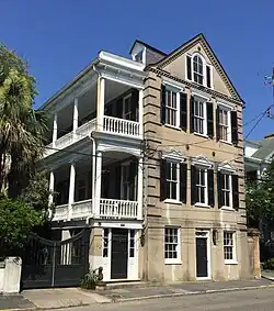
|
95 Rutledge Avenue 32°46′51″N 79°56′33″W / 32.78076°N 79.94252°W |
HABS-doc'd[30] |
See also
References
- ^ a b Stockton, Robert P.; Mrs. S. Henry Edmunds (November 4, 1977). "Old and Historic Charleston (Extended)" (pdf). National Register of Historic Places - Nomination and Inventory. National Park Service. Retrieved May 25, 2012.
- ^ "Charleston Historic District". Photographs. National Park Service. Retrieved May 25, 2012.
- ^ "Charleston Historic District". National Historic Landmark summary listing. National Park Service. Archived from the original on October 23, 2007. Retrieved March 18, 2008.
- ^ "The Old and Historic Charleston District". Retrieved December 16, 2020.
- ^ NARA collection of documents associated with Charleston Historic District. NARA. Retrieved September 8, 2022. 347 pages Downloading may be slow.
- ^ "17 Chalmers Street (House), Charleston, Charleston County, SC". Library of Congress. Retrieved September 8, 2022.
- ^ "59 Smith Street (House), Charleston, Charleston County, SC". Library of Congress. Retrieved September 8, 2022.
- ^ "74 Rutledge Avenue (House), Charleston, Charleston County, SC". Library of Congress. Retrieved September 8, 2022.
- ^ "Chamber of Commerce, 50 Broad Street, Charleston, Charleston County, SC". Library of Congress. Retrieved September 8, 2022.
- ^ "Bank of the United States, 80 Broad Street, Charleston, Charleston County, SC". Library of Congress. Retrieved September 8, 2022.
- ^ "William Blacklock Carriage House, 18 Bull Street, Charleston, Charleston County, SC". Library of Congress. Retrieved September 8, 2022.
- ^ William Blacklock Gazebo, 18 Bull Street, Charleston, Charleston County, SC, at Library of Congress
- ^ HABS data pages: William Blacklock Gazebo. 1962
- ^ "Daniel Blake Tenement, 6-8 (2-4) Courthouse Square, Charleston, Charleston County, SC". Library of Congress. Retrieved September 8, 2022.
- ^ "Major Peter Bocquet, Jr. House, 95 Broad Street, Charleston, Charleston County, SC". Library of Congress. Retrieved September 8, 2022.
- ^ Amelia Whaley (March 25, 2019). "Diary of a Charleston Tour Guide: 95 Broad Street - Peter Bocquet House".
- ^ "Charleston County Courthouse, 82-86 Broad Street, Charleston, Charleston County, SC Photos from Survey HABS SC-131". Library of Congress. Retrieved September 8, 2022.
- ^ "Alexander Robert Chisholm House, 6 Montague Street, Charleston, Charleston County, SC Photos from Survey HABS SC-260". Library of Congress. Retrieved September 8, 2022.
- ^ "College of Charleston, 66 George Street, Charleston, Charleston County, SC". Library of Congress. Retrieved September 8, 2022.
- ^ "HABS SC,10-CHAR,64- (sheet 0 of 7) - County Records Building, 100 Meeting Street (at Chalmers Street), Charleston, Charleston County, SC Drawings from Survey HABS SC-13-2". Library of Congress. Retrieved September 8, 2022.
- ^ "Exchange Building and Custom House, 122-26 East Bay St., Charleston, Charleston County, SC". Library of Congress. Retrieved September 8, 2022.
- ^ "Gate, 96 Ashley Avenue, Charleston, Charleston County, SC". Library of Congress. Retrieved September 8, 2022.
- ^ Google Streetview imagery of December 2021, accessed September 9, 2022.
- ^ Historic Charleston Foundation: 6 Glebe Street (St. Philip's Parsonage House/Bishop Robert Smith House)
- ^ HABS data pages: Glebe House
- ^ Glebe House, at Library of Congress, 21 photos from HABS
- ^ "Glebe Street Presbyterian Church, 7 Glebe Street, Charleston, Charleston County, SC". Library of Congress. Retrieved September 8, 2022.
- ^ "Dr. Joseph Glover House, 81 Rutledge Avenue, Charleston, Charleston County, SC". Library of Congress. Retrieved September 8, 2022.
- ^ "Harvey-Lining House & Pharmacy, Broad & Kings Streets, Charleston, Charleston County, SC". Library of Congress. Retrieved September 8, 2022.
- ^ "T. B. Seabrook House, 95 Rutledge Avenue, Charleston, Charleston County, SC". Library of Congress. Retrieved September 8, 2022.