Brownlee, Nebraska
Brownlee, Nebraska | |
|---|---|
 | |
 Brownlee, Nebraska  Brownlee, Nebraska | |
| Coordinates: 42°18′N 100°36′W / 42.3°N 100.6°W | |
| Country | |
| State | |
| County | Cherry |
| Area | |
• Total | 0.11 sq mi (0.28 km2) |
| • Land | 0.11 sq mi (0.28 km2) |
| • Water | 0.00 sq mi (0.00 km2) |
| Elevation | 2,871 ft (875 m) |
| Population (2020) | |
• Total | 13 |
| • Density | 122.64/sq mi (47.19/km2) |
| ZIP code | 69166[3] |
| Area code | 308 |
| FIPS code | 31-06680 |
| GNIS feature ID | 2583877[2] |
Brownlee is an unincorporated community and census-designated place in Cherry County, Nebraska, United States.[2] As of the 2020 census it had a population of 13.[4] It is located on the North Loup River, 5 miles (8 km) west of U.S. Route 83 in the Sandhills region of the state.
History
Founded in 1886 by John R. Lee and William B. Lee, immigrants from Ireland. Brownlee was given the maiden name of the founder's grandmother.[5]
-
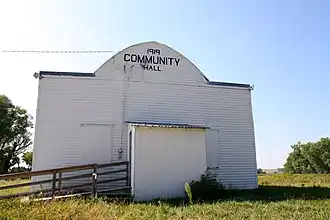 Community Hall
 -
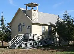 Brownlee church
Demographics
| Census | Pop. | Note | %± |
|---|---|---|---|
| 2010 | 15 | — | |
| 2020 | 13 | −13.3% | |
| U.S. Decennial Census[6] | |||
References
- ^ "ArcGIS REST Services Directory". United States Census Bureau. Retrieved September 19, 2022.
- ^ a b c U.S. Geological Survey Geographic Names Information System: Brownlee, Nebraska
- ^ "Brownlee NE ZIP Code". zipdatamaps.com. 2024. Retrieved February 5, 2024.
- ^ "Brownlee CDP, Nebraska". United States Census Bureau. Retrieved July 24, 2025.
- ^ Federal Writers' Project (1938). Origin of Nebraska place names. Lincoln, NE: Works Progress Administration. p. 7.
- ^ "Census of Population and Housing". Census.gov. Retrieved June 4, 2016.
Wikimedia Commons has media related to Brownlee, Nebraska.
Municipalities and communities of Cherry County, Nebraska, United States | ||
|---|---|---|
| City |  | |
| Villages | ||
| CDP | ||
| Other unincorporated communities | ||
| Ghost towns | ||
42°17′17″N 100°37′33″W / 42.28806°N 100.62583°W