Bootle Balliol Road railway station
Bootle Balliol Road | |||||
|---|---|---|---|---|---|
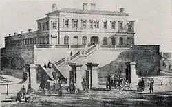
 Balliol Road's platforms would have ended just before the tunnel | |||||
| General information | |||||
| Location | Bootle, Sefton England | ||||
| Coordinates | 53°26′41″N 2°59′41″W / 53.4448°N 2.9948°W | ||||
| Grid reference | SJ 340 946 | ||||
| Platforms | 2[1] | ||||
| Other information | |||||
| Status | Disused | ||||
| History | |||||
| Original company | London and North Western Railway | ||||
| Pre-grouping | London and North Western Railway | ||||
| Post-grouping | London Midland and Scottish Railway | ||||
| Key dates | |||||
| 5 September 1881 | Opened as Balliol Road | ||||
| 1 January 1891 | Renamed Bootle Balliol Road | ||||
| 31 May 1948 | Last passenger train called | ||||
| 26 February 1949 | Officially closed | ||||
| |||||
Balliol Road railway station was on the Alexandra Dock Branch, Bootle, Merseyside, England, it opened on 5 September 1881[2] and closed to passengers on 31 May 1948. Goods trains to and from Seaforth Dock still pass through the station site.
References
Sources
- Butt, R. V. J. (October 1995). The Directory of Railway Stations: details every public and private passenger station, halt, platform and stopping place, past and present (1st ed.). Sparkford: Patrick Stephens Ltd. ISBN 978-1-85260-508-7. OCLC 60251199. OL 11956311M.
- Gell, Rob (1985). An Illustrated Survey of Liverpool's Railway Stations 1830-1985. Crosby, Merseyside: Heyday Publishing. ISBN 978-0-947562-03-8.
External links
- The station's history Disused Stations
- The station and local lines on multiple maps Rail Maps Online
- The station on a 25" Edwardian OS Map National Library of Scotland
- The station on line SCT2, with mileages Railway Codes
| Preceding station | Disused railways | Following station | ||
|---|---|---|---|---|
| Alexandra Dock Line and station closed |
London and North Western Railway Alexandra Dock Branch |
Spellow Line and station closed |


.jpg)