Banyuasin Regency
Banyuasin Regency
Kabupaten Banyuasin | |
|---|---|
| Other transcription(s) | |
| • Musi | Ayomasen |
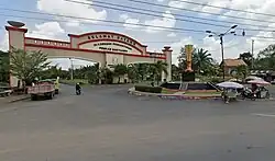 Government complex in Pangkalan Balai | |
 Coat of arms | |
| Etymology: ꦧꦚꦸꦲꦱꦶꦤ꧀ (Javanese) Banyuasin "Seawater" | |
| Motto(s): | |
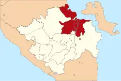 Location within South Sumatera | |
| Coordinates: 2°10′S 104°09′E / 2.16°S 104.15°E | |
| Sovereign state | |
| Province | South Sumatra |
| Regency seat | Pangkalan Balai |
| Onder Afdeeling (Dutch rule) | ca.1900 |
| Karesidenan | as Palembang ca.1945 |
| Kabupaten (Regency) | as Musi Banyuasin |
| Kabupaten (Regency) | since 2002 |
| Government | |
| • Type | Regency |
| • Regent / Bupati | Askolani Jasi (PDIP) |
| • Vice Regent / Wakil Bupati | Netta Indian |
| Area | |
• Total | 12,551.15 km2 (4,846.03 sq mi) |
| Population (mid 2024 estimate)[1] | |
• Total | 888,324 |
| • Density | 71/km2 (180/sq mi) |
| • Ethnic groups | |
| Time zone | UTC+7 (Western Indonesia Time) |
| Postcode | 309xx |
| Area code | + 62 711 : 0711 |
| Distance from Pangkalan Balai to Palembang | 63 km |
| Website | banyuasinkab.go.id |
Banyuasin Regency (Musi: Ayomasen) is a regency of South Sumatra Province in Indonesia. The Regency was formed on 10 April 2002 from the coastal and eastern areas formerly part of the Musi Banyuasin Regency. It takes its name from the main river which drains that area, the Banyuasin River. Pangkalan Balai is the regency seat. The regency borders Musi Banyuasin Regency, Jambi province and Bangka Strait to the north, Bangka Strait to the east, Ogan Komering Ilir Regency, Muara Enim Regency, and the city of Palembang (which it almost surrounds on most sides) to the south, and Musi Banyuasin Regency to the west.[2] It has an area of 12,551.15 km2 and had a population of 749,107 at the 2010 census[3] and 836,914 at the 2020 census;[4] the official estimate as at mid 2024 was 888,324 (comprising 454,414 males and 433,910 females).[1] Much of the regency is coastal lowland.[5]
Administrative districts
As at 2010, the Banyuasin Regency was subdivided into fifteen districts (kecamatan), subsequently increased by six to twenty-one districts which are listed below with their areas and their populations at the 2010[3] and 2020[4] censuses, together with the official estimates as at mid 2024.[1] The table also includes the location of the district administrative centres, the number of administrative villages in each district (totaling 288 rural desa and 25 urban kelurahan), and its post code.
| Kode Wilayah |
Name of District (kecamatan) |
Area in km2 |
Pop'n 2010 census |
Pop'n 2020 census |
Pop'n mid 2024 estimate |
Admin centre |
No. of villages |
Post code |
|---|---|---|---|---|---|---|---|---|
| 16.07.11 | Rantau Bayur * | 535.07 | 38,319 | 41,390 | 41,561 | Tebing Abang | 21 | 30968 |
| 16.07.05 | Betung | 388.99 | 55,922 | 54,750 | 56,581 | Betung | 12 (a) | 30958 |
| 16.07.16 | Suak Tapeh | 322.51 | (b) | 18,960 | 20,028 | Lubuk Lancang | 11 | 30957 |
| 16.07.04 | Pulau Rimau | 503.94 | 38,454 | 21,360 | 25,007 | Teluk Betung | 17 | 30959 |
| 16.07.15 | Tungkal Ilir | 686.30 | 23,281 | 28,810 | 30,232 | Sido Mulyo | 14 | 30956 |
| 16.07.21 | Selat Penuguan | 136.39 | (c) | 22,670 | 23,742 | Wonodadi | 12 | 30959 |
| 16.07.05 | Banyuasin III * | 679.36 | 86,183 | 66,420 | 71,278 | Pangkalan Balai | 26 (d) | 30953 (e) |
| 16.07.17 | Sembawa | 220.32 | (f) | 32,290 | 34,909 | Sembawa | 11 | 30953 |
| 16.07.10 | Talung Kelapa * | 478.85 | 123,192 | 150,976 | 160,811 | Sukajadi | 19 (g) | 30961 |
| 16.07.12 | Tanjung Lago | 533.22 | 35,687 | 40,460 | 44,121 | Tanjung Lado | 15 | 30960 |
| 16.07.01 | Banyuasin I * | 214.70 | 69,860 | 54,380 | 60,039 | Mariana | 13 (h) | 30963 |
| 16.07.19 | Air Kumbang | 343.43 | (i) | 26,076 | 29,457 | Cinta Manis Baru | 16 | 30962 |
| 16.07.06 | Rambutan * | 586.82 | 41,953 | 45,592 | 45,879 | Rambutan | 20 (j) | 30967 |
| 16.07.07 | Muara Padang | 945.21 | 25,198 | 31,890 | 33,386 | Muara Padang | 15 | 30975 |
| 16.07.13 | Muara Sugihan | 679.41 | 36,971 | 38,210 | 41,038 | Tirta Harja | 22 | 30976 |
| 16.07.09 | Makarti Jaya | 327.17 | 32,819 | 25,450 | 24,866 | Makarti Jaya | 12 (k) | 30972 |
| 16.07.14 | Air Saleh | 338.68 | 28,858 | 34,920 | 36,650 | Saleh Mukti | 14 | 30973 |
| 16.07.02 | Banyuasin II | 3,611.53 | 45,072 | 29,267 | 30,585 | Sungsang I | 10 | 30971 |
| 16.07.20 | Karang Agung Ilir | 437.69 | (l) | 11,410 | 12,406 | Jati Sari | 7 | 30971 |
| 16.07.08 | Muara Telang | 364.16 | 52,783 | 37,580 | 40,489 | Telang Jaya | 16 | 30974 |
| 16.07.18 | Sumber Marga Telang | 217.38 | (m) | 24,050 | 25,259 | Muara Telang | 10 | 30977 |
| Totals | 12,551.15 | 749,107 | 836,914 | 888,324 | Pangkalan Balai | 313 |
Notes:
(a) includes 2 kelurahan (Betung and Rimba Asam).
(b) 2010 population included in figure for Betung and Banyuasin III Districts, from parts of which it was created in 2011.
(c) 2010 population included in figure for Pulau Rimau District, from part of which it was created.
(d) comprises 5 kelurahan (Kayuara Kuning, Kedondong Raye, Mulya Agung, Pangkalan Balai and Seterio) and 21 desa.
(e) except for the villages of Pangkalan Balai (which has a postcode of 30911), Seterio (30912), Sukaraja Baru (30913), Mulya Agung (30914), Kayuara Kuning (30915) and Sukamulya (30916).
(f) 2010 population included in figure for Banyuasin III District, from part of which it was created in 2011.
(g) following re-organisation in 2022, now comprises 13 kelurahan (Sukajadi, Sukajadi Timur, Kenten, Sei Sedapat, Azhar Permai, Sukamoro, Rawamaju, Air Batu, Air Batu Jaya, Tanah Mas, Tanah Mas Indah, Talang Keramat and Keramat Jaya) and 7 desa. Of the kelurahan, Sukajadi had 21,151 inhabitants as at mid 2023, Kenten had 17,699, Sukamoro has 15,551, Tanah Mas had 12,207, Sukajadi Timur had 20,735, Air Batu had 10,613 and Talang Keramat had 2,913, while the most populous desa was Kenten Laut (with 10,685).
(h) includes 2 kelurahan (Mariana and Mariana Ilir).
(i) 2010 population included in figure for Banyuasin I and Rambutan Districts, from parts of which it was created in 2012.
(j) includes one kelurahan (Jakabaring Selatan). (k) includes one kelurahan (Makarti Jaya).
(l) 2010 population included in figure for Banyuasin II District, from part of which it was created.
(m) 2010 population included in figure for Muara Telang District, from part of which it was created in 2016.
Five of the above districts, indicated by an asterisk (*) following their name in the first column, are immediately adjacent to Palembang City and contain suburbs of that city, and form part of the Palembang metropolitan area.
Of the Regency's 25 kelurahan, 13 are in Talang Kelapa District, 5 in Banyuasin III District, 2 each in Betung District and Banyuasin I District, and 1 each in Rambutan District and Makarti Jaya District. Average land area of all 288 desa is 43.58 km2 (16.83 sq mi)
References
- ^ a b c Badan Pusat Statistik, Jakarta, 28 February 2025, Kabupaten Banyuasin Dalam Angka 2025 (Katalog-BPS 1102001.1607)
- ^ "Portal Resmi Pemerintah Kabupaten Banyuasin".
- ^ a b Biro Pusat Statistik, Jakarta, 2011.
- ^ a b Badan Pusat Statistik, Jakarta, 2021.
- ^ Potential and prospects for development Archived July 4, 2011, at the Wayback Machine, Simperdal, accessed 19 February 2011
Regencies and cities of South Sumatra | ||
|---|---|---|
Capital: Palembang | ||
| Regencies | ||
| Cities | ||