Bachtel Tower
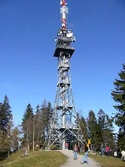
Bachtel Tower (German: Bachtelturm) is a 75-metre-high observation and transmitting tower located on the summit of the Bachtel mountain in the Zürcher Oberland region of Switzerland.[1][2] Built in 1986, it has an observation platform 30 metres above ground level, offering views from Lake Zurich to the Black Forest in good weather.[1] The structure replaced an earlier steel observation tower from 1893, which is now re-erected on the Pfannenstiel.[1][2]
History
In 1873, a wooden observation tower was built on the Bachtel.[1] To increase its attractiveness, the landlord of the first guest house on the mountain added a viewing platform with coloured windows.[2] In January 1890, a winter storm swept over the area, destroying the tower and leaving behind only timber and shards of coloured glass.[2]
Members of the Swiss Alpine Club’s Section Bachtel collected funds to build a replacement steel tower with a viewing platform and a peak map showing the surrounding mountains.[2] Erected in 1893, the steel lattice tower remained on the summit until 1985, when it was dismantled because it was no longer suitable as an antenna support.[1] After renovation, it was re-erected seven years later on the Pfannenstiel, where it is still known as the old Bachtel tower.[1][2]
Tourism
The Bachtel, sometimes called the “Rigi” of the Zürcher Oberland, is known for wide-ranging views. Travel guides from the mid-19th century praised its panorama. In 1851, Gottfried von Escher described a broad view stretching from the upper part of Lake Zurich to the Sentis and the high peaks of the Bernese Oberland.[2] The mountain also drew interest from the educated middle class of the time, and in 1849 the panorama artist Heinrich Keller produced an all-round depiction of the view from Bachtel Kulm.[2]

