Anaktuvuk Pass, Alaska
Anaktuvuk Pass
Anaqtuuvak | |
|---|---|
 Aerial view of Anaktuvuk Pass | |
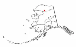 Location in Alaska | |
| Coordinates: 68°08′35″N 151°44′01″W / 68.14306°N 151.73361°W | |
| Country | United States |
| State | Alaska |
| Borough | North Slope |
| Settled | 1949 |
| Incorporated | June 1957[1] |
| Government | |
| • Mayor | Esther Hugo[2] |
| • State senator | Donny Olson (D) |
| • State rep. | Robyn Burke (D) |
| Area | |
• Total | 5.23 sq mi (13.55 km2) |
| • Land | 5.18 sq mi (13.41 km2) |
| • Water | 0.05 sq mi (0.14 km2) |
| Elevation | 2,239 ft (663 m) |
| Population (2020) | |
• Total | 425 |
| • Density | 82.09/sq mi (31.70/km2) |
| Time zone | UTC−09:00 (Alaskan (AKST)) |
| • Summer (DST) | UTC−08:00 (AKDT) |
| ZIP code | 99721 |
| Area code | 907 |
| FIPS code | 02-02080 |
| GNIS feature ID | 1398235, 2419354 |
Anaktuvuk Pass (Inupiaq: Anaqtuuvak, IPA: [ɐnɑqtuːvɐk],[4] Anaqtuġvik or Naqsraq, IPA: [naχʂɑq]) is a city[5][6] in North Slope Borough, Alaska, United States. It is located in the middle of Gates of the Arctic National Park and Preserve. The population was 425 at the 2020 census[7], up from 324 as of the 2010 census.[5]
History
Anaktuvuk Pass was named after the Anaktuvuk River, and lies at the crossing of two mountain valleys. Anaktuvuk is the English way of spelling "anaqtuġvik", place of caribou droppings in Inupiaq, the language of the Inupiat.[8]
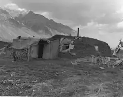
A nomadic group of Inupiat called Nunamiut, meaning 'people of the land', lived inland in northern Alaska, hunting caribou instead of the marine mammals and fish hunted by the rest of the Inupiat, who live on the coast.[9] The Nunamiut traded with the coastal people for other items they needed. A decline in caribou populations around 1900 and in the 1920s caused many Nunamiut to move to the coast. In 1938, several Nunamiut families moved back to the Brooks Range, around Tulugak and the Killik River.
The Long Walk
Following a deadly influenza outbreak, in the summer of 1949 a group of families in the Killik River area moved 100 miles to Tulugak Lake, 15 miles north of where the village lies today. Departing from Sulupaat, near the mouth of April Creek on the Killik River, the group included the families of Maptigaq Morry, Inualuuraq (Chris) Hugo, and Homer Mekiana. They traveled on foot with dogs fitted with pack saddles made of caribou, using salvaged military rations when available. This became known by local oral historians as the "Long Walk". [10] After spending the summer around Tulugak Lake, many of the families moved to the present site at the headwaters of the John River, where the village of Anaktuvuk Pass took shape. This journey marks the merging of independent, nomadic Inupiaq groups into one sedentary lifestyle settlement. Their settlement tracked broader changes among the Nunamiut in the 1940s, including increased trade for firearms and provisions.[11] The last nomadic family joined them in 1960, and Anaktuvuk Pass remains the only place of communal settlement within the Brooks Range. [12]
The city was incorporated in 1959 as. A Presbyterian church was constructed in 1966. Anaktuvuk Pass remains the only Nunamiut settlement. In 1973 the village established the Nunamiut Corporation as a result of the 1971 Alaska Native Claims Settlement Act.
Gates of the Arctic National Park
In 1967, Governor Walter Hickel ordered the construction of an ice road to connect the recently discovered oil fields of the North Slope to southern Alaska. Construction of the Hickel highway began the next winter and was completed a few months later [4], passing near Anaktuvuk Pass. The Highway quickly flooded from the thawing permafrost as a result of the clearcut vegetation, and the road was abandoned a month later.
The construction of the Hickel Highway prompted the Nunamiut Corporation to campaign for land surrounding Anaktuvuk Pass to be included as part of a proposed national park to protect the area from outside development. In 1980 Congress established the Gates of the Arctic National Park and Preserve. However, the establishment of the National Park prevented some forms of sustenance hunting activities that the Nunamiut had traditionally depended on. In 1996, after years of negotiations, Congress allowed for the use of all-terrain vehicles by Nunamiut Corporation shareholders, which include the vast majority of Anaktuvuk Pass residents. [6]
Geography
Anaktuvuk Pass is in northern central Brooks Range on the divide between the Anaktuvuk River and the John River, at an elevation of 2,200 ft (670 m). It is south of Napaktualuit Mountain. Anaktuvuk Pass is the last remaining settlement of the Nunamiut (People of the Land) Iñupiat Inuit in Alaska.
The community lies at approximately 68°08′35″N 151°44′01″W / 68.14306°N 151.73361°W. It is in Section 18, Township 15 South, Range 2 East, Umiat Meridian, within the Utqiaġvik Recording District. According to the United States Census Bureau, the city has an area of 4.9 sq mi (13 km2), of which 4.8 sq mi (12 km2) is land and 0.1 sq mi (0.26 km2) (1.63%) is water.
Climate
Anaktuvuk Pass has a typical subarctic climate (Köppen climate classification: Dfc) bordering on a tundra climate (Köppen climate classification: ET), with the average temperature in January −13.4 °F (−25.2 °C) while the warmest month, July, averages 50.3 °F (10.2 °C). Temperatures have ranged from −47 to 91 °F (−44 to 33 °C). Anaktuvuk Pass receives about 11 in (280 mm) of rain yearly, with snowfall averaging about 63 in (160 cm). The area is known for its intense winds and 50-below winters and the generic, framed houses built there in the 1970s. The houses are inefficient for such a climate, according to a Fairbanks Daily News Miner story. On June 28, 1971, the temperature fell to a record summer low of −11 °F (−24 °C),[13] though the data for that year is extremely sparse. The climate record as a whole is irregular, with data compiled only between 1953 and 1973, with most observations in the 1950s.[14]
| Climate data for Anaktuvuk Pass (1953–1973) | |||||||||||||
|---|---|---|---|---|---|---|---|---|---|---|---|---|---|
| Month | Jan | Feb | Mar | Apr | May | Jun | Jul | Aug | Sep | Oct | Nov | Dec | Year |
| Record high °F (°C) | 34 (1) |
29 (−2) |
37 (3) |
46 (8) |
63 (17) |
81 (27) |
91 (33) |
75 (24) |
63 (17) |
48 (9) |
37 (3) |
28 (−2) |
91 (33) |
| Mean daily maximum °F (°C) | −4.0 (−20.0) |
−6.5 (−21.4) |
1.7 (−16.8) |
17.0 (−8.3) |
39.5 (4.2) |
57.1 (13.9) |
60.4 (15.8) |
53.0 (11.7) |
39.5 (4.2) |
15.1 (−9.4) |
0.3 (−17.6) |
−7.5 (−21.9) |
22.1 (−5.5) |
| Daily mean °F (°C) | −11.6 (−24.2) |
−13.4 (−25.2) |
−6.4 (−21.3) |
7.5 (−13.6) |
30.0 (−1.1) |
46.6 (8.1) |
50.3 (10.2) |
44.1 (6.7) |
32.4 (0.2) |
8.8 (−12.9) |
−7.2 (−21.8) |
−14.2 (−25.7) |
13.9 (−10.1) |
| Mean daily minimum °F (°C) | −19.2 (−28.4) |
−20.2 (−29.0) |
−14.5 (−25.8) |
−2.0 (−18.9) |
20.5 (−6.4) |
36.1 (2.3) |
40.1 (4.5) |
35.3 (1.8) |
24.7 (−4.1) |
2.7 (−16.3) |
−14.7 (−25.9) |
−21.0 (−29.4) |
5.6 (−14.7) |
| Record low °F (°C) | −45 (−43) |
−47 (−44) |
−40 (−40) |
−38 (−39) |
−12 (−24) |
−11 (−24) |
8 (−13) |
14 (−10) |
−2 (−19) |
−24 (−31) |
−40 (−40) |
−45 (−43) |
−47 (−44) |
| Average precipitation inches (mm) | 0.32 (8.1) |
0.29 (7.4) |
0.51 (13) |
0.58 (15) |
0.51 (13) |
1.47 (37) |
1.77 (45) |
1.52 (39) |
1.01 (26) |
0.77 (20) |
0.49 (12) |
0.49 (12) |
9.75 (248) |
| Average snowfall inches (cm) | 6.4 (16) |
4.2 (11) |
7.5 (19) |
6.6 (17) |
2.8 (7.1) |
0.2 (0.51) |
0 (0) |
0.3 (0.76) |
6.6 (17) |
10.8 (27) |
5.8 (15) |
6.5 (17) |
57.7 (147) |
| Source: DRI[15] | |||||||||||||
Demographics
| Census | Pop. | Note | %± |
|---|---|---|---|
| 1950 | 66 | — | |
| 1960 | 35 | −47.0% | |
| 1970 | 99 | 182.9% | |
| 1980 | 203 | 105.1% | |
| 1990 | 259 | 27.6% | |
| 2000 | 282 | 8.9% | |
| 2010 | 324 | 14.9% | |
| 2020 | 425 | 31.2% | |
| U.S. Decennial Census[16] | |||
Anaktuvuk Pass first appeared on the 1950 U.S. Census as an unincorporated village.[17] It formally incorporated (before statehood) in 1957.
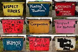
Today, a federally recognized tribe is in the community: the Village of Anaktuvuk Pass (a.k.a. Naqsragmiut Tribal Council). The community population is 82.36% Alaska Natives or part Native. Anaktuvuk Pass is a Nunamiut Eskimo community dependent upon subsistence activities. Sale, importation and possession of alcohol are banned in the village.[18]
As of 2020, an estimated 53.8% of residents speak a language other than English, most likely Iñupiaq, while 46.3% of adults only speak English.[7]
As of the census[7] of 2020, there were 425 people, 79 households, and 67 families living in the city. The population density was 81.3 inhabitants per square mile (31.4/km2). There were 79 housing units at an average density of 15.1 sq mi (39 km2). The racial makeup of the city was 16.7% White, 0.8% Black or African American, 82.36% Native American, and 0.92% from two or more races. Hispanic or Latino of any race were 0.71% of the population.
There were 79 households, of which 54.4% had children under the age of 18 living with them, 21.5% were married couples living together, 27.8% had a female householder with no husband present, and 15.1% were non-families. 28.6% of all households were made up of individuals, and 3.6% had someone living alone who was 65 or older. The average household size was 3.51 and the average family size was 3.69.
In the city, the population was spread out, with 43.3% under 18, 26.3% from 20 to 34, 20% from 34 to 64, and 6.5% who were 65 or older. The median age was 23. For every 100 females, there were 143 males. For every 100 females over 18, there were 161.7 males.
The median income for a household in the city was $83,250, and the median income for a family was $76,250. White individuals had a median income of $99,860 while $23,831 for Alaska Natives (2023 inflation-adjusted dollars). About 16.5% of households were below the poverty line.
Facilities, utilities, schools, health care and museum
The North Slope Borough provides all utilities to Anaktuvuk Pass. Two central wells and a treated watering point at Nunamiut School serve the town for water. Most households have water delivered by truck to holding tanks. A few residents haul their own water. Almost 80% of homes have running water in the kitchen. In 1996, a $17 million project to provide piped water and sewer and household plumbing began construction, which will provide flush toilets and showers for all residences. A new landfill is also near completion. Electricity is provided by North Slope Borough.
There is one school in the community, the Nunamiut School, attended by 110 students as of August 10, 2017.
The only local health clinic is the Anaktuvuk Pass Health Clinic, a primary health care facility. Anaktuvuk Pass is classified as an isolated village, found in EMS Region 6A in the North Slope Region. Emergency services have access to the town by air. Emergency service is provided by volunteers and health aides; there are no doctors on site. Auxiliary health care is provided by Anaktuvuk Pass Volunteer Fire Department.
The Nunamiut's culture and history is described and preserved through photographs and artifacts at the Simon Paneak Memorial Museum in Anaktuvuk Pass.[19] The curator of the Museum is Charles Hugo, a direct descendant of Inualuuraq Hugo, who took part in the 1949 Long Walk.
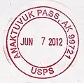
Anaktuvuk Pass post office was established in May 1951.[20] The first postmaster was Homer Mekiana.[21] It is considered the most isolated post office in the United States.[22]
Economy and transportation
Economic and employment opportunities are limited in Anaktuvuk Pass, due to its isolation. Hunting and trapping for sale of skins, guiding hunters, or making traditional caribou skin masks or clothing provides income, though some residents have sought seasonal employment outside the town.
Caribou is the primary source of meat, with other subsistence foods including trout, grayling, moose, sheep, brown bear, ptarmigan and water fowl.
Anaktuvuk Pass Airport, a 4,800 feet (1,463 m) gravel airstrip, is owned and operated by the North Slope Borough, and provides Anaktuvuk Pass with year-round access. A $3.4 million airport improvement project was completed by fall 1999, allowing many air companies to provide passenger flight service to Anaktuvuk Pass. There is no road to Anaktuvuk Pass, but Cat trains transport cargo from the Dalton Highway (which serves as the Trans-Alaska pipeline haul road) during the winter. Snowmobiles and all-terrain vehicles are used for local transportation, though some standard vehicles are used.
Media
Anaktuvuk Pass is home to two low-power FM translators. K268AB (FM 101.5) is a rebroadcaster of KBRW-FM, a public radio station in Utqiaġvik and K232DU, a rebroadcast of KYKD, a religious station from Bethel. Anaktuvuk Pass also has two low-power translators of the statewide Alaska Rural Communications Service on K04IX[23] and K09RS.[24]
Notable people
- Dennis Schmitt, veteran explorer, adventurer
See also
References
- ^ "Directory of Borough and City Officials 1974". Alaska Local Government. XIII (2). Juneau: Alaska Department of Community and Regional Affairs: 16. January 1974.
- ^ 2023 Alaska Municipal Officials Directory (PDF). Juneau: Alaska Municipal League. January 2023. p. 42. Retrieved November 12, 2023.
- ^ "2020 U.S. Gazetteer Files". United States Census Bureau. Retrieved October 29, 2021.
- ^ a b "Anaktuvuk Pass". Division of Community and Regional Affairs, Alaska Department of Commerce, Community and Economic Development. Retrieved January 24, 2013.
- ^ a b "Anaktuvuk Pass city, Alaska". Profile of General Population and Housing Characteristics: 2010 Demographic Profile Data. United States Census Bureau. Archived from the original on February 12, 2020. Retrieved January 23, 2013.
- ^ a b "Alaska Taxable 2011: Municipal Taxation – Rates and Policies" (PDF). Division of Community and Regional Affairs, Alaska Department of Commerce, Community and Economic Development. January 2012. Archived from the original (PDF) on April 25, 2013.
- ^ a b c "U.S. Census website". United States Census Bureau. Retrieved August 14, 2025.
- ^ Bright, William (2004). Native American Place Names of the United States. University of Oklahoma Press. p. 38. ISBN 9780806135984.
- ^ Stephen Adolphe Wurm, Peter Mühlhäusler, and Darrell T. Tyron (1996), Atlas of Languages of Intercultural Communication in the Pacific, Asia, and the Americas
- ^ "The Long Walk: The Origins of Anaktuvuk Pass". National Park Service. Retrieved August 14, 2025.
- ^ "The Long Walk: The Origins of Anaktuvuk Pass". National Park Service. Retrieved August 14, 2025.
- ^ Kauffmann, John M. (November 30, 1992). "People of the Weather". Alaska's Brooks Range: The Ultimate Mountains. Seattle, WA: Mountaineers Books. ISBN 978-0-89886-347-5.
- ^ "ANAKTUVUK AUTO, ALASKA Period of Record General Climate Summary - Temperature".
- ^ "POR - Station Metadata #2, ANAKTUVUK AUTO, ALASKA".
- ^ "ANAKTUVUK AUTO, ALASKA (500270)". DRI. Archived from the original on May 17, 2023.
- ^ "Census of Population and Housing". Census.gov. Retrieved June 4, 2015.
- ^ "1950 Census - Number of Inhabitants - Alaska" (PDF). U.S. Census Bureau.
- ^ "Anaktuvuk Pass". National Park Service. Retrieved February 20, 2019.
- ^ Many Authors. "Environmentalists Lend Their Support". North Slope Borough. Retrieved September 23, 2007.
- ^ http://webpmt.usps.gov/pmt011.cfm
- ^ Dickerson, Ora B. (1989) 120 Years of Alaska Postmasters, 1867–1987, p. 18. Scotts, Michigan: Carl J. Cammarata
- ^ "Postal Facts 2009" (PDF). United States Postal Service.
- ^ K04IX Anaktuvuk Pass AK US
- ^ K09RS Anaktuvuk Pass AK US
Further reading
- Cline, Michael S. Tannik School: The Impact of Education on the Eskimos of Anaktuvuk Pass. Anchorage: Alaska Methodist University Press, 1975.
- Gubser, Nicholas J. The Nunamiut Eskimos, Hunters of Caribou. New Haven: Yale University Press, 1965.
- Ingstad, Helge Nunamiut – Among Alaska's Inland Eskimos. New York City: W. W. Norton, 1954
External links
- Anaktuvuk Pass at the Community Database Online from the Alaska Division of Community and Regional Affairs
- Maps from the Alaska Department of Labor and Workforce Development: 2000, 2010
- Weather Cam from the Alaska FAA website
- Photo of the Anaktuvuk Pass airport and the town of Anaktuvuk Pass from the air
- Video Documentary- 50 Years of Northern Light, a look at Anaktuvuk Pass as reflected by the village church building. Directed by Caven Keith, 2011
Municipalities and communities of North Slope Borough, Alaska, United States | ||
|---|---|---|
| Cities |  | |
| CDPs | ||
| Unincorporated communities | ||
| Ghost towns | ||
