Al Jumail
Al Jumail
اَلْجُمَيْل | |
|---|---|
Abandoned town | |
 Aerial view of Al Jumail | |
 Al Jumail Location in Qatar | |
| Coordinates: 26°05′59″N 51°09′40″E / 26.09972°N 51.16111°E[1] | |
| Country | |
| Municipality | Al Shamal |
| Zone | Zone 78 |
| District no. | 395 |
| Area | |
• Total | 2.3 sq mi (6.0 km2) |
Al Jumail (Arabic: اَلْجُمَيْل) is an abandoned village in north-east Qatar located in the municipality of Al Shamal.[3][4] It was an important town in the northern peninsula prior to the 21st century.
Nearby settlements include Ruwayda to the south-west and Yusufiyah and Abu Dhalouf to the north.
Etymology
Two main explanations exist for the town's name. The first states that the name name comes from the Arabic word jameel, which means "beautiful"; a reference to the trees that grow in the area year-round.[4] The other theory states that the name is diminutive of the Arabic word for "camel".[5]
Various alternative transliterations of the name are used, such as Al Jemail, Al Jamil,[1] Lumail,[6] and Yamail.[7]
History
According to tradition, members of the Al Hassan branch of the Al Muhannadi tribal confederation settled in Al Jumail in the mid 18th century. Before settling in Al Jumail, the Al Hassan clan and other branches of the Al Muhannadi confederation had initially established themselves in Al Khor. Over time, the group relocated north to Al Jumail, where they built homes and a defensive wall around the village. Several other families accompanied them, including Musnad bin Saad, ancestor of the Al Musnad family, as well as Mohammed bin Amir Al Humaidi and Salih bin Amir. These families established stone fish traps (locally known as masakir) along the Al Jumail coast.[8]
The foundations of the wall built by Isa bin Salman Al Hassan Al Muhannadi remain standing to this day. He is also credited with constructing a large masakir in Al Jumail as an act of religious charity. After an unspecified period, the Al Hassan family returned to Al Khor.[8]
In the 1820s, George Barnes Brucks was tasked with preparing the first British survey of the Persian Gulf.[9] He documented Al Jumail in this survey, referring to it as "Yamale" and concisely stating that "Yamale, in lat. 26° 5' 40" N., long. 51° 14' E., is a small village."[10]
In J.G. Lorimer's Gazetteer of the Persian Gulf written in 1908, he makes mention of Jumail, noting its location as "midway between Abu Dhalouf and Khor Hassan", and states that it is also called Yamail or Lumail. He goes on to state that there are remains of houses and a fort.[11]
Geography
Al Jumail is situated along Qatar's northern region. The coastline near Al Jumail includes various water inlets, both circular and elongated in shape. The area between Al Jumail and Ar Ru'ays is characterized by a narrowing of the coastal strip. This contrasts with the wider coastal areas found to the east. As part of the northern coastal plain region of Qatar, the surrounding area is notable for its flat terrain and lacks complex topographical features.[12]
Gallery
-
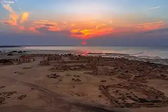 Aerial view of the village, looking west
 -
 Al Hussein Mosque in Al Jumail overlooked by dark clouds.
 -
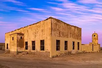 The area around Al Hussein Mosque.
References
- ^ a b "Al-Jamil: Qatar". geographic.org. Retrieved 19 January 2019.
- ^ "District Area Map". Ministry of Development Planning and Statistics. Retrieved 20 May 2019.
- ^ "Qatar Development Atlas - Part 1" (PDF). Ministry of Development Planning and Statistics. 2010. p. 10. Archived from the original (PDF) on 18 July 2020. Retrieved 19 January 2019.
- ^ a b "Geoportal". The Centre for Geographic Information Systems of Qatar. Archived from the original on 24 November 2020. Retrieved 18 January 2019.
- ^ Amer, Ismail; Al-'Arifi, Saleh; Babiker, Ahmad Abdullah; Al-Nasr, Bassam; Abdul Karim, Nidham; Al-Kuwari, Fatima; Al-Shayb, Ali Ibrahim; Aziz, Mohammed Al-Khuzami; Fakhro, Nasser Abdulrahman; Al-Kuwari, Mohammed Khalifa (1998). Al-Khayyat, Hassan; Al-Emadi, Hassan Darwish (eds.). موسوعة المعلومات القطرية - المجلد الجغرافي [Encyclopedia of Qatari Information - The Geographical Volume] (in Arabic). Doha: College of Humanities and Social Sciences, University of Qatar. p. 28.
- ^ "Lumail: Qatar". geographic.org. Retrieved 28 February 2019.
- ^ "Yamail: Qatar". geographic.org. Retrieved 28 February 2019.
- ^ a b Al Hassan Al Muhannadi, Ali bin Khamees (2005). Al Fayyadh, Ali Abdullah; Funais Al Manaei, Ali (eds.). ذاكرة الذخيرة (Memories of Al Thakhira) (in Arabic). Doha: National Council for Culture, Arts and Heritage. pp. 53–55.
- ^ Mark Hobbs. "George Barnes Brucks and the First English Survey of the Gulf". Qatar Digital Library. Retrieved 19 January 2019.
- ^ G.B. Brucks; Robert Hughes Thomas (1856). "Historical and other information connected with place in the Persian Gulf". Bombay Education Society's Press. p. 562. This article incorporates text from this source, which is in the public domain.
- ^ "'Gazetteer of Arabia Vol. II' [1497] (570/688)". Qatar Digital Library. Retrieved 2 June 2024.
- ^ "طبوغرافية شبه جزيرة قطر" (in Arabic). Qatar Historical Encyclopedia. 28 April 2024. Retrieved 20 July 2024.
Capital: Madinat ash Shamal | |||||
| Zone 77 |
| ||||
| Zone 78 |
| ||||
| Zone 79 |
| ||||