Adaville, Iowa
Adaville, Iowa | |
|---|---|
 Adaville, Iowa | |
| Coordinates: 42°45′03″N 96°24′16″W / 42.7508257°N 96.4044726°W | |
| Country | United States |
| State | Iowa |
| Elevation | 1,309 ft (399 m) |
| Time zone | UTC-6 (Central (CST)) |
| • Summer (DST) | UTC-5 (CDT) |
| GNIS feature ID | 464438[1] |
Adaville is an unincorporated community in Plymouth County, in the U.S. state of Iowa.
Geography
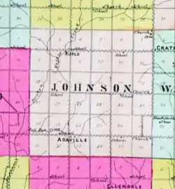
Adaville lies near the junction of County Road C38 and Fir Avenue (an unpaved gravel road), in sections 28 and 33 of Johnson Township.[2] It lies 14 miles (23 km) from LeMars the county seat.[3] Adaville lies in the southern part of the township, with nearby Ruble, Iowa, in the northern part of the township.[4]
History
The first post office in Adaville opened sometime prior to 1857, and was discontinued in May 1857.[5] The Adaville United Methodist Church was founded in 1871.[6]
The Adaville store opened on May 1, 1892, with the O.R. Gaston family the original owners. The store sold general merchandise, including farm equipment. Adaville also had a school during this period, and O.R. Gaston taught the school while Ella Morehead Gaston ran the store.[7]
Adaville's second post office opened in 1889.[8]
The community's population was 6 in 1900.[9] The Adaville post office closed for the second time in 1904.[8] The Adaville High School operated during this period.[10]
Adaville's population was 18 in 1920.[11]
The Adaville store remained open, under various owners, until closing during the Great Depression.[7] By the 1930s, Adaville was listed in The Annals of Iowa, an influential history periodical, as an abandoned town.[12]
By 1940, Adaville's population was 10.[3] The Adaville store reopened in 1946, and closed again in 1956. The property was sold in 1958, and the building was razed in the early 1960s.[7]
The community still appears on county highway maps,[2] with the Adaville Church being the most visible building. The church celebrated its centenary in 1971.[6]
See also
References
- ^ U.S. Geological Survey Geographic Names Information System: Adaville, Iowa
- ^ a b "Highway and Transportation Map - Plymouth County, Iowa" (PDF). IowaDOT.gov. 2024. Archived from the original on December 8, 2024. Retrieved August 7, 2025.
{{cite web}}: CS1 maint: bot: original URL status unknown (link) - ^ a b The Attorneys List. United States Fidelity and Guaranty Company, Attorney List Department. 1940. p. 292.
- ^ "Standard Historical Atlas of Plymouth County, Iowa". Anderson and Goodwin Company. 1907. Retrieved August 7, 2025.
- ^ "Iowa at Washington". Marshalltown Evening Times Republican. May 8, 1857. p. 5.
- ^ a b Bryant, Eldon J. (1971). Adaville United Methodist Church History.
- ^ a b c Ziemann, Linda Ewin (2009). Plymouth County. Charleston, SC. p. 64. ISBN 978-0-7385-6083-0.
{{cite book}}: CS1 maint: location missing publisher (link) - ^ a b "Post Offices". www.postalhistory.com. Retrieved November 8, 2022.
- ^ Cram's Modern Atlas: The New Unrivaled New Census Edition. J. R. Gray & Company. 1902. pp. 203–207.
- ^ "Adaville". LeMars Sentinel. Le Mars, IA. September 10, 1909.
- ^ Premier Atlas of the World: Containing Maps of All Countries of the World, with the Most Recent Boundary Decisions, and Maps of All the States, Territories, and Possessions of the United States with Population Figures from the Latest Official Census Reports, Also Data of Interest Concerning International and Domestic Political Questions. Rand McNally & Company. 1925. p. 190.
- ^ Mott, D.C. (1931). "The Annals of Iowa". Archived from the original on July 23, 2024. Retrieved August 7, 2025.
Municipalities and communities of Plymouth County, Iowa, United States | ||
|---|---|---|
| Cities |  | |
| Unincorporated communities | ||
| Footnotes | ‡This populated place also has portions in an adjacent county or counties | |