A67 road
 | ||||
|---|---|---|---|---|
 Click map to enlarge | ||||
| Route information | ||||
| Length | 33.1 mi[1] (53.3 km) | |||
| Major junctions | ||||
| West end | ||||
| East end | ||||
| Location | ||||
| Country | United Kingdom | |||
| Counties | County Durham North Yorkshire | |||
| Primary destinations | Barnard Castle Darlington | |||
| Road network | ||||
| ||||
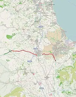
The A67 is a road in England that links Bowes in County Durham with Crathorne in North Yorkshire. The road from Middlesbrough to Darlington was previously the A66 road, the road also starts and ends on the A66.
Route
The section from the A66 to Barnard Castle is primary status;[2] from that point it turns right and it loses its primary status to the A688 road.[3] It then travels east through Gainford and crosses the A1(M) but does not have a junction with it.[4] The road regains primary status as it goes concurrent with the A66 road from the Blackwell roundabout and heads along the southern edge of Darlington.[5]
As the A66 heads north, the A67 leaves at Morton Park to head east past Dinsdale and Durham Tees Valley Airport before joining with the A135 in Eaglescliffe. From there it heads south through Yarm—crossing the Tees via Yarm Bridge[6] —and Kirklevington before joining the A19 road at Crathorne.[7]
The road has been described by a UK Government transport minister as an important commuter route and as being the gateway to Teesdale from Darlington.[8] Despite its status as an important route, it is not maintained by National Highways but by the local authority.[9] The section around Darlington and also onwards towards Middlesbrough was originally the A66.[10]
Safety
The 10-mile (16 km) stretch of road between the A66 at Morton Park and the A19 was named the third most improved road in 2013. Work on this section included vehicle activated signage, draining and resurfacing.[11]
Settlements

- Bowes (junction with A66 road)
- Barnard Castle
- Gainford
- Piercebridge
- Darlington
- Teesside International Airport
- Eaglescliffe
- Yarm
- Crathorne (junction with A19 road)
Junction list
| County | Location | mi[1] | km | Destinations | Notes |
|---|---|---|---|---|---|
| County Durham | Bowes | 0.0 | 0.0 | Western terminus | |
| Barnard Castle | 4.9 | 7.9 | Southwestern terminus of A688 | ||
| Darlington | 19.9 | 32.0 | Western terminus of A66 concurrency | ||
| Morton Palms | 23.3 | 37.5 | Stockton and M'brough signed eastbound only, To A1150, Teesside and Durham westbound only; eastern terminus of A66 concurrency | ||
| Egglescliffe | 29.7 | 47.8 | Southern terminus of A135 | ||
| County Durham– North Yorkshire boundary | Egglescliffe– Yarm boundary | 29.8 | 48.0 | Yarm Bridge over River Tees | |
| North Yorkshire | Yarm– Kirklevington boundary | 31.1 | 50.1 | Southwestern terminus of A1044 | |
| Kirklevington– Crathorne boundary | 32.9– 33.1 | 52.9– 53.3 | Eastern terminus | ||
1.000 mi = 1.609 km; 1.000 km = 0.621 mi
| |||||
References
- ^ a b "54.5190999, -2.0090285 to 74 Merrybent, Darlington DL2 2LE, UK to Urlay Nook Rd, Stockton-on-Tees TS16 0LH, UK to 12 A67, Stockton-on-Tees, Yarm TS15 0AY, UK". Google Maps. Retrieved 30 July 2025.
- ^ Wafer, dave. "Funding for Local Transport Safer Roads Fund" (PDF). durham.gov.uk. p. 2. Retrieved 8 November 2017.
- ^ "92" (Map). Barnard Castle & Richmond. 1;50,000. Landranger. Ordnance Survey. 2016. ISBN 9780319261903.
- ^ "304" (Map). Darlington & Richmond. 1;25,000. Explorer. Ordnance Survey. 2015. ISBN 9780319245569.
- ^ "A67 - Roader's Digest: The SABRE Wiki". www.sabre-roads.org.uk. Retrieved 8 November 2017.
- ^ Betteney, Alan (2019). "Crossing the Tees: Fords, Ferries and Bridges" (PDF). River Tees Rediscovered. Tees Archaeology: 23–26. Archived from the original (PDF) on 13 March 2023. Retrieved 11 July 2024.
- ^ "The A19 Trunk Road (Crathorne Interchange to Parkway Interchange)" (PDF). legislation.gov.uk. 2014. p. 1. Retrieved 8 November 2017.
- ^ "Landslip road needs £4m funding". BBC News. 9 November 2013. Retrieved 7 November 2017.
- ^ Seddon, Sean (21 September 2017). "Why the A19 is missing out on funding to save lives on the road". nechronicle. Retrieved 7 November 2017.
- ^ Bax, A.; Fairfield, S. (1978). The Macmillan guide to the United Kingdom 1978-79 (2 ed.). London: Macmillan. p. 217. ISBN 978-0-333-19908-4.
- ^ "Teesside's A67 route hailed in road safety report". Gazette Live. 4 July 2010. Retrieved 7 November 2017.
External links
 Media related to A67 road (England) at Wikimedia Commons
A roads in Zone 6 of the Great Britain road numbering scheme | ||
|---|---|---|
54°31′47″N 1°38′24″W / 54.52982°N 1.64006°W