Ōhiwa
Ōhiwa | |
|---|---|
Rural settlement | |
 Ōhiwa Beach Road | |
| Coordinates: 37°59′24″S 177°09′40″E / 37.990°S 177.161°E | |
| Country | New Zealand |
| Region | Bay of Plenty |
| Territorial authority | Ōpōtiki District |
| Ward | Waioeka-Waiōtahe-Otara Ward |
| Electorates | |
| Government | |
| • Territorial authority | Ōpōtiki District Council |
| • Regional council | Bay of Plenty Regional Council |
| • Mayor of Ōpōtiki | David Moore[1] |
| • East Coast MP | Dana Kirkpatrick[2] |
| • Waiariki MP | Rawiri Waititi[3] |
| Area | |
• Total | 3.96 km2 (1.53 sq mi) |
| Population (June 2024)[5] | |
• Total | 180 |
| • Density | 45/km2 (120/sq mi) |
| Postcode(s) | 3174 |
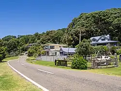
Ōhiwa is a rural settlement in the Ōpōtiki District and Bay of Plenty Region of New Zealand's North Island. It is on a headland on the eastern side of Ōhiwa Harbour, and on the western side of the Waiotahe River mouth.[6]
The New Zealand Geographic Board officially included the macron in the name from 16 July 2020.[7]
The Ferry Hotel was opened at Ōhiwa in 1873, together with a ferry service to Ōhope. A post office opened in the growing town in 1877. Unstable sand and erosion from 1915 destroyed the town. A second attempt to create sections for baches in the 1960s was also lost to erosion in 1978.[8]
Onekawa Te Mawhai Regional Park was created on the headland in 2010. It incorporates areas of archaeological importance from long Māori use of the area, including Onekawa pā.[9]
A local campground provides accommodation.[10]
Demographics
Ōhiwa is described by Statistics New Zealand as a rural settlement, which covers 3.96 km2 (1.53 sq mi).[4] It had an estimated population of 180 as of June 2024,[5] with a population density of 45 people per km2. It is part of the larger Waiotahi statistical area.[11]
| Year | Pop. | ±% p.a. |
|---|---|---|
| 2006 | 177 | — |
| 2013 | 156 | −1.79% |
| 2018 | 171 | +1.85% |
| 2023 | 177 | +0.69% |
| Source: [12][13] | ||
Ōhiwa had a population of 177 in the 2023 New Zealand census, an increase of 6 people (3.5%) since the 2018 census, and an increase of 21 people (13.5%) since the 2013 census. There were 90 males, 84 females, and 3 people of other genders in 84 dwellings.[14] 1.7% of people identified as LGBTIQ+. The median age was 61.7 years (compared with 38.1 years nationally). There were 12 people (6.8%) aged under 15 years, 12 (6.8%) aged 15 to 29, 81 (45.8%) aged 30 to 64, and 69 (39.0%) aged 65 or older.[12]
People could identify as more than one ethnicity. The results were 93.2% European (Pākehā), 18.6% Māori, 3.4% Asian, and 3.4% other, which includes people giving their ethnicity as "New Zealander". English was spoken by 98.3%, Māori by 3.4%, and other languages by 5.1%. The percentage of people born overseas was 16.9, compared with 28.8% nationally.[12]
Religious affiliations were 23.7% Christian, 1.7% Hindu, 1.7% Māori religious beliefs, and 3.4% other religions. People who answered that they had no religion were 67.8%, and 3.4% of people did not answer the census question.[12]
Of those at least 15 years old, 45 (27.3%) people had a bachelor's or higher degree, 96 (58.2%) had a post-high school certificate or diploma, and 24 (14.5%) people exclusively held high school qualifications. The median income was $30,300, compared with $41,500 nationally. 15 people (9.1%) earned over $100,000 compared to 12.1% nationally. The employment status of those at least 15 was 60 (36.4%) full-time, 24 (14.5%) part-time, and 6 (3.6%) unemployed.[12]
References
- ^ "Mayor and Councillors". Ōpōtiki District Council. Retrieved 18 July 2025.
- ^ "East Coast - Official Result". Electoral Commission. Retrieved 1 June 2025.
- ^ "Waiariki – Official Result". Electoral Commission. Retrieved 12 May 2025.
- ^ a b "Stats NZ Geographic Data Service". Urban Rural 2023 (generalised). Retrieved 18 July 2025.
- ^ a b "Aotearoa Data Explorer". Statistics New Zealand. Retrieved 26 October 2024.
- ^ Harriss, Gavin (August 2022). Ohiwa, Bay of Plenty (Map). NZ Topo Map.
- ^ "Notice of Approved Official Geographic Names". New Zealand Gazette. 16 July 2020.
- ^ Quinn, Peter James (May 2002). "Ohiwa – The food basket of many hands". New Zealand Geographic Magazine.
- ^ "Onekawa Te Mawhai Regional Park". Bay of Plenty Region. Retrieved 12 January 2023.
- ^ "Ohiwa Beach". Tasman Holiday Parks. Retrieved 12 January 2023.
- ^ "Geographic Boundary Viewer". Stats NZ. Urban Rural – 2023 and Statistical Area 2 – 2023.
- ^ a b c d e "Totals by topic for individuals, (RC, TALB, UR, SA3, SA2, Ward, Health), 2013, 2018, and 2023 Censuses". Stats NZ – Tatauranga Aotearoa – Aotearoa Data Explorer. Ōhiwa (1265). Retrieved 3 October 2024.
- ^ "Statistical area 1 dataset for 2018 Census". Statistics New Zealand. March 2020. 7015415.
- ^ "Totals by topic for dwellings, (RC, TALB, UR, SA3, SA2, Ward, Health), 2013, 2018, and 2023 Censuses". Stats NZ – Tatauranga Aotearoa – Aotearoa Data Explorer. Retrieved 3 October 2024.